
A river can saw a gash 1,800 meters deep, but the river is not the thing that moved.
Image: Google Doodle, Celebrating National Parks Week: Grand Canyon · No guest artist is credited on the official page · Official page (Doodle artwork © Google)
National Park Week begins today, Saturday, August 22, and runs through August 30. Google prepared more than one Doodle for the week. This one depicts the Grand Canyon.
The official description is plain: the Doodle opens National Park Week with Grand Canyon National Park, one of the country's most popular parks for first-time visitors, and presents the natural beauty of its iconic views. No guest artist is named, so there is no reason to guess. The official doodles.google page dates the Doodle to August 22, matching the date of this article.
The small picture is not the part worth lingering over. The object it shows is, because almost everyone misunderstands the Grand Canyon the first time.
A River Does Not Dig a Hole
We learn that the Colorado River carved the Grand Canyon. That is not wrong, but it suggests the wrong image: a river drilling underground like a bit, making a pit 1,800 meters deep.
That is not what happened. A river does not drill downward. It simply remains on the lowest available line.
The ground moved. In its geological-heritage description, the International Union of Geological Sciences uses the present tense: the canyon is being cut by the erosive power of the Colorado River and its tributaries into the rising Colorado Plateau. The US Geological Survey puts the causality more simply. Uplift gave the plateau enough elevation for water to flow downhill and cut into the rock as it went.
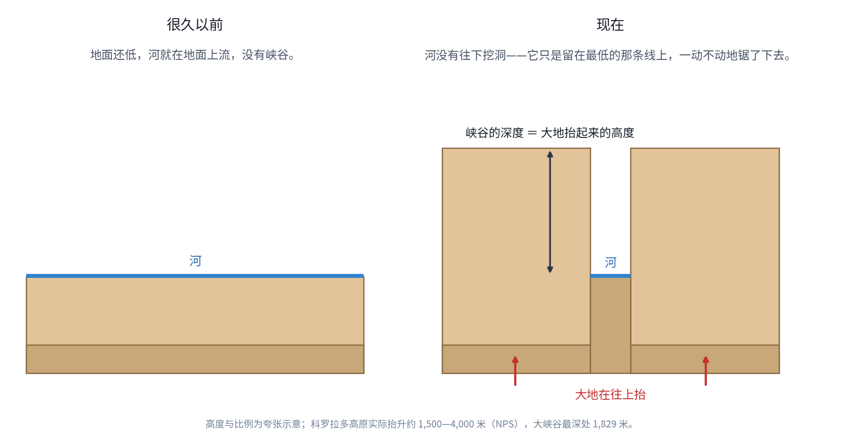
According to the National Park Service, the Colorado Plateau rose to elevations between 5,000 and 13,000 feet, or about 1,500 to 4,000 meters. As the plateau climbed, the river sawed into it, always along the lowest line.
The canyon's depth is therefore a record of how high the land rose. The void below the South Rim was not scooped out while everything else stayed still. The rest of the landscape grew upward.
Once this picture is in mind, the canyon changes. It is not a wound but a ruler, recording the rise of a continent.
Walking from Rim to River Means Walking Through Time
The Grand Canyon's other great power is that it turns time upright.
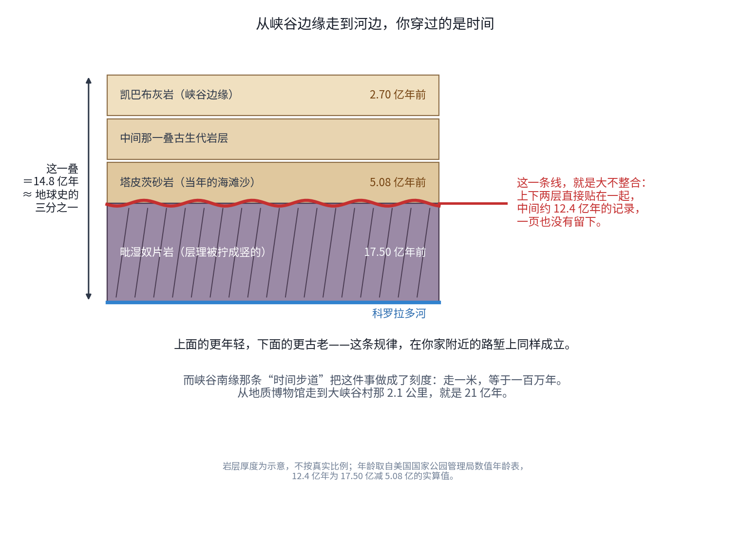
At the South Rim, the rock underfoot is the Kaibab Limestone, deposited 270 million years ago. At river level, the trail reaches Vishnu Schist, intensely metamorphosed 1.75 billion years ago.
The difference is 1.48 billion years. The NPS says the exposed rocks in the canyon walls record about one third of Earth's history. The arithmetic supports it: 1.48 billion divided by Earth's age of 4.56 billion years is 32.5 percent. If an older body of rock in the canyon is included, the IUGS gives an age of 1.84 billion years, or roughly 40 percent. Those figures describe different things and should not be conflated.
But the most astonishing feature is not the 1.48 billion years. It is the gap inside them.
An interface separates Tapeats Sandstone, beach sand laid down 508 million years ago, from 1.75-billion-year-old Vishnu Schist. The name given to it after John Wesley Powell's 1869 expedition is the Great Unconformity. The rocks above and below lie directly against one another. About 1.24 billion years of geological record are missing completely.
That number comes directly from subtraction: 1.750 billion minus 508 million equals 1.242 billion, consistent with the official description of "about 1.2 billion years." One further caveat is worth preserving. On the same NPS page, one passage calls the gap 30 percent of Earth history and another says 25 percent. Using its own age for Earth, 4.56 billion years, 1.2 billion works out to 26.3 percent. "About one quarter" is defensible; "about 30 percent" is not. Pointing out the mismatch is not pedantry. Every number, including an official one, can be followed to its origin.
The NPS description is visually precise. The erosional contact divides the vertically oriented fabric of the Vishnu Schist below from horizontal Paleozoic strata above.
One finger can cover the line. Above it is beach sand from 508 million years ago. Below it is metamorphic rock twisted upright 1.75 billion years ago. A finger's width crosses 1.2 billion years.
The book survives, but hundreds of pages have been torn from its middle, and the torn edge remains visible.
A trail on the South Rim turns this history into a scale. The Trail of Time follows one rule: every meter walked on its timeline represents one million years of Grand Canyon geology. Its full length is 4.56 kilometers. Multiply 4,560 meters by one million years per meter and the result is 4.56 billion years: the length of the trail is the age of Earth. The 2.1 kilometers from the geology museum to Grand Canyon Village represent 2.1 billion years.
A Few Numbers at Human Scale
These are official NPS figures. The Grand Canyon is 277 miles, or 446 kilometers, long, from Lees Ferry to the Grand Wash Cliffs. Near Grand Canyon Village it is 10 miles, or 16 kilometers, wide; elsewhere it reaches 18 miles, or 29 kilometers. Its maximum depth is 6,000 feet, or 1,829 meters. Elevation inside the park rises from 348 meters at the Colorado River to 2,798 meters on the North Rim.
At 300 kilometers per hour, a nonstop high-speed train would need 1 hour 29 minutes to cover 446 kilometers. A person walking four kilometers per hour for eight hours a day would need about 14 days.
A depth of 1,829 meters equals 2.89 Shanghai Towers, each 632 meters tall, stacked vertically. At three meters per residential floor, it is 610 stories.
The more useful mental scale is simpler: the void visible from the South Rim is large enough to hold an entire mountain.
It Is Not the World's Deepest
That distinction should be stated clearly, and it leads back to China.
The world's deepest canyon is the Yarlung Tsangpo Grand Canyon.
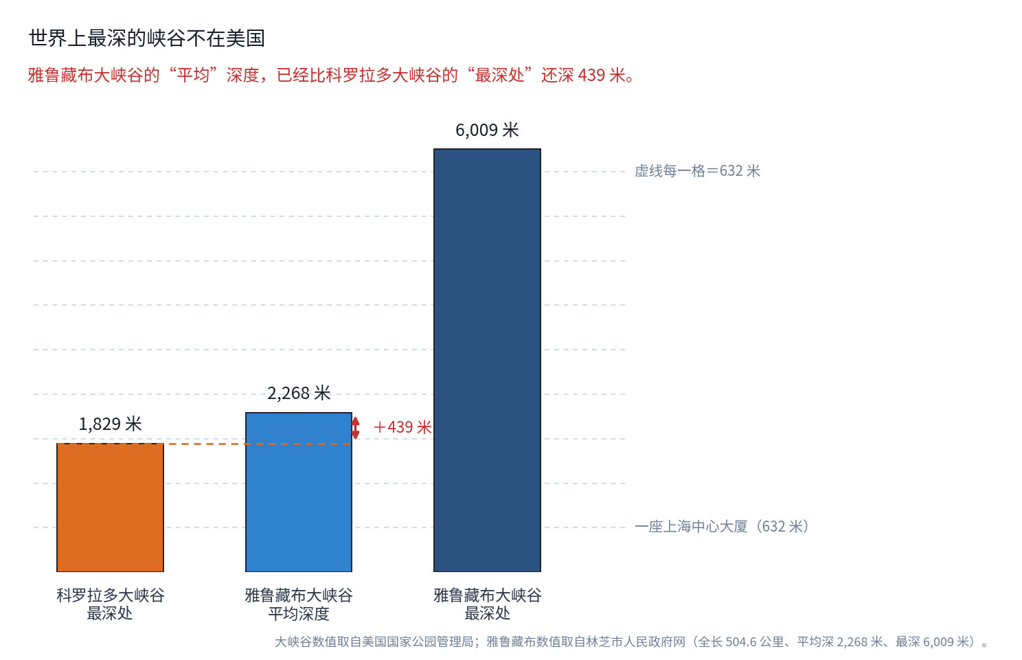
Official figures from the Nyingchi municipal government give it a length of 504.6 kilometers, an average depth of 2,268 meters, and a maximum depth of 6,009 meters. It begins at Daduka Village in Pai Town, Mainling County, at an elevation of 3,000 meters, passes the great bend of the Yarlung Tsangpo near Pailong Township, and ends at Baxika Village in Mêdog County, at 115 meters.
Put the two sets of figures side by side and the comparison is difficult to absorb.
The Yarlung Tsangpo's average depth of 2,268 meters already exceeds the Grand Canyon's maximum of 1,829 meters by 439 meters. Its greatest depth, 6,009 meters, is 3.29 times the Grand Canyon's maximum. At 504.6 kilometers against 446, it is also 13 percent longer.
Chinese scientists established the distinction through fieldwork. According to an account in the People's Daily, Yang Yichou became one of the first Chinese scientists to enter the Yarlung Tsangpo Grand Canyon in 1973. On April 17, 1994, Xinhua released an exclusive report announcing that Chinese scientists had demonstrated that it was the world's greatest canyon. The State Council approved the formal name Yarlung Tsangpo Grand Canyon in 1998, and surveying authorities released precise measurements in 1999.
Why can it grow so deep? Because uplift and incision are both operating near their limits.
The Yarlung Tsangpo makes a horseshoe bend beside Namcha Barwa. Research published in the Geological Society of America Bulletin concluded that rock uplift and erosion by river incision there have remained in a sustained balance for at least roughly the past million years. The mountain keeps rising and the river keeps sawing downward at a matching rate. Related research measured bedrock exhumation above 7 millimeters per year, with some exposed granite as young as one million years. The river descends roughly 2,000 meters through an irregular, approximately 100-kilometer gorge reach. Erosion in this region supplies fully 50 percent of the Yarlung Tsangpo's modern suspended sediment load, about 100 million metric tons per year. Researchers described it as one of the most geologically active regions on Earth.
A popular-science submission by Ma Jiayi on a Chinese Academy of Sciences platform offers a memorable detail. Between Pai and Mêdog, the river drops more than 2,000 meters over 300 kilometers, but there is no single enormous waterfall. Instead, thousands of miniature falls form a continuous riverbed, turning what might resemble one long slide toward the Indian Ocean into a staircase with ten thousand steps. That configuration dissipates the water's energy and reduces the rate of downcutting. This is a popular-science submission, not a peer-reviewed paper, so the image is offered with that qualification.
Two canyons, two modes of construction: one formed as a plateau rose slowly and a river patiently cut for five or six million years; the other as a mountain grew rapidly and a river raced to cut downward with it. Both answer the same question: how did time sculpt this land?
Life in the Canyon
The Grand Canyon is also a continent turned upright.
An often-quoted NPS account of C. Hart Merriam's survey more than a century ago says that over only 50 miles, or 80 kilometers, from rim to river, crossing 10,000 feet, or 3,048 meters, the change in life was equivalent to traveling 1,750 miles, or 2,816 kilometers, from Canada to Mexico. That is the agency's wording. The conversion gives about 25 degrees of latitude, more than the actual latitudinal difference between the Canadian and Mexican borders of the United States, so the statement is quoted rather than silently rewritten.
The park consequently contains five life zones, from desert scrub at the river to mixed conifer forest on the North Rim, with 1,750 vascular plant species, several hundred bird species, and nearly 100 mammal species.
Two animals deserve special attention.
One is the California condor. In 1982, only 22 remained in the world, at the edge of extinction. Captive breeding began in 1983. On December 12, 1996, the first group was released at Vermilion Cliffs National Monument, just north of the Grand Canyon. By the end of 2025, the US Fish and Wildlife Service counted 607 condors in total, 392 in the wild, including 98 in Arizona and Utah.
The total is 27.6 times the 22 birds alive in 1982. The 98 in Arizona and Utah make up 25 percent of all wild condors: one in every four California condors flying free is in the Grand Canyon region. This December 12 will mark 30 years since the first release.
The NPS condor page still says the global population exceeds 300 and that more than 70 live in Arizona and Utah. That page is out of date. The figures here come from the Fish and Wildlife Service's 2025 annual population report. The discrepancy itself records the success of those 30 years.
The other is the Grand Canyon rattlesnake. Six rattlesnake species occur in the park. The Grand Canyon rattlesnake, Crotalus oreganus abyssus, is found nowhere else in the world. It is often described as pink, supposedly as camouflage against canyon rock, but no primary source for why it is pink was found. The verifiable statement is narrower: this subspecies occurs only here.
People
The canyon is not empty country. The NPS says 11 Tribes have historic connections to the lands and resources now found within Grand Canyon National Park. The Havasupai still live inside the canyon.
What does that mean in practical terms? The US Postal Service supplies one answer. Mail reaches Supai Village at the bottom of the canyon by mule train. Five days a week, a train of 10 to 22 mules descends a nine-mile trail. Each mule carries no more than 200 pounds, with equal weight on both sides for balance, while a wrangler follows on horseback. USPS calls it "the most unusual mode of delivery used by the Postal Service." It does not call it the only one, so neither will we.
The timing is revealing: three hours down and five hours back up. The ascent takes 1.67 times as long.
Congress established Grand Canyon National Park by legislation signed by President Woodrow Wilson on Wednesday, February 26, 1919. It is now 107 years old; this year's anniversary passed on February 26. UNESCO inscribed it as World Heritage Site 75 in 1979. UNESCO's introduction calls the canyon, carved by the Colorado River and nearly 1,500 meters deep, the world's most spectacular gorge. For depth, this article uses the park's figure of 1,829 meters; 1,500 meters is the wording of the 1979 inscription summary.
Coda
Tomorrow the small Doodle will disappear from Google's homepage. The canyon it depicts will continue to deepen: the plateau is still rising and the river is still cutting.
Its untidy contacts and stacked layers preserve both what happened and what is missing. The visible break between them is the same process that made the Grand Canyon.
Sources: official doodles.google page; National Park Service pages on Grand Canyon frequently asked questions, geologic structures, numerical ages, the Great Unconformity and Paleozoic strata, Trail of Time, ecology and inventory monitoring, reptiles, California condors, associated Tribes, administrative history, North Rim status (updated August 15, 2026), North Rim reopening, fees, shuttle buses, Bright Angel Trail, day hiking, dark-sky certification, virtual tours, and webcams; US Geological Survey Grand Canyon geology page; US Fish and Wildlife Service, 2025 California Condor Population Status report; International Union of Geological Sciences geological-heritage entry for the Grand Canyon; UNESCO World Heritage Site 75 and Enshi Grand Canyon-Tenglongdong UNESCO Global Geopark; US Postal Service Postal Facts page on mule-train delivery; Library of Congress, "Today in History - February 26"; Nyingchi municipal government pages on the Yarlung Tsangpo Grand Canyon and its 5A tourism designation; People's Daily, "How the Yarlung Tsangpo Grand Canyon Was Discovered"; Finnegan et al. (2008), GSA Bulletin; Zeitler et al. (2007), HKT workshop abstract; and a popular-science submission to the Chinese Academy of Sciences platform Science Wisdom Sparks. Anniversary counts, age differences, depth ratios, and unit conversions were independently recalculated.