
Why does a mountain road need so many bends? The answer is not in the scenery but in the gradient.
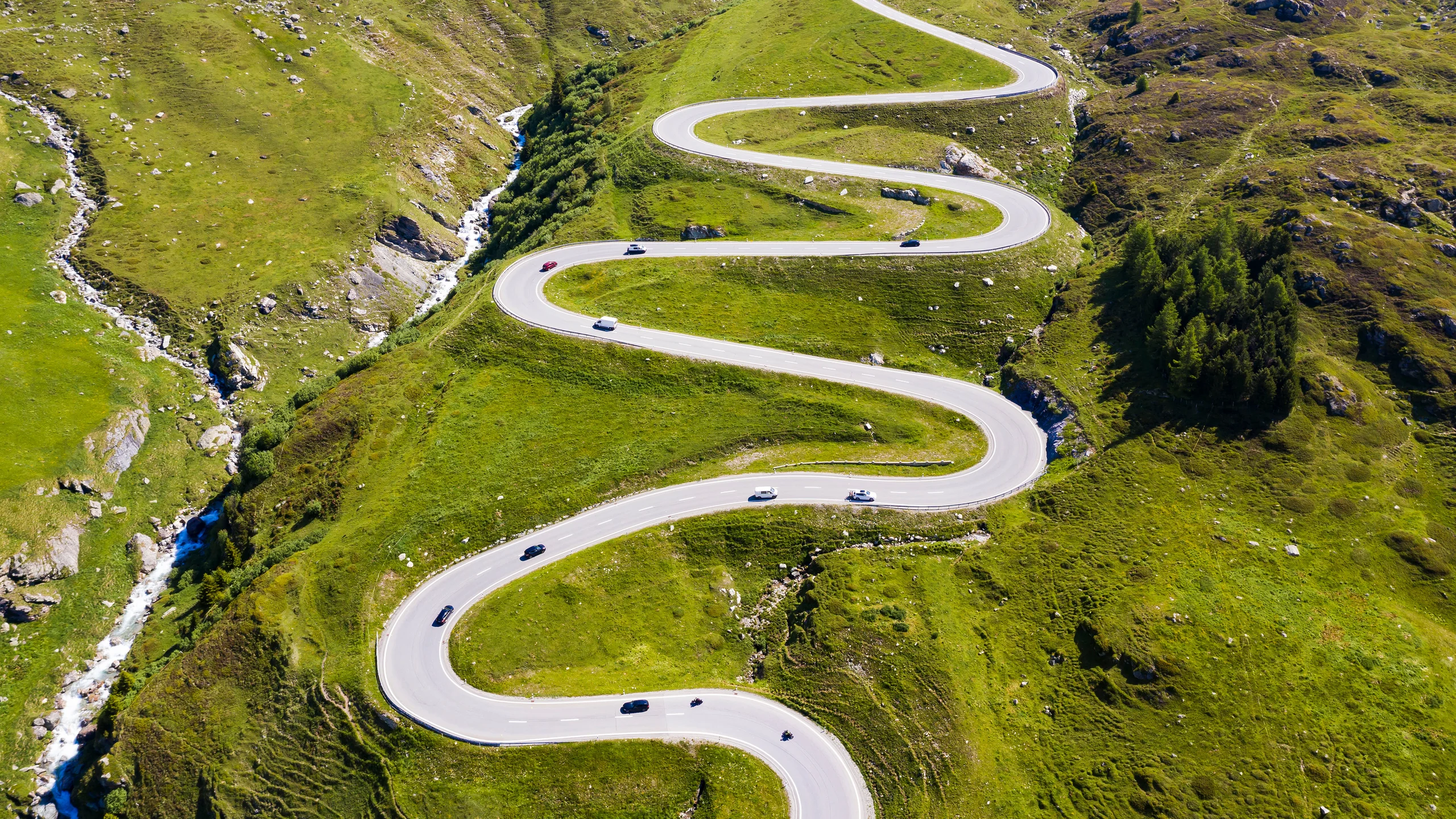
Image: Bing Daily Wallpaper | Winding road on the Julier Pass, Switzerland (© Westend61/Getty Images) | Bing homepage
Open Bing today and a road fills the screen. Instead of heading straight up the slope, it doubles back again and again: climb for a while, make a sudden turn, climb some more, then turn once more. Bing calls the image "The Climb Is Calling."
Who decided where those bends should go? They look like curves drawn by a designer to improve the view. They are not. Every turn is forced by an impersonal physical limit: the gradient. This is the Julier Pass, Julierpass in German and Pass dal Güglia in Romansh, in the canton of Graubünden in southeastern Switzerland, at an elevation of 2,284 meters.
Bing's reason for featuring it is modest. The caption gives only the location, and the copyright link searches simply for "Julier Pass Switzerland," with no anniversary attached. So this story is about the road itself, not a commemoration. One coincidence is still worth noting. According to the Historical Dictionary of Switzerland, the carriage road over the Julier Pass was built between 1820 and 1826. This year therefore marks exactly two centuries since its completion. Bing does not mention that, but it is true.
Why the Bends Are Unavoidable
Begin with the hard limit: a road can only be so steep.
The limit comes from wheels. A wheel needs friction with the road to climb and to brake. Make the slope too steep and heavy vehicles cannot get up; descending brakes heat continuously until they fail. Road-design standards around the world therefore set ceilings on longitudinal gradients. The Montana Department of Transportation's geometric design standards, for example, cap rural collector roads in mountainous terrain at 10 percent; even lower-grade roads are rarely permitted much more. Road data compiled in the German Wikipedia entry for the Julier Pass puts its maximum gradient near 12 percent, already quite aggressive.
What does 12 percent mean? For every meter of elevation gained, the road must travel at least a little more than eight meters forward. At the more usual 10 percent, one meter upward requires ten meters forward.
Apply that number to the Julier Pass. On the east side, the road begins at Silvaplana in the Engadin valley, at 1,815 meters. The pass is at 2,284 meters, a climb of 469 meters. Even if the entire ascent held to the 12 percent maximum, the road would need at least 3.9 kilometers. Yet the mountainside between Silvaplana and the pass is nowhere near 3.9 kilometers in a straight line.
The road, in other words, is longer than the slope. Its excess length has nowhere to go except back on itself, stacked in layers across the same mountainside.
That is the whole origin of the bends. A mountain road does not turn because it wants to wander. It turns because it is too long for the slope that must hold it.
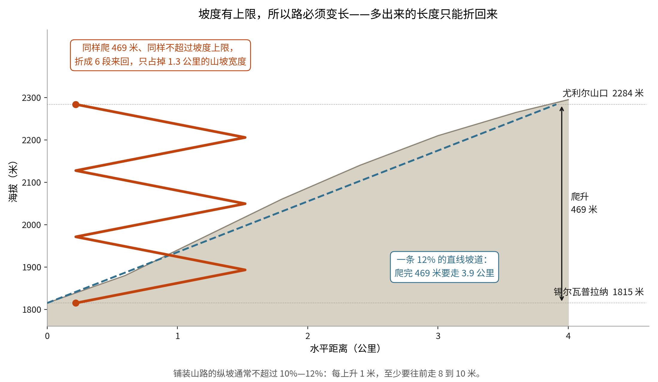
This also explains why the pass has a different character on each side. According to the same road data, the eastern climb from Silvaplana is only 7 kilometers long and averages 6.7 percent: short and sharp. The western ascent from Tiefencastel runs 36 kilometers and averages less than 4 percent: long and gentle. One pass is a sprint from one side and a distance run from the other, because the valley floors lie at very different elevations while the gradient limit remains the same.
Rain on Opposite Sides Goes to Different Seas
The loveliest thing about the Julier Pass has nothing to do with the road.
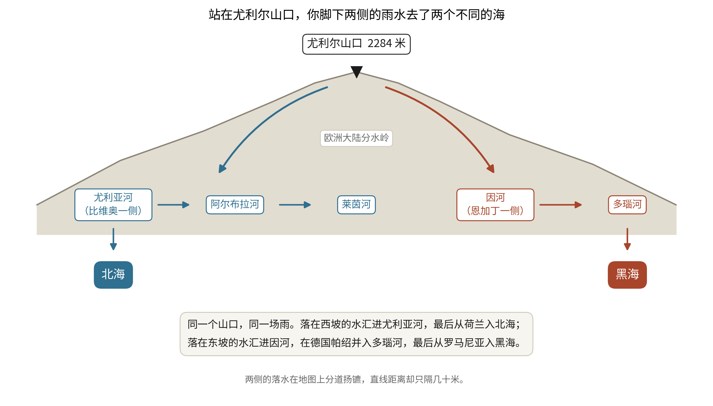
It sits directly on a European continental divide. According to watershed information compiled in the German Wikipedia entry, water falling on the western slope enters the Julia, then the Albula, then the Rhine, and eventually reaches the North Sea through the Netherlands. Water falling on the eastern slope enters the Inn, runs northeast through Austria, joins the Danube at Passau in Germany, and finally enters the Black Sea through Romania.
The same rain falls on both sides of the pass. Two drops perhaps only tens of meters apart set out for different seas, one north and one east, never to meet again.
That is the most compelling identity of a mountain pass: it is both the high point of a road and a boundary for water. People cross; water parts.
Wheels Passed Here Two Thousand Years Ago
The Julier Pass was not selected by a modern highway engineer. People chose it again and again.
The Historical Dictionary of Switzerland reports remains of Roman roads on the north side of the pass and above Sils and Silvaplana, along with large numbers of coins. Romans hauled two-wheeled carts over the steep, rough surface. Two stone columns now standing at the summit are fragments from a Roman sanctuary on the pass, according to the Graubünden tourism authority.
But their story is more complicated than the phrase "Roman ruins" suggests. Documentary leads compiled in German Wikipedia show that writers have mentioned them since the 16th century. When Swiss chronicler Aegidius Tschudi saw them in 1538, they had already fallen and broken in two. Their present upright pose probably dates to the 17th century. Their actual foundations were not excavated until 1934 and 1935. The columns' location is Roman; later hands gave them their posture. As for the sanctuary's exact date or its dedicatee, the available sources provide no reliable answer, so none should be invented.
The name carries a common misconception too. Many guides say Julier derives from Julius Caesar. Etymological research summarized by German Wikipedia calls the name pre-Roman and its connection with Caesar "pure folk etymology." More plausible origins are the Gaulish word julo, meaning "yoke" or "pass," or a Raetian-Illyrian term. A document from 1365 records the name as Berg Julien. The Julia River on the western side shares the pass's name. Neither was named for Caesar; both inherited an old word whose sound we no longer understand.
Romansh and a Twenty-Five-Year Ban on Cars
Graubünden is Switzerland's only canton with three official languages: German, Romansh, and Italian.
Romansh, or Rumantsch, is Switzerland's fourth national language. According to the Swiss Federal Department of Foreign Affairs, a 1938 referendum made it a national language with 91.6 percent approval. It gained official-language status in 1996, giving Romansh speakers the right to use it in administrative matters. About 60,000 people speak it today, nearly all in Graubünden. In 2021, only 0.5 percent of Switzerland's population listed it among their main languages, down from 1.1 percent in 1910. The names at either end of this mountain road - Silvaplana, Bivio, Güglia - grew from this language.
Graubünden also did something remarkably stubborn. According to a history column from the Swiss National Museum, the canton banned all motor traffic beginning on August 24, 1900, and kept the ban for twenty-five years, until June 21, 1925. No fewer than nine referendums were held over the issue. The vote of October 13, 1907, "decisively confirmed the total ban." Drivers heading from Austria to Italy were stopped at the border in Martina. A photograph from 1909 shows a motorcar being pulled by horses through the town of Scuol.
Intriguingly, the Historical Dictionary of Switzerland says the Julier Pass had already been selected in 1923 as Graubünden's motor route across the mountains. Before the canton had fully admitted cars, people had decided that when automobiles eventually entered the Engadin, this was the road they would take. The bends on today's Bing homepage are direct descendants of that decision. This year is the 101st since the ban ended.
The Red Wooden Tower on the Pass
One short-lived and beautiful structure deserves a mention.
From 2017 to 2023, an all-wood red theater tower stood on the Julier Pass. Nova Fundaziun Origen built it under architect Giovanni Netzer. According to Open Doors Engadin, it used 1,220 prefabricated wooden elements, 24,400 screws, and ten support towers, and took only two and a half months to assemble. Its cylindrical form reduced its exposure to snow and wind, and it was said to withstand gusts of 240 kilometers per hour. More than 2,000 meters above sea level, it hosted opera and ballet, including performers from the Paris Opera and the Vienna State Ballet.
Then, as agreed, it was dismantled. When the tower came down in 2023, every wooden element was reused or recovered for energy. It stood for only six years and disappeared cleanly. Published accounts disagree on the cost, some giving 2.5 million Swiss francs and others 3.5 million, so no single figure can be treated as fact.
A Chinese Road Built on the Same Principle
China's best-known example of gradient determining road length is the Twenty-Four Bends at Qinglong, in Guizhou.
The mountain road dates from the war against Japan. According to China Daily, supplies carried into China over the Burma Road had to pass this point on their way to Chongqing. The gradient imposed the same limit and demanded the same solution: 24 sharp switchbacks folded the climb into a small patch of mountainside.
The road was also at the center of a mistake that lasted more than sixty years. In 1943, a US war correspondent took a photograph here: a road stacked in dense Z-shapes across a steep slope, with a column of trucks climbing it. The image circulated around the world and became one of the best-known pictures of China's wartime supply routes. But its location was completely misremembered. China Daily reports that for decades it was assumed to be on the Burma Road; contemporary newspapers variously placed it in Yunnan, India, or Burma. Only in 2002, after years of investigation, did Second World War historian Ge Shuya conclude that the photograph was taken in Qinglong County in southwestern Guizhou, on the Yunnan-Guizhou road extending the Burma Road toward China's wartime rear.
A photograph traveled the world while losing its own home for sixty years. As for the road's exact length, Chinese sources give figures ranging from about 4 to 4.5 kilometers, while their straight-line distances and elevation gains contradict one another. Without an authoritative measurement, no exact number belongs here.
Sources: the Historical Dictionary of Switzerland entry on the Julier Pass; official information from Graubünden Tourism; the Swiss Federal Department of Foreign Affairs' About Switzerland page on Romansh; the Swiss National Museum history column on Graubünden's motor-vehicle ban; UNESCO World Heritage Centre property No. 1276 on the Rhaetian Railway; the Switzerland Tourism page on the Landwasser Viaduct; the Montana Department of Transportation's geometric design standards; Open Doors Engadin material on the Julier Tower; the German Wikipedia entry on Julierpass for road data, documentary leads on the columns, and etymology; China Daily's "The Lifeline of the War of Resistance: Qinglong's Twenty-Four Bends in Guizhou"; the Ili Kazakh Autonomous Prefecture government's notice on the opening of the Duku Highway; and Bing Daily Wallpaper's official image interface.