
A road appears only when the sea falls below a particular height. The Moon decides when that happens.
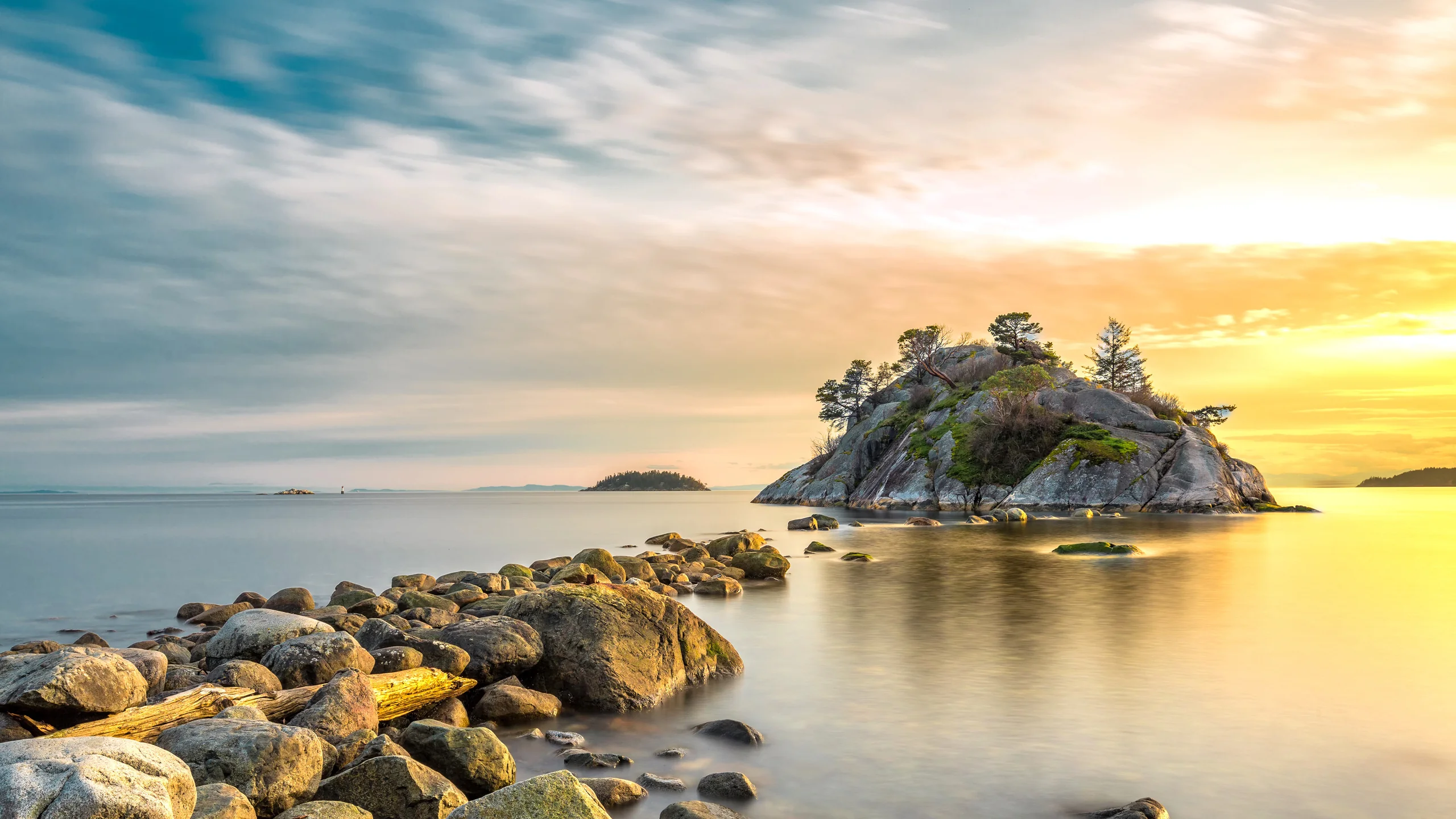
Image: Bing Daily Wallpaper · Whytecliff Park, West Vancouver, Canada (© Aolin Chen/Getty Images)
Open Bing today and the title is simply "Passage Between the Tides." The original English title is plainer still: "A Path Between the Waves."
Bing's official caption explains where the path comes from. When the tide recedes, a rocky passage appears between the park and the small island offshore. A few hours later, the sea takes it back. That is all the photograph tells us, and it would be wrong to invent more.
The phrase worth exploring is "a few hours later."
A Road With Regular Hours
Whytecliff Park lies at the western edge of West Vancouver, British Columbia, beside Horseshoe Bay and facing the entrance to Howe Sound. The uninhabited island opposite is Whyte Islet. Its official coordinates are 49°22'12" north, 123°17'32" west, and the place name was formally adopted in 1961. In 1953, the District of West Vancouver bought the land from a steamship company for C$75,000 and designated it as a park that same year.
Destination Vancouver describes the path simply: at low tide, a "narrow rocky spine" can be crossed to the islet. Its next sentence advises checking the Point Atkinson tide table first, because a late return can mean wet feet or even a swim.
That warning contains the key to the whole story.
The Moon Pulls the Sea Into an Ellipsoid
Imagine the Moon's gravity drawing the ocean slightly toward it. The near side bulges outward. The side facing away from the Moon also bulges, because of centrifugal force. The ocean is stretched into a thick ellipsoid with a rise at each end.
Earth then rotates inside it. Standing still on the shore, you are carried through the ellipsoid twice a day. Passing through a bulge brings high tide; passing through the hollow between the bulges brings low tide. The same beach is covered twice a day and released twice a day.
So far, the pattern is tidy. Real tides are not, for an interesting reason: the Moon is usually not directly above the equator.
The US National Oceanic and Atmospheric Administration explains that tidal "diurnal inequality" comes from changes in lunar declination. When the Moon lies north or south of the equator, the ellipsoid tilts. Earth's rotation carries you first through a thicker part of one bulge, then through a thinner part half a day later. One high tide is higher than the other, and one low tide falls lower than the other. The west coast of North America is a classic region of this mixed semidiurnal tide.
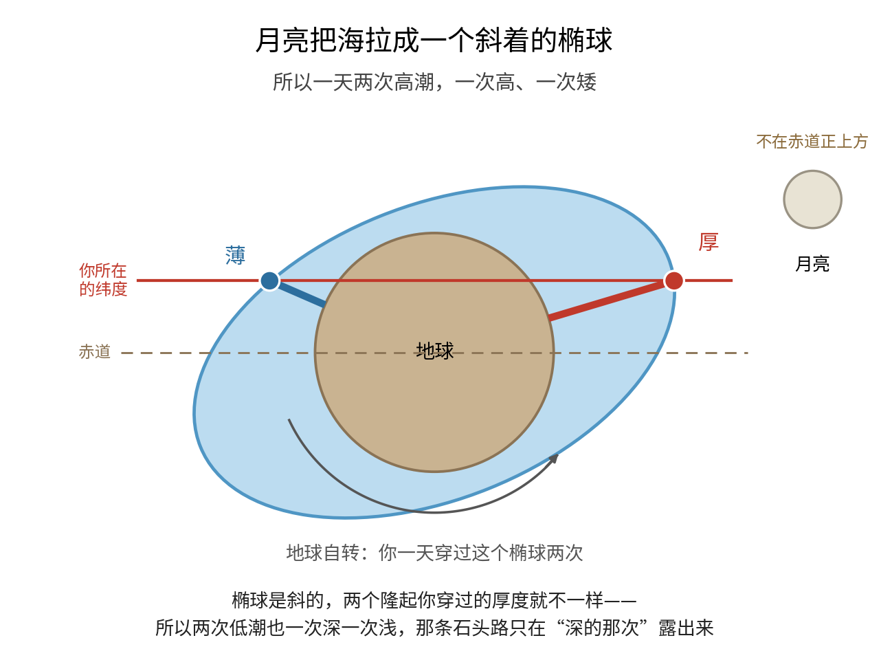
The road's behavior now makes sense. It lies at a particular elevation and appears only when the water falls below it. Of the day's two low tides, the lower one recedes farther. On some days the path appears early and remains exposed for a long time; on others it barely emerges; and sometimes it does not surface at all.
Turning the Marvel Into Numbers
The nearest long-established tidal reference station is Point Atkinson, station 07795, four or five kilometers away as the crow flies and in service since 1897. Two official water levels from the Canadian Hydrographic Service, both measured above chart datum, explain the range. The higher high water at large tides is 5.00 meters; the lower low water at large tides is 0.09 meter.
The difference is 4.91 meters, roughly a story and a half of a building. Average conditions are gentler: a higher high water of 4.46 meters minus a lower low water of 1.24 meters gives 3.22 meters. Recorded extremes run from 5.70 meters to -0.40 meter, a span of 6.1 meters.
That is the path's entire secret. Its elevation lies somewhere between 0.09 and 5.00 meters. The sea travels up and down through those four or five meters every day, more than 300 times a year.
Another Kind of Island Road Is Built by Waves
Coastal geomorphology has a term for a road to an island: a tombolo. Its origin is worth explaining because it has nothing to do with the tides.
An island close to shore blocks oncoming waves. The water immediately behind it becomes a wave-shadow zone. Waves bend around both sides and arrive behind the island with little energy left. Meanwhile, a longshore current carries gravel and sediment along the coast. When it enters the low-energy shadow, it slows and drops its load. Year after year, the deposits can build a road that stitches the island to the mainland.
An important caveat applies here. No official or academic source identifies the Whyte Islet passage as a tombolo. Destination Vancouver calls it a "narrow rocky spine," Bing calls it a "rocky pathway," and the municipal archives avoid a technical term. There is no authoritative conclusion on whether it is wave-deposited sediment or an existing bedrock ridge covered with gravel. The next two examples illustrate the landform category; they do not classify this particular site.
At one end is a completed example. According to official information from Yantai, Zhifu Island in Shandong is China's largest land-tied island. Its four tombolos have a combined length of about six kilometers, range from 500 to 800 meters wide, and stand three to four meters above sea level. They have long been permanent land, built on with roads and houses. The official account of their formation closely matches the process above: alluvium from nearby rivers and beach material entered the longshore sediment flow, while the shelter of Zhifu Island encouraged it to accumulate.
At the other end is one the sea reveals again each day. At Kuibishan in Penghu, low tide exposes an S-shaped gravel path about 300 meters long between the shore and Chiyu. The site is officially managed. Each month, the Penghu National Scenic Area Administration publishes a dry- and full-tide forecast for the Beiliao-Chiyu land bridge. It recommends arriving three hours before the lowest tide and notes that in autumn the path can remain passable for five or six hours after the tide recedes.
Its timekeeping is the most memorable detail. Since July 8, 2014, Nanliao resident Zhao Jinyi has beaten a drum when the path opens and sounded a gong when it closes. Visitors set out to the drum and return to the gong. A 16-character Chinese slogan at the site means: "Beat the drum to set forth; sound the gong to withdraw. Take nothing away but a store of memories."
These are two stages of the same mechanism: one road has finished accumulating, while the sea returns the other each day.
When the Path Appears, Life Forms Horizontal Bands
The receding sea reveals more than a road. Life on intertidal rocks settles into bands by height: a barnacle band, a mussel band, a seaweed band, their boundaries so clear they appear to have been drawn.
Marine ecology offers an explanation with the economy of an aphorism: the upper boundary of each species is set by physical conditions; the lower boundary is set by its neighbors.
Higher up, exposure to air lasts longer and conditions become drier and hotter. Species stop where they can no longer endure the sun and wind. Lower down, moisture and temperature are more comfortable, but competitors, predators and grazers are present. A species stops where it can no longer outcompete its neighbors. Joe Connell's work on barnacles in the 1960s, considered foundational to marine ecology, established this pattern.
The West Vancouver park page lists the underwater life found here: rockfish, lingcod, crabs, sculpins, anemones, sea stars and harbor seals, with occasional wolf eels and giant Pacific octopuses. Sea lions sometimes appear on the beach in summer.
Those last two merit a closer look. The giant Pacific octopus has three hearts, two serving the gills and one the body, and more than 2,100 suckers. Its arm span can reach about 4.9 meters, yet it lives only three to five years, reaching that size through extraordinary growth. The wolf eel is not an eel but a fish with pectoral fins and an eel-like body. It can reach 2.4 meters and live at least 28 years. Powerful jaws crush crab shells and sea urchins. During breeding season, both parents guard as many as 10,000 eggs, and only one leaves at a time to feed.
At low tide, nonswimmers can also see sea stars, carpets of anemones, sea urchins, sculpins, crabs, barnacles and mussels among the rocks. The stewardship rule is to return any lifted rock gently to the place and orientation in which it was found. It is another creature's roof.
Thirty-Three Years Without Taking Anything
In 1993, after efforts by divers, the Vancouver Aquarium and the District of West Vancouver, these waters became a year-round no-take zone. Fish, bivalves, crabs and other invertebrates cannot be taken by any gear or method at any time of year. The restriction remains in the Canadian Department of Fisheries and Oceans' Pacific Region recreational fishing rules for Area 28. This year marks 33 years.
A widely repeated description of the site's status needs calibration. The West Vancouver Archives calls it Canada's first saltwater marine protected area, and the municipal park page uses the same term. Legally, however, it is a fisheries closure under the Fisheries Act, not a marine protected area under the Oceans Act. Canada's first MPA under the Oceans Act was the Endeavour Hydrothermal Vents site, designated in 2003. The distinction is substantive. One says that living things may not be taken from these waters; the other places management of the marine area under dedicated legislation.
There is another protected feature in the channel outside the park. Glass sponge reefs, built by sponges with silica skeletons, lie on the seabed of Queen Charlotte Channel. Fisheries and Oceans Canada lists ten marine refuges and five additional fisheries closures around Howe Sound where bottom-contact fishing is prohibited, including Queen Charlotte Channel. An environmental organization's account says these closures were established in 2019 and 2022.
Hundreds of meters below someone standing on the rocky path is something invisible, and protected by law.
The next ring is larger. On September 15, 2021, UNESCO designated Átl'ḵa7tsem / Howe Sound as Canada's 19th biosphere region. It covers 218,723 hectares, 84% land and 16% sea, under a "mountaintop to seafloor" approach. A biosphere region is not an additional layer of legal protection. It is international recognition of a framework for people and nature to be managed together. The real force of protection still comes from existing parks, fisheries closures and regulations within it.
The area was not always in this condition. The Britannia Mine at the head of Howe Sound was once described as one of the most polluted sites in North America. Untreated acid rock drainage flowed into the sound for about 30 years, until a water-treatment plant formally opened on June 5, 2006. The provincial government called it "a huge improvement" for the marine environment of Howe Sound.
In the following years, records of spawning herring and sightings of top predators returned. Citizen-science surveys from 2017 through 2019 found herring spawning at different sites each year. One event in April 2018 was recorded as the most concentrated spawn in nearly a decade. Pollution treatment and the return of life are separate events, divided by several years, but they did occur in that order.
A Chinese Observer Matched the Moon to the Tides a Thousand Years Ago
The road on Bing's wallpaper poses a practical question: when can it be crossed? Humans have asked it for a long time, and Chinese scholars asked remarkably early.
Dou Shumeng of eastern Zhejiang wrote the Haitao zhi, or Treatise on Sea Waves, during the Tang dynasty. According to a platform of the Chinese Academy of Social Sciences, it is the earliest surviving Chinese monograph on tides. His chart for calculating high- and low-tide times preceded comparable European documents by about 400 years.
Yan Su went further in the Northern Song dynasty. Research by Lu Xiqi of Fudan University's history department says that Yan wrote the Haichao lun, or Treatise on Sea Tides, while serving as prefect of Mingzhou between 1022 and 1024, following ten years of coastal observation. He concluded that full tide occurred "three quarters and seventy-two parts" later each day, equivalent to about 55 minutes and 48 seconds.
The modern figure follows from a lunar day of 24 hours and 50 minutes: the corresponding high tide arrives about 50 minutes later each day.
Yan Su's 11th-century measurement of 55 minutes missed the true value by about five minutes. Newton's explanation of tides through universal gravitation was still more than 600 years away. Yan did not know why, but he had matched the clocks. He also wrote a sentence that made the lunar connection explicit: "The tide always follows the Sun in its westward turn; when the Moon crosses the meridian, the tide reaches full."
Sources: Bing Daily Wallpaper's official caption; the District of West Vancouver park page and municipal archives; Destination Vancouver; official Canadian Hydrographic Service water-level data for Point Atkinson station 07795; Fisheries and Oceans Canada rules for Area 28 and its list of Howe Sound glass sponge reef closures; the Canadian Commission for UNESCO and the Átl'ḵa7tsem / Howe Sound Biosphere Region; NOAA explanations of tidal types and diurnal inequality; the tombolo chapter in Physical Geology at opentextbc.ca; Biology LibreTexts on intertidal zonation; the Alaska Department of Fish and Game page on the giant Pacific octopus; the Oregon Conservation Strategy entry on the wolf eel; the Penghu National Scenic Area Administration's Beiliao recreation page and tide forecasts; official Yantai information on Zhifu Island; Royal National Lifeboat Institution research on tidal safety; China Social Sciences Net and China Science Communication on the Haitao zhi; Lu Xiqi of Fudan University on Yan Su's Haichao lun; and the General Office of China's State Council notice on public holidays in 2026.