
A V-shaped cleft through green hills, a stone that loses its color when baked and regains it under radiation, and a road being slowly eaten by a mountain.
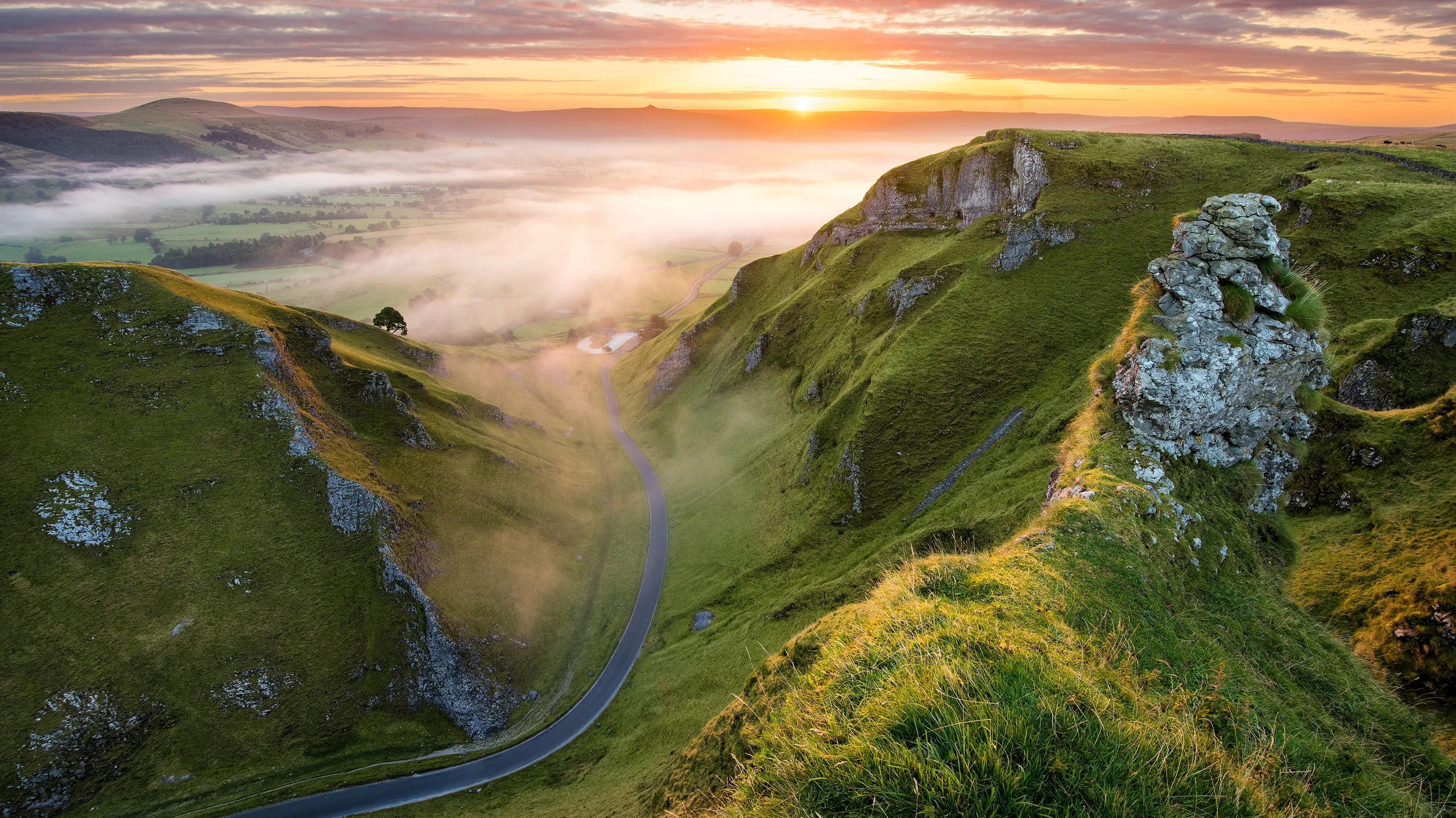
Image: Bing Daily Wallpaper | Winnats Pass, Peak District National Park, England (© Daniel_Kay/Getty Images) | Bing homepage
Open Bing today and you see a hillside split apart. The grass has that rain-soaked green that seems peculiar to England, running up from the bottom of the frame to the foot of the cliffs. The cliffs themselves are gray-white and layered, like a row of books stood on end in the turf. Between them, the gap narrows into the distance until its end disappears.
This is Winnats Pass in the Peak District National Park, west of the village of Castleton in central England. It is about 600 meters long, 300 meters wide at the top and less than 50 meters wide at its narrowest point on the valley floor. The signposted gradient is 20 percent; the measured maximum exceeds 28 percent.
It Was Not Made by a Collapse
The best-known explanation for the gorge says that an enormous cavern once stood here. Its roof collapsed, leaving an open trench.
The story is vivid and intuitive. The surrounding rock is limestone, after all, and several caves large enough to enter by boat lie beneath Castleton. But geologists have rejected it. A field guide published by the Geological Society of London states the matter plainly: there is no evidence that the pass began with the collapse of a cave system.
The real process takes a longer route, and it is much more interesting.
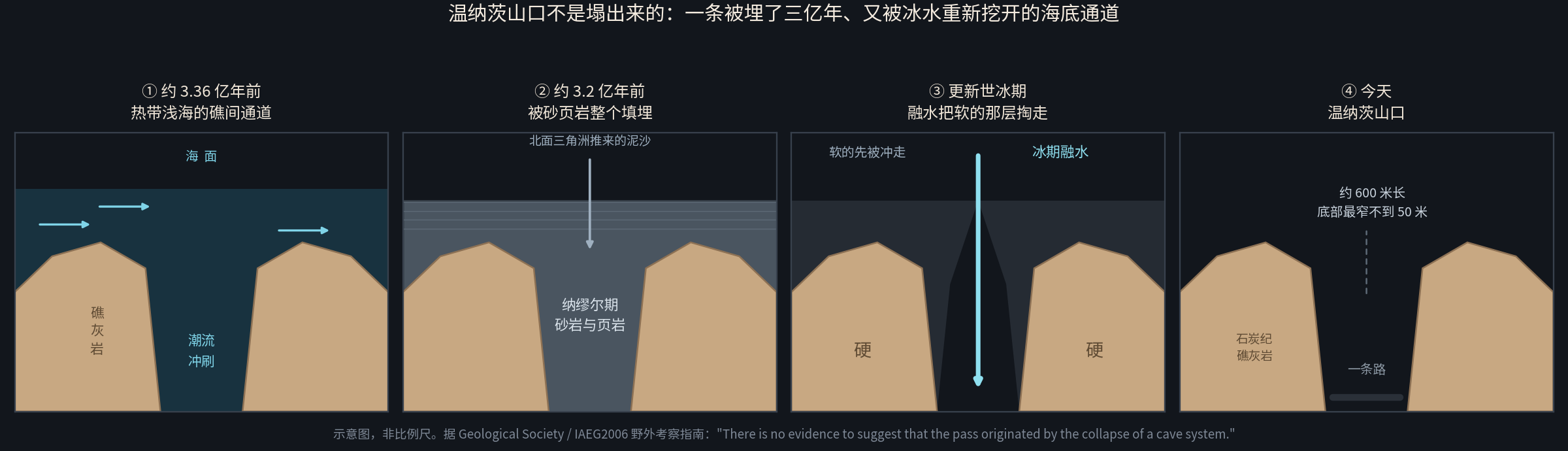
About 336 million to 339 million years ago, this was not England but a shallow tropical sea. Reefs grew on the seabed, not as one continuous mass but as separate mounds known as apron reefs. Tides swept back and forth between two of them, gradually scouring out a channel. That channel was the ancestor of today's gorge.
Then sediment arrived from the north. In the later Carboniferous, a delta advanced southward layer by layer, burying the reefs and their channel beneath sandstone and shale. They remained buried for two or three hundred million years.
Then came the Pleistocene ice ages. Meltwater poured over the ground and began cutting downward. Here the crucial difference emerged: sandstone and shale are soft; reef limestone is hard. Water followed the old channel, washing away its softer fill while leaving the resistant reefs on either side. Once that material had gone, a seabed channel 300 million years old stood open again. This time there was no sea above it, only rain and wind.
The shape of the cleft in today's photograph was set by tides 300 million years ago. Its depth was cut by glacial water hundreds of thousands of years ago. For the two or three hundred million years between, it simply lay underground.
One detail is worth seeing up close. A fan-shaped bed of sediment is exposed on the floor of the pass, debris once washed down from the lagoon behind the reef. A fossil beach lies spread beside the road.
Water Can Drink Stone
There is no river on the floor of the gorge today. Where did the water go?
The answer is visible nearby. Streams flowing south from Rushup Edge behave normally while they cross sandstone and shale. The moment they reach limestone, they disappear underground through openings called swallow holes. They reappear beneath Peak Cavern at the other end of the valley and become Castleton's water supply.
The chemistry is simple. Rainwater absorbs carbon dioxide and becomes mildly acidic. Limestone is mainly calcium carbonate, which acid dissolves. Year after year, water removes a little more rock. Cracks become passages; passages become caves. In limestone country, water does not travel over the stone. It travels through it.
Follow that thought one step farther and you reach Castleton's most famous stone.
A Blue Stone Science Still Cannot Explain
Blue John is a variety of fluorite with blue-purple bands. Chemically, it is calcium fluoride. For more than 200 years it has been cut into bowls, vases and jewelry in Britain.
One often repeated claim says it occurs nowhere else in the world. That needs qualification. Blue-banded fluorite occurs in Belgium's Ardennes, Illinois in the United States, Mexico and parts of China. The accurate claim is this: the specific variety called Blue John comes only from Treak Cliff, a single hill at Castleton. Two mines still work the hill, Blue John Cavern and Treak Cliff Cavern. Mining records reach back to 1757. The older Miller's Mine began around 1745 and may have been the world's first Blue John mine.
Production has changed sharply. Eighteenth-century leases limited output to 20 tons a year. By 1892 it was reportedly down to 3 tons. Today it is about half a ton. In a little over two centuries, annual production has fallen to one-fortieth of its former level.
The more interesting question is not how much is mined, but where the blue comes from.
Its cause is still not settled. Blue John has been studied extensively, yet the origin of its color remains uncertain. One hypothesis is that the color comes not from a pigment but from a physical effect produced by dislocations in the crystal lattice. In other words, it may arise from faults in the stone's internal structure rather than from anything colored inside it.
Two strange experimental facts support that idea. Heat Blue John and the blue disappears. Put the faded stone in a nuclear reactor and irradiate it, and the blue returns.
People have mined this stone for 280 years and turned it into countless bowls. Yet those who extract it, sell it and study it still cannot say exactly why it is blue. The most interesting part of science is often not the answer, but the thing sitting in plain sight that has not yet been solved.
A Road the Mountain Is Slowly Eating
Winnats Pass is narrow, steep and difficult to travel. In 1810, a toll road was built to bypass it, running north across the flank of Mam Tor, where the ground appeared much gentler.
But Mam Tor has another name: the "Shivering Mountain." Its structure is hard over soft. A cap of tough turbidite sandstone rests on weak black shale. The shale cannot support it, so the whole eastern face of the mountain has been sliding downhill. A major landslide occurred 3,200 to 4,000 years ago, and movement has never entirely stopped. Sources give different rates: a field guide reports 150 millimeters a year at the toe and 350 to 500 millimeters within the slide, while another estimate puts the annual average as high as 0.25 meter. Rain is the trigger. Movement accelerates noticeably when monthly winter rainfall exceeds 210 millimeters and the total for the preceding six months exceeds 750 millimeters.
The road built in 1810 began to crack year after year. Derbyshire County Council started systematic records of its deformation in 1907. Major repairs followed in 1912, 1933, 1946 and 1952. Another episode of ground movement tore the surface apart in 1977. In January 1979, the road closed for good, and its route number was later assigned elsewhere.
The result is a neat reversal. The new road was built to avoid the steep, narrow old road through Winnats Pass. A hundred and seventy years later, the mountain consumed the new road and traffic was forced back through the pass. Today the National Trust manages Winnats Pass. Only light vehicles may use it; buses and vehicles over 7.5 tons are prohibited.
The shattered road still lies on the slope of Mam Tor, and people can walk up it. One account describes parts of the route as a scramble over boulders of broken asphalt. The Peak District National Park Authority includes the "Mam Tor landslip" on its official list of stile-free accessible routes. In other words, visiting a road eaten by a mountain is an officially recommended outing.
The Park Itself Was Walked Into Being
The Peak District was Britain's first national park, designated on April 17, 1951, under the National Parks and Access to the Countryside Act passed on December 16, 1949. The year 2026 marks its 75th anniversary.
There is an easy misconception to clear up for readers outside Britain. A British national park is not an uninhabited wilderness in the American sense. About 38,000 people live in the Peak District. It falls within Category V of the International Union for Conservation of Nature, a lived-in protected landscape. It covers about 1,438 square kilometers and receives more than 13 million visits a year; roughly 20 million people live within an hour's drive.
Its right to be walked can be traced to an act of trespass. On Sunday, April 24, 1932, about 400 walkers assembled at Bowden Bridge Quarry in Hayfield and went in groups onto the privately owned moorland of Kinder Scout. Arrests followed that day, and five people were imprisoned. The park authority's own timeline places the event on the same line as the 1949 legislation and the Countryside and Rights of Way Act 2000, though it does not explicitly say the first caused the others.
The official record does not state the lengths of those five prison sentences.
How a Legend Grows Details
One last story about the pass, and about why it is a story.
The familiar version says that in 1758 several miners murdered an eloping couple in Winnats Pass. The man was Allan and the woman Clara. Miners sinking a shaft found their bones in 1768, and a red leather saddle in the Speedwell Cavern museum belonged to Clara.
Castleton Historical Society investigated the story. Its conclusion: there is no contemporary evidence. The earliest written account appeared in a newspaper on April 28, 1788, 30 years after the alleged crime, and it did not name either victim. "Allan," "Clara" and the saddle were added layer by layer by later writers. A dedicated study appeared in the journal Folklore in 2010 under a title that gives away its conclusion: "The Murder in Winnats Pass: The Evolution of a Peak District Legend."
The local historical society ends with admirable candor: what is the truth? Who knows?
The important part of the story is not the murder but the evolution: how, over more than 200 years, a tale acquires one name, then another, then a prop, until it sounds like recorded history. The same thing happens to repeatedly told pieces of "common knowledge," including the claim that this gorge was made by a collapse.
The Chinese Word in the English Geological Lexicon
Ground really can collapse in limestone country. And when geologists around the world discuss the most spectacular form of that collapse, they use a Chinese word.
In 2005, the British Cave Research Association devoted a double issue of Cave and Karst Science, volume 32, numbers 2 and 3, to tiankeng. One paper by Zhu Xuewen and Tony Waltham was titled "Tiankeng: Definition and Description." They defined a tiankeng as an exceptionally large collapse doline formed by the failure of the roof of a great cave chamber, with the immense mass of fallen rock removed by a sufficiently large underground river.
The best part of that definition is the river hidden inside it. A tiankeng is not merely a very large collapsed hole. Without an underground river to carry the rubble away, the hole would fill with its own fallen rock and could never grow. A tiankeng can develop only where collapse and removal happen together. The word, rendered in English-language papers as "heavenly pit," entered the international vocabulary of karst geology. Researchers still debate where the boundary between a tiankeng and an ordinary doline should be drawn.
Such pits are widespread across southern China. In May 2022, a field team from the Institute of Karst Geology at the China Geological Survey found a new one near Long'ao hamlet, Ping'e village, Luoxi township, Leye County, Guangxi. Its maximum depth is 192 meters and its average depth about 139 meters. The opening measures 306 meters east to west and 150 meters north to south. Its volume exceeds 5 million cubic meters, roughly 2,000 standard swimming pools. Great blocks of collapsed rock cover the floor, which also preserves an intact primeval forest. Three large openings remain high in the walls, thought to be relics of caves from an early stage in the tiankeng's development.
In other words, people in England thought their gorge had been made by a cave collapse, but it had not. In Guangxi, a cave truly did collapse into a pit, and the evidence is visible: rubble underfoot and old cave openings in the cliffs overhead.
For the underground-river side of the story, the best example is in Guizhou. On October 24, 2024, the Guizhou Cave Association and the French Federation of Speleology jointly announced that Shuanghe Cave in Suiyang had been surveyed to 437.1 kilometers, keeping its place as the world's third-longest and Asia's longest cave. The figure is the product of 22 joint Chinese-French expeditions since the late 1980s, followed by a 23rd in 2024. The surveyed length grew from 238.48 kilometers to 409.9 kilometers in September 2023, then to 437.1 kilometers. That expedition also discovered a large underground river that may add more than 10 kilometers to the cave.
Teams from two countries have explored one cave for more than 30 years, returning 23 times, and still have not reached its end. Every expedition makes the map a few kilometers longer.
Sources: Geological Society / IAEG2006 field guide; Peak District National Park Authority website, including the park overview, CRoW timeline and 75th-anniversary material; National Trust; roads.org.uk; Treak Cliff Cavern official website; UK Fossils Castleton collecting guide; the Palaeontological Association's Fossil Collecting in the UK; Castleton Historical Society, "Murder in the Winnats Pass"; Folklore 121(3), 2010; National Stone Centre website; British Cave Research Association, Cave and Karst Science 32(2&3), 2005, including Zhu Xuewen and Tony Waltham, "Tiankeng: Definition and Description"; China Geological Survey announcement on the Leye tiankeng, May 13, 2022; Guizhou Cave Association and French Federation of Speleology announcement on Shuanghe Cave, October 24, 2024; Xinhua report on Shuanghe Cave, September 28, 2023; and UNESCO World Heritage List entry 1248, "South China Karst"