
Skogafoss in Iceland, in a five-second exposure.
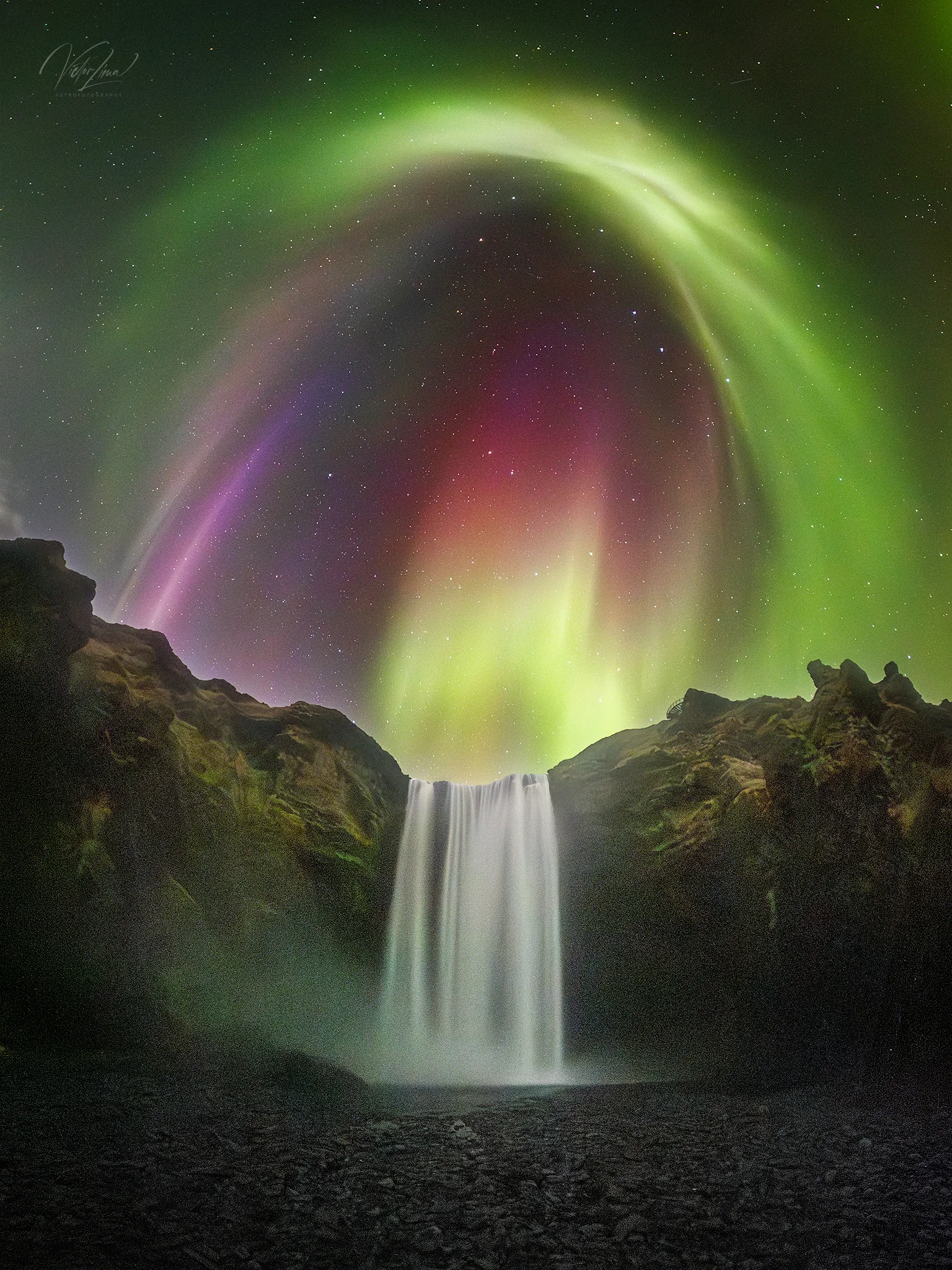
Image: NASA Astronomy Picture of the Day (APOD) | Image credit and copyright: Victor Lima | Today's page
NASA's caption for today's photograph uses one word particularly well.
The editors write that the sky filled with colors that night, colors that appeared to rain down on Iceland's Skogafoss waterfall.
Then the caption moves on. It raises the question of why the lights look like rain, but never answers it.
That is where we begin.
Parallel Lines Always Seem to Converge
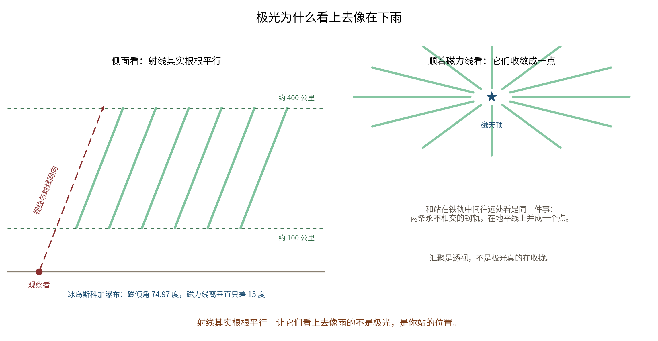
First, something you already know but may never have considered here: parallel lines converge in your field of view.
Stand between two railroad tracks and look into the distance. The rails, though they never meet, merge into one point at the horizon. Walk down a straight avenue and two evenly spaced rows of trees crowd together at the far end. This is linear perspective. The lines have not bent; you are looking along them.
Auroral rays are just such a set of parallel lines.
The US National Oceanic and Atmospheric Administration's aurora tutorial explains that a seemingly continuous auroral arc is really a bundle of tall rays that together resembles a hanging curtain. Why are the rays parallel? Because they align with Earth's magnetic field lines. At high latitudes, those field lines plunge almost vertically toward the ground, and the rays stand along them.
Their scale matters even more. The US National Centers for Environmental Information describes auroras as highly structured ribbons: sheets only a few hundred meters thick that can extend hundreds of kilometers through the atmosphere. An educational poster from NASA's Goddard Space Flight Center places their luminous altitude at 100 kilometers to more than 400 kilometers.
Put those numbers together and a single ray is both extraordinarily thin and extraordinarily long, with an aspect ratio of roughly one thousand to one. Proportionally, it is much slimmer than a pencil.
Perspective must dominate the way our eyes see an object like that. When your line of sight aligns with the rays, they appear to converge at a single point, as though light were pouring straight down from the sky.
The American Meteorological Society's Glossary of Meteorology defines an "auroral corona" in a single sentence that captures the whole idea: in any sufficiently complex rayed aurora, the rays appear to converge into a fan or corona when viewed along the magnetic field lines.
Notice the qualification: it does not say simply to look up. It says to look along the magnetic field.
At Skogafoss, the Magnetic Field Is Only 15 Degrees From Vertical
Which way does the magnetic field point in Iceland?
You can calculate it yourself. The British Geological Survey provides a public geomagnetic model interface for querying the direction of the field at any coordinates. Enter Skogafoss, 63.53 degrees north and 19.51 degrees west, for April 2025, and the result is:
A magnetic inclination of 74.97 degrees.
In other words, the field lines there meet the ground at an angle of 75 degrees, only 15 degrees from vertical. In the same data, the vertical component is 3.7 times the horizontal component. That is the plainest possible way to say that the local magnetic field plunges almost straight into the ground.
In Iceland, then, the "magnetic zenith" lies in a small patch of sky about 15 degrees north of true overhead and another 10 degrees to the west. Point a camera there and the rays converge in the frame.
Skogafoss faces south, with water falling from a cliff to the north. Stand directly before the waterfall and look up, and your gaze naturally sweeps near the magnetic zenith. The "rain" in this photograph owes half its appearance to the aurora and half to the direction of the cliff.
Five Seconds Is a Light Meter in Its Own Right
NASA's caption includes another number: this was one five-second exposure, not a stack.
That number says more than it seems to.
The Royal Observatory Greenwich recommends that amateur photographers begin at 15 seconds, ISO 800 and f/2.8, while warning that an exposure that is too long turns the aurora into "a green fog" rather than sharply defined bands. Canon's official tutorial suggests f/2.8, ISO 1600 and 20 seconds as a starting point, adding that only a fast-moving aurora calls for reducing the shutter speed to five to ten seconds or less to freeze its motion.
Placed against those benchmarks, five seconds tells us two things at once.
First, the aurora was bright. The exposure admitted only one-third or one-quarter as much light as usual, yet the glow still filled the frame and saturated the image with purples and reds.
Second, it was moving quickly. A languid green arc would not require five seconds. The photographer needed a short shutter because the rays were surging on the scale of seconds, pinning the strands of "rain" in place. A long exposure would have blurred them into green mist.
One exposure setting tells us what the sky was doing.
(NOAA did report a severe G4 geomagnetic storm on April 16-17, 2025. But NASA gives only "April 2025," not a precise date, so there is no way to confirm that the photograph was taken that night.)
Now Look Down
We have discussed the sky. Now consider the ground, because the truly ancient thing in this photograph occupies its lower half.
Skogafoss is about 60 meters high and 25 meters wide, according to Iceland's nature conservation authority. The official site of the UNESCO Katla Global Geopark instead gives 62 meters high and 15 meters wide. That is a 67 percent difference in width, and both are official sources, so both figures belong here. In 1987, the waterfall, the Skoga River and their surroundings were designated an Icelandic natural monument covering 1.84 square kilometers.
The real question is: Where did this cliff come from?
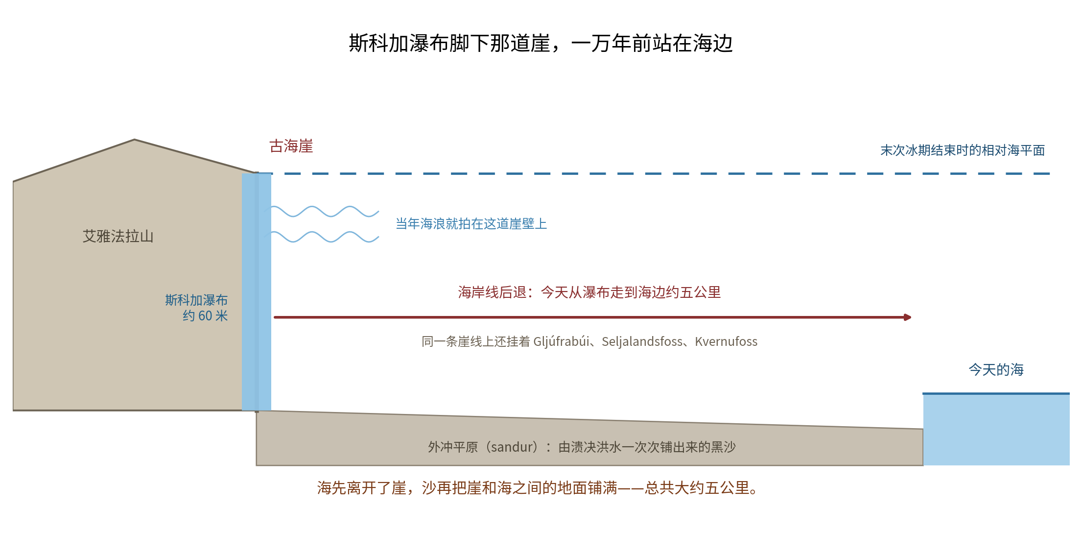
Iceland's nature conservation website gives the answer in one Icelandic sentence that translates directly as: the rock layer over which the waterfall descends is an old sea cliff.
A sea cliff. Waves once struck this wall of rock.
The geopark in southern Iceland supplies the fuller explanation. Around the end of the last ice age, relative sea level here was far higher than it is today. Wave after wave eroded the foot of the Eyjafjoll range and cut this escarpment. Sea level later fell, and lowland gradually accumulated in front of the cliff, leaving the old sea cliff inland.
The sequence matters: first the sea left the cliff, then sand filled the ground between cliff and sea, layer by layer.
A Whole Row of Waterfalls Hangs From the Same Old Coastline
Once you know this, Iceland's south coast becomes a different landscape.
From west to east are Gljúfrabúi, 40 meters high and hidden in a cleft, itself a protected natural monument; Seljalandsfoss, 62 or 65 meters high, with a path behind the falling water; Kvernufoss, 1.5 kilometers east of Skogafoss; and then Skogafoss.
Four waterfalls line up from west to east over tens of kilometers.
They hang from the same coastline, more than ten thousand years old.
You can see the line on a map: the ruler-straight escarpment at the foot of Eyjafjoll. Today, the walk from Skogafoss to the sea is about five kilometers. That figure is widely repeated, but no official geological source for it was found; it can be measured directly on a map.
Five Kilometers of Land, Laid Down by Floods Lasting Only Hours
How did the plain in front of the cliff grow? The answer is far more violent than sediment slowly accumulating.
The outwash plains of Iceland's south coast, called sandur in Icelandic, were built mainly not by the gradual work of ordinary meltwater but by repeated glacial outburst floods triggered by subglacial volcanic eruptions, or jökulhlaups. Their peak discharge can exceed 100,000 cubic meters per second, with a sediment concentration above 35 percent.
The most startling figures come from Katla's 1918 jökulhlaup. Research puts the peak discharge at more than 300,000 cubic meters per second. The main flood crest lasted about five or six hours, followed by roughly two weeks of lesser flooding. The event deposited about 950 million cubic meters of material above sea level. Iceland's southernmost headland was temporarily pushed about four kilometers out to sea, before waves rapidly eroded it back.
Another study offers an even clearer comparison. One outburst flood moved as much sediment as 70 to 80 normal summers of meltwater combined, while discharge surged from about 400 cubic meters per second to about 100,000.
An official Katla Geopark page about another nearby black-sand plain says that its coastline has advanced roughly 2.5 kilometers southward since 1660. The sand is about 60 meters thick in one place and 120 meters in another. It is black because it contains large amounts of volcanic glass.
So the clearest one-sentence account of Iceland's south coast is this:
The plain did not grow slowly. It was laid down all at once by a handful of floods, each lasting only hours.
One aside about 2010: on March 21 that year, the flank eruption at Fimmvörðuháls began along the hiking route at the headwaters of the Skoga River. On April 14, the summit crater beneath Eyjafjallajokull began erupting, in the event that shut down airspace across Europe. The Icelandic Meteorological Office recorded the resulting flood, laden with volcanic debris and blocks of ice, moving as fast as 20 kilometers per hour. Its flood-warning system monitored two things: water level and electrical conductivity.
The Chest Behind the Waterfall, and the Ring That Really Exists
Icelanders tell a story about Skogafoss.
The thirteenth-century Book of Settlements records a man named Þrasi as the first settler at Skogar. He was said to know magic and to direct floods by sorcery. A story collected by an Icelandic folklorist in 1862 added the next detail: Þrasi buried a chest of gold and silver beneath Skogafoss.
Around 1600, a young man climbed behind the waterfall, caught hold of the chest and tried to pull it free. The chest broke apart. Everything fell back into the waterfall except one ring.
The best part of the story is that the ring is real.
The Skogar Museum's website records its history precisely. The ring served as the knocker on the door of Skogar Church until that church was decommissioned in 1890. It then became the knocker on another church until a new one was built in 1961. Today it is in the museum.
A real object was adopted by an invented story.
The treasure actually buried beneath the cliff is the sea that stood there ten thousand years ago.
China's Old Coastline, Fifty Kilometers From the Sea
China has counterparts to Iceland's retired sea cliff, and more than one.
Along the western shore of Bohai Bay are shell ridges, embankments of shells and shell fragments, each preserving an old coastline where it once stood.
Popular-science material from the Ocean University of China says that five shell ridges have been identified along the western shore of Bohai Bay, each extending intermittently for hundreds of kilometers and measuring about two to four meters thick. Their dates fall into a clear sequence. The innermost, the fifth ridge, formed 6,700 to 5,530 years ago and lies about 50 kilometers from today's coast. Moving outward, the others date to 5,050-4,070 years ago, 3,300-3,100 years ago, 2,300-1,200 years ago, and about 900 years ago. The outermost follows the modern shoreline.
Put the two coasts side by side:
Southern Iceland pushed the sea back a few kilometers over more than ten thousand years. The western shore of Bohai Bay pushed it back about fifty kilometers in less than seven thousand.
One relied on volcanic sand carried down by glacial outburst floods; the other on loess carried down by the Yellow River. Different machinery, same work.
These shell ridges are not trivia. They are protected by the state. The Tianjin Ancient Coast and Wetland National Nature Reserve was established with the approval of China's State Council, principally to protect rare remains of ancient coast formed by shell ridges and oyster reefs. Hebei's Huanghua Ancient Shell Ridge Provincial Nature Reserve was approved by the provincial government in September 1998. It covers 117 hectares and contains six ancient shell ridges. One source says five and another six because they count different areas: one describes the entire bay, the other the ridges within the reserve. How many there are depends on where you draw the boundary.
Sources: NASA Astronomy Picture of the Day for August 27, 2026; the US National Oceanic and Atmospheric Administration's aurora tutorial; the US National Centers for Environmental Information's aurora overview; NASA Goddard Space Flight Center's educational aurora poster; the American Meteorological Society's Glossary of Meteorology, "auroral corona"; the British Geological Survey's WMM2025 geomagnetic model web service; official aurora photography guides from the Royal Observatory Greenwich and Canon; Iceland's nature conservation authority, nattura.is, on Skogafoss; the Katla UNESCO Global Geopark website; South Iceland's tourism authority's geopark waterfall pages; Maizels, "The Origin and Evolution of Holocene Sandur in Areas of Jökulhlaup Drainage, Iceland"; Tómasson, on the 1918 Katla jökulhlaup, Annals of Glaciology (1996); Hine and Boothroyd, Journal of Sedimentary Petrology (1978); Jökull, vol. 55, on prehistoric jökulhlaups in Markarfljót; the Icelandic Meteorological Office's pages on the 2010 eruption and flood warning; the Skogar Museum's "Ring of Þrasi"; the Icelandic Meteorological Office's aurora forecast and guide; Ocean University of China, "Shell Ridges: Marks of Ancient Coastline Change"; Acta Geoscientica Sinica (2000), on the subdivision and chronology of the second shell ridge along western Bohai Bay; Tianjin Municipal People's Government Order No. 36; and the Hebei Department of Ecology and Environment's page on the Huanghua Ancient Shell Ridge reserve.