
A row of wooden boxes and a conveyor belt that never stops moving.
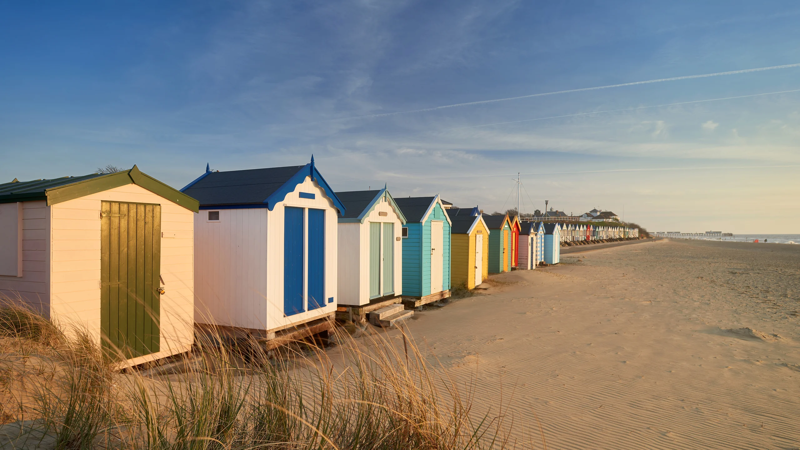
Image: Bing Daily Wallpaper | Traditional beach huts, Southwold, Suffolk Heritage Coast, England (© stevendocwra/Getty Images) | Bing homepage
Open Bing today and a row of wooden boxes stands shoulder to shoulder by the sea. Pink, blue and cream, with peaked roofs and closed doors, they continue beyond the edge of the frame. They look settled, respectable and untroubled, as if they have stood there for a century and intend to remain for another.
This is Southwold, in Suffolk on England's east coast.
Begin with something the photograph does not readily reveal: these huts stand so securely because the sand beneath them came from someone else's shore.
The Sand Did Not Begin Here
First, a set of figures from the UK Environment Agency's long-term measurements of the Suffolk coast.
At Easton Bavents, 1.5 kilometers north of Southwold, the cliff retreats by 2.1 meters a year. Farther north at Covehithe, the retreat is 3.1 meters on one survey line and 3.8 on another. At a section called Boathouse Covert farther north still, the agency gives a rate of 5.7 meters a year - the fastest anywhere on the Suffolk coast, according to its report. Since 1992, the sea has advanced roughly 100 meters inland there.
Now consider Southwold itself. At Gun Hill, where the beach huts stand, the Environment Agency measured annual growth of 1.9 meters.
One shore is collapsing while another grows. These are not two coincidences but one process.
The agency's report says plainly that the rapidly eroding cliffs at Covehithe and Easton Bavents are "supplying sediment to the coastal system," feeding the beaches at Southwold to the south.
Waves rarely strike a beach head-on. They usually arrive at an angle. The swash runs diagonally up the shore, but the backwash returns straight down, following the steepest slope. Every wave therefore carries the sand a small step along the coast: diagonally up, straight back, then diagonally up again. One small step at a time, thousands of times a day. Geographers call this longshore drift.
Along this stretch of coast, the net movement of sand is from north to south.
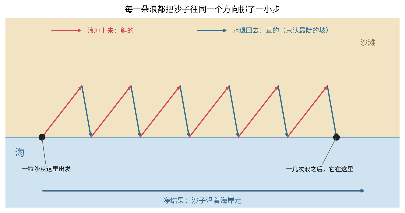
Every grain beneath those colorful huts was therefore once part of a cliff farther north. It was not carried here in one trip. It walked here - a few kilometers over several decades, one small step at a time.
Why Did It Stop Here?
Because someone placed a barrier in its path.
The north pier at Southwold Harbour reaches into the sea. The Environment Agency calls it "the terminal groyne to sediment drift from the north." Another coastal project in 2006 added new groynes with the stated purpose of maintaining a higher beach level.
The conveyor belt is interrupted at Southwold. Houses to the north fall toward the sea while the beach here thickens, leaving this row of huts high and dry.
There is a moral dimension to that exchange, but it is not one to settle here. The physics itself is stark: the stability of these huts is purchased with the collapse of their neighbors' cliffs.
Nor is this peculiar to Britain. China's Ministry of Natural Resources reported in its 2023 China Sea Level Bulletin that erosion intensified that year along some monitored sections of the Liaoning, Shandong, Jiangsu and Hainan coasts. Sandy coasts retreated by an average of roughly 2.7 meters. Set beside the numbers from England's east coast, it is exactly the same order of magnitude: the same ocean, governed by the same physics.
Their Earlier Life: Beach Huts Once Had Wheels
Now consider the boxes themselves.
Their ancestors were bathing machines.
Victorians wanted to enter the sea, but their standards of propriety allowed no one to see them change and scarcely allowed them to be seen walking across the sand in bathing clothes. The answer was a small wooden hut on wheels. You entered on shore and closed the door; a horse pulled the entire hut into the sea. Inside, you changed at leisure, then descended steps from the side facing away from the beach and entered the water. No one saw you at any point.
An official interpretation panel from Tendring District Council in Essex describes a bathing machine as "a small wooden hut on wheels" in which bathers could change into swimwear with the period's expected modesty, then descend steps directly into the sea. A contemporary account from 1805 also describes a "modesty hood" at the front - a large canopy that could be lowered to the water so that a bather remained hidden from public view while stepping down from the machine.
The apparatus stayed popular for a long time. In the National Heritage List for England, Historic England's listing for Cromer's beach huts includes a firm date: "By 1779, bathing machines were advertised for hire at Cromer." That was 247 years ago.
Then the rules relaxed. Sex-segregated sea bathing ended in Britain in 1901. People discovered that they no longer needed a horse-drawn box to conceal their path into the water. Bournemouth opened Britain's first municipal beach hut in 1909. Cromer's permanent wooden huts followed in 1912. Historic England calls them "among the earliest surviving beach huts and forerunners of the modern timber beach hut," adding that huts this early are extremely rare, with only three other listed examples. By about 1914, bathing machines had largely vanished from British seaside resorts.
The wheels came off. The box remained.
Without its wheels, the box ceased to be a device for hiding. It became somewhere to sit in the doorway, drink tea, watch the sea and store folding chairs. The same wooden container acquired the opposite purpose: once it meant "do not let anyone see me"; now it meant "sit here and look."
The Southwold Beach Hut Owners Association says that 12 old-fashioned "bathing huts" still survive near the pier and are rented by the day in summer.
A Wooden Shed Without Water or Power, and the Sand Beneath It
Southwold now has 266 privately owned beach huts, more than 50 of which their owners rent out.
One distinction is easy to miss: the hut is private property, but the sand beneath it is not. East Suffolk Council's official guidance is explicit: "Southwold beach huts are privately owned and sit on sites leased from the Council."
The council's fee schedule for 2025/26 puts a public price on that patch of sand: £723.24 a year for a premium site, £578.81 for a standard site, plus £764.03 for a new beach-hut license. At the bottom of the same document comes another sentence: there are currently no vacant sites.
As for the hut itself, a local news report advertised one on the promenade for £175,000. (Only the report's headline was available for verification, so its year and details should be treated as a media report rather than firm data.)
It is a wooden shed without running water or electricity, and regulations do not allow anyone to stay overnight. A model beach-hut license elsewhere in East Suffolk says the hut may be used only from 5 a.m. to midnight, must be locked between midnight and 5 a.m., and may not be used or occupied during those hours. Yet such a hut can cost as much as a home. The sand beneath it rents for a little over £500 a year, provided you can reach the head of the waiting list.
You can buy the box. You cannot buy the sand.
About the Colors
It would be satisfying to explain why these huts are painted pink, blue and cream. Perhaps the colors helped owners find their hut in the fog, or perhaps they came from some seaside tradition.
No reliable explanation appears to exist.
Historic England's educational image library offers only a literal description of similar huts: "a row of brightly coloured beach huts along the seafront." It does not explain the colors. Neither does the National Trust. Studies of British seaside history stop after descriptions such as "candy-colored" and "toy-like."
No authoritative source offers a practical reason.
The most honest answer, then, is that no one knows why; people simply painted them this way. Some customs need no functional origin. They look good, and for more than a century that has been reason enough.
A Lighthouse Built in the Middle of Town
Beyond the photograph, Southwold has another peculiar sight: a lighthouse standing neither on a clifftop nor a headland, but among houses in the middle of town, its white tower rising through the rooftops.
Trinity House gives a reason, and once again it is erosion.
Three fixed lights once stood on the cliffs at Southwold. Severe coastal erosion was overtaking Orford Ness to the south, so work began in 1887 on a new lighthouse placed on reliable ground in town. First lit on September 3, 1890, it replaced the three cliff lights. The tower is 31 meters tall, the light stands 37 meters above mean high water, and its range is 24 nautical miles. It was electrified and automated in 1938.
(Tomorrow, September 3, is the 136th anniversary of its first light. That is not why Bing selected this photograph today - no relevant commemoration falls on today's date in Britain, and Bing's English edition offers only a six-character search label naming Southwold and Suffolk. The timing is only a coincidence.)
Six days after it was first lit, the lighthouse caught fire and its burner was destroyed. The official Trinity House page gives the cause without ceremony: the new lighthouse keepers were inexperienced.
A lighthouse moved into town to escape erosion set itself on fire during its first week. Some disasters have nothing to do with the sea.
Today, This Beach Has No Lifeguards
One verifiable detail: RNLI lifeguards patrol Southwold North Beach from May 25 through September 1, from 10 a.m. to 6 p.m. each day.
Today is September 2, the first day since summer when North Beach has no lifeguards.
The Royal National Lifeboat Institution's guidance is direct. A red flag means no swimming: "If the red flag is flying, the water is dangerous and under no circumstances should you enter." An orange windsock means no inflatables. Do not climb groynes or rocks, and keep away from pier pilings.
Another point is worth remembering. Research published jointly by the RNLI and Bangor University in April 2025 found that about 15% of people in the UK and Ireland - roughly ten million - had been cut off, or nearly cut off, by the tide in their lifetime. Only half checked tide times before setting out, and only 24% could interpret a tide table correctly. Six in ten people who had been trapped said they were surprised by how quickly the tide came in. Over the previous decade, the RNLI responded to 7,971 tidal cut-off incidents and saved 452 lives.
RNLI water safety education manager Gabbi Bachelor offered one piece of advice: check the tide times at the start of the day, watch the incoming water, and leave enough time to return.
If you do fall into the water, the RNLI teaches one action before swimming: float. Relax and try to breathe normally. Tilt your head back so that your ears enter the water and use your hands to help you stay afloat. Once your breathing is under control, call for help or swim to safety.
Sources: UK Environment Agency, Suffolk Coastal Trends Report (RP022/S/2011) and Southwold to Benacre Dunes Coastal Morphology Report (RP016/S/2010); National Heritage List for England, Historic England (Cromer beach huts, list entry 1408235); Trinity House's official Southwold Lighthouse page; UK government and Natural England guidance on Heritage Coasts; East Suffolk Council's beach-hut page and 2025/26 fee schedule; Tendring District Council's interpretation panel on bathing machines; Southwold Beach Hut Owners Association; Visit Southwold beach information; RNLI beach-safety guidance and its April 2025 tidal cut-off research; UKHO ADMIRALTY EasyTide; China's Ministry of Natural Resources, 2023 China Sea Level Bulletin.