
The Moon's edge is not a smooth arc. In the final moment before totality, sunlight leaks between its valleys to make a diamond.
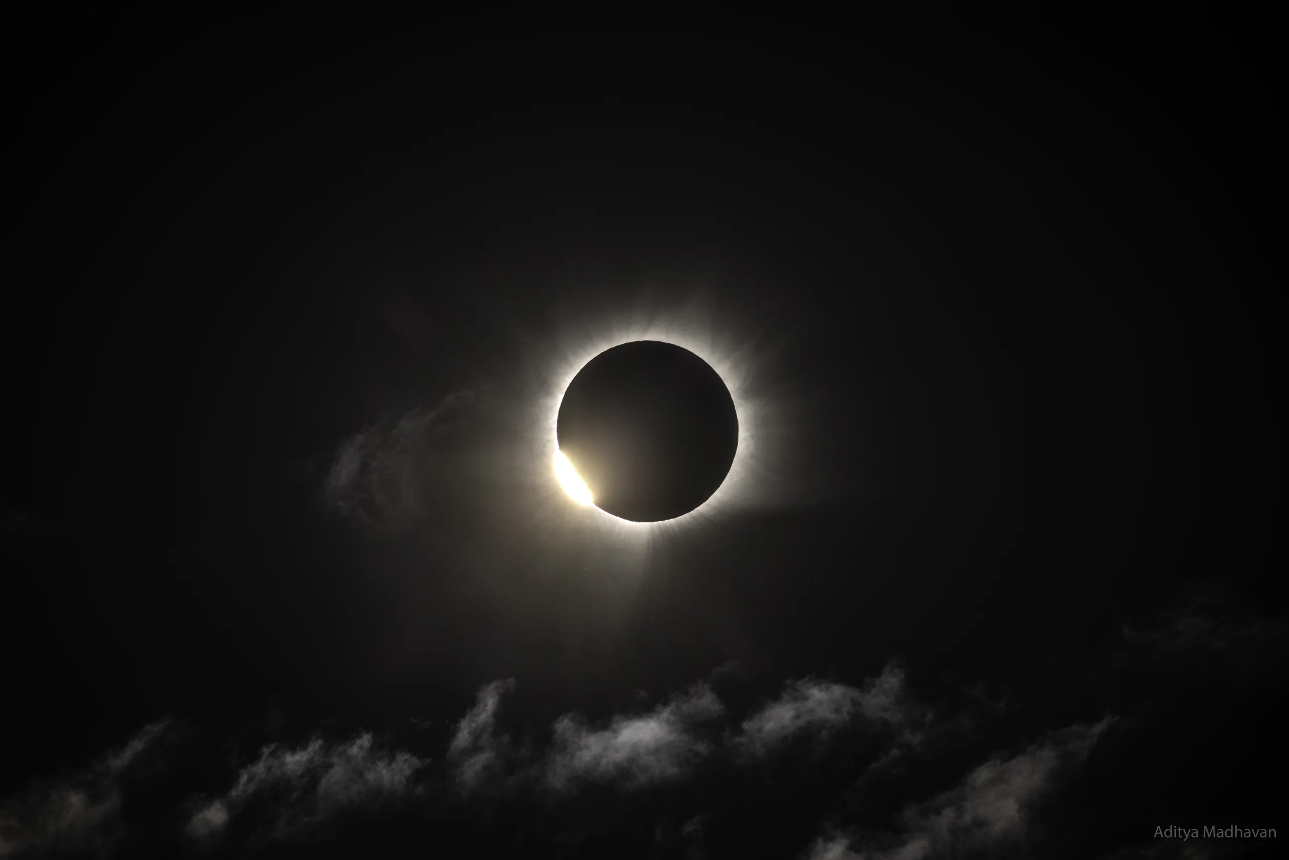
Image: NASA Astronomy Picture of the Day (APOD) | Image credit and copyright: Aditya Madhavan | APOD page
Begin with the photograph's metadata, because it tells a story of its own.
71.07055 degrees north, 27.71252 degrees west. 17:33:26 UTC.
According to APOD, the photographer maneuvered by sea around bad weather, came ashore at Rype Fjord on Greenland's east coast and pressed the shutter at those coordinates. The clouds happened to part there, at nearly the first point along the entire path of totality where the weather began to clear. This may therefore be one of the world's earliest unobstructed images of this total solar eclipse.
And 17:33:26 is worth calculating separately.
Six Seconds
Using the official path table maintained by Fred Espenak at EclipseWise, a calculation places the coordinates only about 16 kilometers from the centerline, almost exactly in the middle. The midpoint of totality there was around 17:34:40 UTC, which puts the start of totality, or second contact, at about 17:33:32. These figures are derived estimates, with uncertainties on the order of 10 seconds and several kilometers.
In other words, the shutter opened about 6 seconds before totality began.
That matches APOD's own wording. It calls the photograph one of "this eclipse's transient diamond rings" and describes the magnificent corona emerging as totality was about to begin.
What exactly was happening in the sky at that instant? That is the whole subject of this story.
The Moon's Edge Is Not a Smooth Arc
Children draw the Moon as a circle. In photographs it looks like one, too.
But the Moon's edge is jagged. It has mountains, crater walls, valleys and clefts.
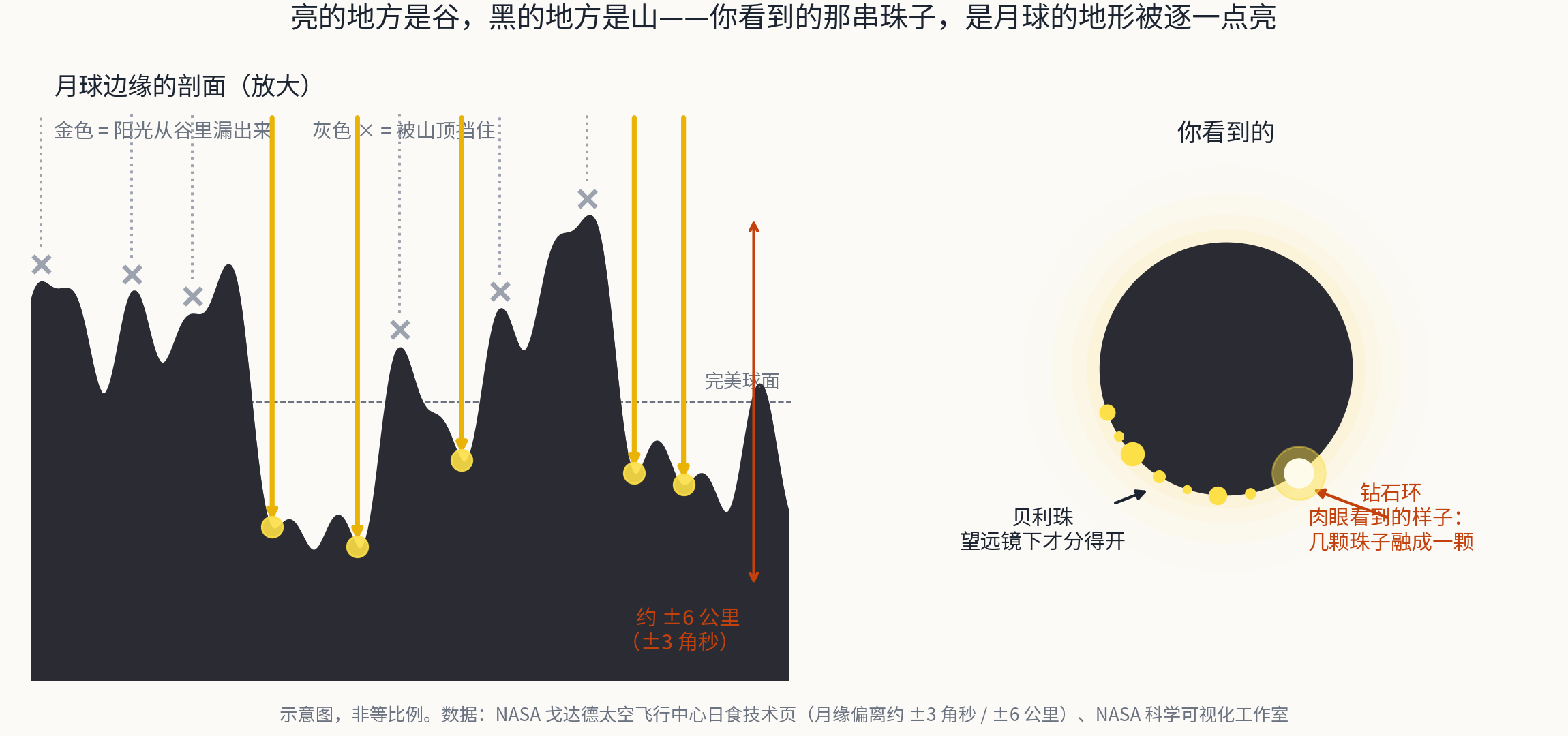
How deep are those irregularities? NASA Goddard Space Flight Center's technical eclipse page gives a figure: the lunar surface departs from a perfect sphere by about +/-3 arcseconds, or nearly +/-6 kilometers. At the Moon's mean distance of 384,400 kilometers, 1 arcsecond equals 1.863 kilometers. For scale, Tycho Crater alone is 4,700 meters deep, and its central peak rises 2,400 meters above the crater floor.
Now connect that terrain to an eclipse.
During a total solar eclipse, the Moon passes in front of the Sun. Just before the Sun is completely covered, the remaining sunlight does not leak uniformly around the edge. It can pass only through the low places along the lunar limb: valleys and gaps between crater walls. Mountains block the light; valleys leave it visible.
The result is a string of separate bright points along the Moon's black outline. They are called Baily's beads. NASA's Scientific Visualization Studio defines them neatly as the bright points of sunlight that shine through lunar valleys along the Moon's profile during an eclipse.
When only the final sliver of sunlight remains, its brilliance overwhelms everything around it. Combined with the halo of the emerging corona, the image looks like a ring set with a diamond.
A diamond ring is therefore a view of a particular valley 380,000 kilometers away. That beam of sunlight is passing straight through it.
The More Radical Version: The Moon's Shadow Is Not an Ellipse
NASA made an even more striking version of that point in a 2017 news release.
Eclipse diagrams usually show the Moon's umbra falling on Earth as a smooth ellipse. But when NASA Goddard visualization specialist Ernie Wright recalculated it with elevation data from the Lunar Reconnaissance Orbiter (LRO), he found something different:
The shadow is not truly an ellipse. It is an irregular polygon with gently curved edges, and every edge corresponds to a valley along the lunar limb.
Consider what that means. The dark patch on Earth is hundreds of kilometers wide, yet every corner in its outline comes from a particular mountain on the Moon. The Moon projects its own topography onto Earth's surface at full scale.
Wright said that such a visualization had not been possible a decade earlier. It emerged from increased computing power combined with remote-sensing data from LRO and the Shuttle Radar Topography Mission. Wright also made NASA's official map for the August 12, 2026, eclipse.
A Diamond Ring Is Not Simply "the Last Bead"
Many accounts define a diamond ring as the sight of the final remaining Baily's bead. Fred Espenak - an authority on NASA eclipse calculations who has observed more than 20 total solar eclipses - explicitly disagrees.
For an observer near the center of the path, Espenak says, Baily's beads last only 3 to 5 seconds, while the diamond ring appears more than 10 seconds before totality. The "diamond" is really several beads merging together, or a short arc of the photosphere that has not yet broken apart. His crucial distinction is that separate beads require telescopic magnification; a naked-eye observer reports a diamond ring.
A diamond ring and Baily's beads are therefore not two successive stages, but the same event at two resolutions. Both come from sunlight passing through lunar valleys. The only difference is whether the eye can separate the light into individual points.
Today's APOD uses the plural: "this eclipse's transient diamond rings." The plural is evidence in itself. More than one bright point was flashing at the time.
A London Stockbroker and a String of Beads
The beads are named for Francis Baily (1774-1844).
Baily's profession was stockbroking.
The Oxford Dictionary of National Biography titles its entry accordingly: "Baily, Francis (1774-1844), stockbroker and astronomer." Born in Newbury, Berkshire, in 1774, he spent two years traveling in North America as a young man. He joined the London Stock Exchange in 1799 and made his fortune by publishing works on life annuities. In 1825, at the age of 51, he retired from business and turned to astronomy.
He did it remarkably well. Baily was a central founder of the Royal Astronomical Society in 1820 and served as its president four times, in 1825-27, 1833-35, 1837-39 and 1843-45, a record shared only with George Airy. He received the Gold Medal in 1827 for compiling a catalog of 2,881 stars and again in 1843. He repeated the Cavendish experiment to measure Earth's density and used pendulum experiments to investigate its flattening. A crater on the Moon bears his name.
On Sunday, May 15, 1836, near Inchbonny outside Jedburgh in the Scottish Borders, he observed an annular eclipse through a 2.6-inch refracting telescope at 40x magnification. He described what he saw:
A row of lucid points, like a string of beads, irregular in size and distance from each other.
He recorded that the beads lasted "about six or eight seconds, certainly not more than ten" and said they appeared as quickly as a fine train of gunpowder catching fire. The beads then merged and lengthened into dark parallel lines connecting the edges of the Sun and Moon before suddenly vanishing. At the end of the annular phase, the process played in reverse.
Baily wrote a 42-page paper on the event for volume 10 of the Memoirs of the Royal Astronomical Society.
One detail he acknowledged makes the story better: he was not the first to see them.
During the 1715 total solar eclipse over London, Edmond Halley had already noticed the effect and attributed it to the uneven lunar surface. EarthSky and Sky & Telescope quote Halley as describing the last part of the Sun as compressed into a very fine cusp whose ends lost their sharpness and became round like stars. Halley preceded Baily by 121 years. One calendrical trap accompanies the story: the eclipse occurred on May 3, 1715, in the Gregorian calendar, but Britain had not yet adopted it, so British observers wrote the date as April 22.
Halley saw the phenomenon and explained it correctly. The name went to the person who turned it into a 42-page paper. Scientific names often reward not the first person to see something, but the first to explain it clearly.
One Hundred Ninety Years Later, the Beads Measure the Sun
For a long time, Baily's beads were treated chiefly as a spectacle. They are also an extremely precise timing signal, because the moments when each point appears and disappears are set entirely by the geometry of the lunar limb.
That makes the next question simple: how accurately do we know the shape of the Moon's edge?
NASA Goddard's technical page gives a clear progression:
- With no correction for the lunar limb, predicted contact times and duration of totality can be wrong by 2 to 3 seconds.
- With C.B. Watts's photographic limb survey, made in the 1950s and published in 1963, predictions and observations can agree to within 0.5 seconds.
- With data from Japan's Kaguya probe and NASA's LRO, precision can reach about 0.2 seconds.
The Lunar Orbiter Laser Altimeter (LOLA) aboard LRO has collected more than 6.3 billion surface-elevation measurements. Combined with imagery from the terrain camera on Japan's probe, they produced a digital elevation model at 512 pixels per degree, an effective horizontal resolution of about 60 to 100 meters, with typical vertical accuracy of 3 to 4 meters.
Xavier Jubier of France and a team at Williams College reported a method that sampled 18,000 evenly spaced points along the lunar limb, then selected the 49 critical points that determine the boundary of the umbra. From them, the team could predict the position angle at which the diamond ring and last Baily's bead would appear. The goal was to forecast totality to a fraction of a second.
All that precision ultimately returns to a simple purpose: measuring the shape of the Sun.
One Phone, 35,000 People and One Part in One Hundred Thousand
NASA's list of citizen-science projects includes one called SunSketcher. Its premise is a single sentence: use a phone to photograph Baily's beads during an eclipse and help measure the Sun's exact shape and size.
The principle works like this. Now that the lunar limb has been mapped with uncertainties measured in meters, precise timing of when the beads appear and vanish transfers that precision to the Sun. The measurement identifies exactly where the solar edge lies.
The target is the solar oblateness, the extent to which the Sun departs from a perfect sphere, expected to be only about one part in 100,000 of its radius. Researchers also hope to detect previously unmeasured changes in shape associated with the Sun's magnetic field and internal flows.
The project is led by Gordon Emslie of Western Kentucky University and Hugh Hudson of the University of Glasgow, with Western Kentucky students and faculty from fields ranging from computer science to art and design. The app achieved timing precision of 1 millisecond. According to the project team in an American Meteorological Society blog, that corresponds to about 1 meter on the ground and about 400 meters at the Sun. Each phone automatically took 50 images before and 50 after second contact, 100 in all, cropping and compressing each to about 5 KB for upload.
During the April 8, 2024, North American total solar eclipse, more than 35,000 users downloaded and activated the app that day. Despite poor weather, the team received data from about 80% of them. The project explicitly said it would improve its methods for the 2026 and 2027 eclipses, including burst mode, multilingual versions and chromospheric filtering.
The line closes like this:
In 1836, a stockbroker saw a "string of beads" through a 2.6-inch telescope. One hundred ninety years later, an orbiter mapped the Moon's edge to meter-scale precision. Today, the same beads photographed by an ordinary phone can help measure how far the Sun departs from a sphere.
A phenomenon opened by an amateur observer has returned, 190 years later, to amateur observers.
Why Take a Boat to an Uninhabited Fjord?
Now return to Greenland, where the observers faced a stark choice.
Rype Fjord belongs to the Scoresby Sund fjord system, known in Greenlandic as Kangertittivaq, on Greenland's east coast. It is one of the largest and longest fjord systems in the world. Wikipedia uses the cautious "one of," while tourist literature often calls it simply the largest, so the former is more appropriate. Its main body is about 110 kilometers long; the longest branch reaches 340 to 350 kilometers inland. It covers about 38,000 square kilometers. The main basin is 400 to 600 meters deep, some branches reach 1,450 meters, and basalt cliffs 1,000 to 2,000 meters high rise at the southern entrance.
Rype Fjord itself is 2.5 to 5 kilometers wide and about 30 kilometers long. It branches northwest from the northern shore of Ofjord and ends at Eielson Glacier. Its Danish name, Rypefjord, means "ptarmigan fjord."
The area's only settlement is Ittoqqortoormiit, often described as one of the most remote communities on Earth. Its population on January 1, 2025, was 325, down by about 35% since 2006. The nearest Greenlandic settlement is 831 kilometers away; the nearest settlement of any kind is Sandvík in Iceland, 466 kilometers away. Reaching the village requires a flight to Nerlerit Inaat Airport, 38 kilometers distant, which receives two flights a week from Iceland, followed by a helicopter transfer. Boats can approach during only a few months of the year. Ejnar Mikkelsen founded the settlement in 1925 after arriving aboard the Gustav Holm with about 80 Inuit. Its annual mean temperature is -5 degrees Celsius.
The village did not see totality.
Eclipse climatologist Jay Anderson writes that Ittoqqortoormiit lay "nearly 50 km outside the limit of totality," and Timeanddate classifies the village's eclipse as partial. An independent calculation using the EclipseWise path table reaches the same result: at 70.5 degrees north, the centerline was around 27.1 degrees west, while the village lies at 21.97 degrees west, a transverse distance of about 190 kilometers. The path's half-width was about 143 kilometers, leaving a gap of roughly 47 kilometers.
Seeing totality in East Greenland therefore required leaving the only inhabited place on land and traveling by boat into an uninhabited fjord. That is the meaning of APOD's phrase about maneuvering by sea around the weather and landing at Rype Fjord.
Why make such an effort? It was a wager on cloud, and the odds were best here. The same climatological analysis gives an average satellite-measured cloud cover of "a little under 50%" around Scoresby Sund. Looking back across 20 years of satellite imagery, this eclipse would have been easy to see under clear skies in 13 years, or 62% of them, from the centerline in Scoresby Sund. In four more years it would have been visible through thin cloud, for an 80% success rate. Cloud cover over land in Iceland, by comparison, averages about 70% to 80%.
The most experienced observers therefore made a counterintuitive choice: they gave up Iceland's airports, hotels and roads for an uninhabited Greenland fjord because the statistics offered a better chance of seeing the eclipse. Today's photograph is evidence that the wager paid off.
The path table gives about 2 minutes 15 seconds of totality in the area, with the Sun only about 25 degrees above the horizon. That low, raking light is why photographs like this can fit both the corona in the sky and the fjord on the ground into one frame.
Did This Eclipse Travel "Backward"?
On a map, the path can appear to move east to west from Russia toward Greenland, almost brushing the North Pole.
An expert at NASA's Scientific Visualization Studio explicitly calls this an illusion caused by viewing the eclipse on a flat map rather than a globe. Map-projection distortion makes the track appear to fold back on itself. In reality, the shadow simply swept across the top of the world. NASA adds that the path's strong north-south component results from the combined effects of Earth's rotation and axial tilt and the inclination of the Moon's orbit.
The shadow axis passed about 0.898 Earth radii north of Earth's center. This quantity, gamma, was 0.89774 for the eclipse, placing the axis close to Earth's northern edge. That is why the path of totality was squeezed into high latitudes, beginning over the Arctic Ocean, and why the Sun remained low throughout. Even at greatest eclipse, its altitude was only 25.8 degrees.
How fast did the shadow travel? A counterintuitive rule applies: the lunar shadow moves fastest at the beginning and end of the path, and slowest in the middle. Near the endpoints the Sun is very low, so the umbral cone strikes the ground at a shallow angle and its projection stretches dramatically. NASA's eclipse bulletin for August 11, 1999, illustrates this with measured figures. At the start of the path, with the Sun 45 degrees high, the shadow moved at 0.91 kilometers per second. At greatest eclipse, with the Sun at 59 degrees, it slowed to 0.680 kilometers per second. Near the end, with the Sun at 22 degrees, it accelerated to 2 kilometers per second, or about 7,200 kilometers per hour. At the beginning of the 1997 Arctic total eclipse, whose gamma of 0.918 closely resembles this one, the shadow reached 1.9 kilometers per second.
No published table of official shadow speeds was found for this eclipse. A spherical calculation from adjacent rows of the path table, offered only as an order-of-magnitude estimate, gives about 3,660 kilometers per hour for the shadow's motion across Greenland. At the very start of the path, where the Sun stood only 7 to 10 degrees high, the speed was on the order of 10,000 kilometers per hour.
The Photographer
The only responsible biographical statement about the photographer is the credit: Aditya Madhavan. Several searches found no reliable public profile, so there is no basis for further speculation. APOD tells us that Madhavan traveled by boat to East Greenland for the eclipse and pressed the shutter in the few seconds when the clouds opened. That is enough.
Sources: NASA Astronomy Picture of the Day for August 14, 2026; NASA Goddard Space Flight Center's eclipse technical page on the lunar limb and prediction accuracy; NASA Scientific Visualization Studio simulations of Baily's beads and its official 2026 eclipse map; NASA's "Lunar Data Shed Light on More Accurate 2017 Eclipse Path" release featuring Ernie Wright; NASA's Planetary Geodynamics Data Archive page for the SLDEM2015 product; EclipseWise, maintained by Fred Espenak, for the elements and path table of the August 12, 2026, eclipse; Sky & Telescope on Espenak's distinction between diamond rings and Baily's beads; EarthSky and Sky & Telescope on the discovery history of Baily's beads; The Photographer's Ephemeris investigation of Baily's observation at Inchbonny; the Oxford Dictionary of National Biography entry for Francis Baily; Jubier and the Williams College team's 2017 DPS report; NASA's citizen-science page and the SunSketcher project; the American Meteorological Society blog's two-part SunSketcher feature; NASA's eclipse-safety page and the American Astronomical Society's eye-safety guide; Eclipsophile, by Jay Anderson, on eclipse climatology for 2026; Timeanddate; Wikipedia entries on Scoresby Sund, Rype Fjord, Ittoqqortoormiit, and the total solar eclipses of August 12, 2026, August 2, 2027, July 22, 2028, and September 2, 2035; Live Science on the illusion of a "backward" eclipse path; NASA eclipse bulletins for 1997 and 1999; Sina's republication of an expert from the Purple Mountain Observatory on the 2035 eclipse.