
Why did this lighthouse need someone to build it a hill first?
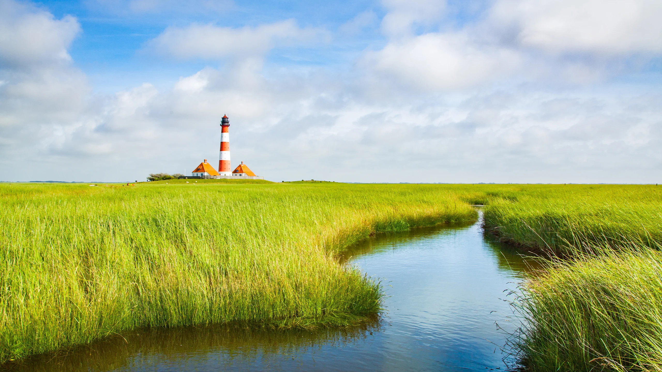
Image: Bing Daily Wallpaper | Westerheversand Lighthouse in Westerhever, Schleswig-Holstein, Germany (© bluejayphoto/Getty Images)
Open Bing today and you see brilliant green grass and a red-and-white lighthouse. It looks as though it has been placed casually on a prairie. There is no sea, no harbor, no reef and not even a proper road in sight.
But the grass is not prairie. It is salt marsh. The sea arrives twice a day, submerges part of it, then withdraws. The lighthouse can stand there only because, more than a century ago, someone first built it a hill.
An Artificial Hill
This is Westerheversand Lighthouse at the tip of the Eiderstedt Peninsula on Germany's North Sea coast. Construction began in 1906, the tower was erected in 1907, and its light first shone on May 26, 1908. It is now exactly 118 years old.
The tower consists of 608 cast-iron plates bolted together, weighing 130 metric tons in all. In German, this construction method is called Tübbingbauweise, the same principle used for segmental linings in subway tunnels. The tower is 40 meters tall. Its light sits 41 meters above mean high water and is visible for 21 nautical miles, or about 39 kilometers. Its signal is distinctive: rather than blinking on and off, the light is occulted three times every 15 seconds, as though someone quickly swept a hand across it three times. The lighthouse was automated in 1978. No keepers remain inside; it is monitored remotely from Tönning, more than 30 kilometers away.
The ground beneath it is more interesting still. The lighthouse stands not behind the sea dike but outside it, on salt marsh that disappears entirely under a storm surge. Before building the tower, workers therefore heaped up an artificial mound four meters high, compacted it repeatedly with horses, drove 127 thick oak piles into the ground as foundations, and only then erected the lighthouse.
Locally, such a mound is called a Warft. It was not invented for lighthouses. People along the North Frisian coast have lived this way for more than a thousand years, raising homes, churches and livestock sheds on mounds of their own making. Ten Hallig islands remain in the German Wadden Sea today, and they have no sea dikes at all. From November through March, as many as 20 times a year, the sea washes over an entire island until only the houses on their Warften rise above the water like small islands of their own. Locals call the event Landunter, literally "land under." Life on the island largely stops for those few hours. Residents stay indoors by the fire with something hot to drink and watch the animals and birds retreat to the mounds for refuge.
For more than a thousand years, these communities have faced one simple problem: the tide is coming, so they need a patch of high ground beneath their feet. The lighthouse is merely the most photogenic version of the answer.
The Mud Beyond the Dike Is the Real Subject
Beyond the sea dike and beneath the lighthouse lies the Wadden Sea. In UNESCO's words, this is "the largest unbroken system of intertidal sand and mud flats in the world." It stretches about 500 kilometers along the coasts of the Netherlands, Germany and Denmark, and the World Heritage property covers more than 1.14 million hectares. The site was assembled in three stages: Germany and the Netherlands in 2009, a minor boundary modification in 2011, and the addition of Denmark in 2014.
The tidal range is generally around three meters and can reach 3.5 meters during spring tides. Nearly one third of the entire Wadden Sea is exposed and submerged again in this way twice each day.
From a distance, it looks like a dreary expanse of gray mud, too barren to merit attention.
But this is the one sentence to remember: the mud is not empty. It is one of the world's busiest restaurants.
Educational material from the German national park gives the figures. On a 100-by-100-meter square of mudflat, the animals have a combined wet weight of 3 to 12 metric tons. A single square meter of mud holds millions of diatoms and thousands of small crustaceans. One species alone, the mudsnail, is only 3 to 6 millimeters long but can reach a density of 20,000 per square meter. Another national park source says "tens of thousands," rising in extreme concentrations around currents to one million; both official figures are recorded here. Then there are lugworms, the animals that leave piles of fine, noodle-shaped casts across a sandy beach. They average 20 per square meter, or about 92 billion across the Wadden Sea. Each swallows roughly 25 kilograms of sand a year, about one teaspoon per hour.
This is why mudflat walking at low tide is a recognized outdoor activity here, called Wattwandern. In Schleswig-Holstein's national park alone, about 120,000 people join licensed guides each year. The official reason for requiring a guide is specific. As the tide returns, the water can rise 10 centimeters in a few minutes. The current moves so quickly that knee-deep water can knock a person down, and swimming against it is impossible. Tidal channels slice through the flats, and the returning sea fills those channels first, quietly circling behind walkers and severing their route back. Dense fog can also arrive without warning and erase every landmark.
Ten Million Birds Come for This Meal
Now connect the two facts: a limitless table of mud and the 10 million to 12 million migratory birds that pass through each year.
That is not a figure of speech. UNESCO officially describes the property as an "essential stopover that enables the functioning of the East Atlantic and African-Eurasian migratory flyways." The German national park's own material uses the blunt verb tanken: to refuel.
Consider the dunlin, one of the Wadden Sea's most common migratory birds. It is about the size of a starling, and roughly 1.3 million visit this coast. Another official teaching resource says "more than one million"; both figures point to the same scale. A dunlin normally weighs around 50 grams, about half the weight of a chicken egg. After feeding in the Wadden Sea, it weighs 80 to 90 grams before takeoff.
In this mud, the bird increases its weight by 60% to 80%, nearly doubling it, and then flies 3,000 to 5,000 kilometers nonstop to Siberia. Teaching material for children published by the German national park and the World Wide Fund for Nature connects that departure weight directly to what follows:
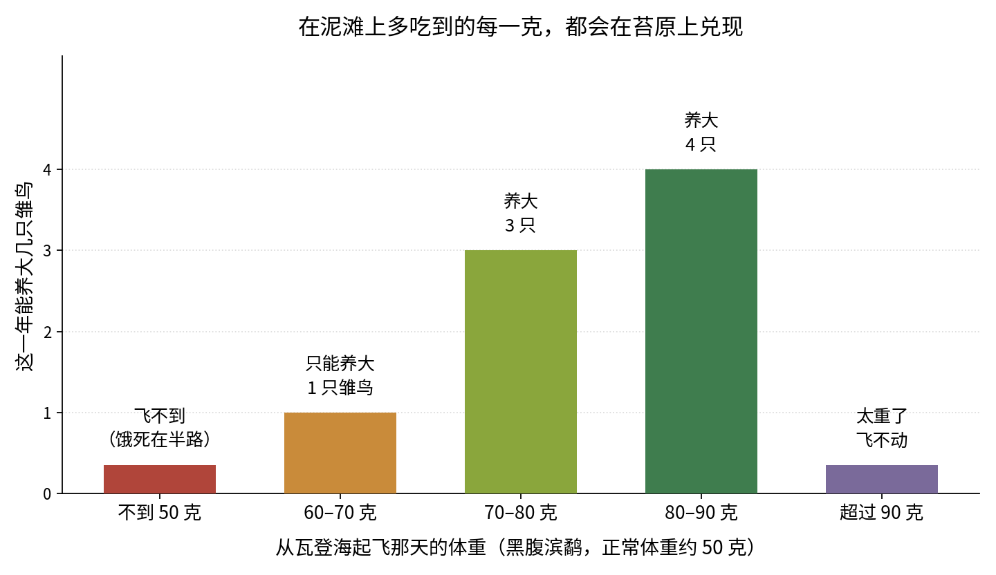
Above: A dunlin's weight when it leaves the Wadden Sea and the number of chicks it can raise that year. Data from teaching materials produced by Germany's Wadden Sea National Park and the World Wide Fund for Nature.
Whether it raises one chick or four depends on the few extra grams shown on the scale at departure.
One square meter of mud -> one bird's weight -> the number of young standing on the tundra next year. The chain has only three links, and every one is concrete.
A Town Is Buried Beneath the Mud
One more fact makes these flats worth a closer look.
In January 1362, a storm surge later known as the Grote Mandrenke, or "Great Drowning," swept across the southern North Sea coast. At least 25,000 people died; some estimates run as high as 100,000. Forty-four villages were destroyed in a single event. The prosperous town said to have vanished was Rungholt. For centuries, it survived only in legend and poetry - until recently.
In May 2023, Schleswig-Holstein's state archaeology department announced that surveys beneath mudflats near the Hallig of Südfall, not far from the lighthouse, had detected the foundations of a 40-by-15-meter church and a two-kilometer chain of medieval Warften. By 2024, another 19 Warften had been found, linking the port and church districts. Across the area, researchers have now identified 54 Warften, a complete drainage system and a sea dike with a harbor. The archaeologists' conclusion is plain: today's mudflat was once densely settled land on a large scale.
That is the full story of this mud: the tide swallowed a town, then turned it into a dining hall for 10 million birds.
China's Answer to the Same Problem
Now turn the globe 8,000 kilometers.
Along the coasts of the Yellow Sea and Bohai Gulf lies a World Heritage property called the Migratory Bird Sanctuaries along the Coast of Yellow Sea-Bohai Gulf of China. Its inscription differs from the Wadden Sea's. The Wadden Sea qualifies under three criteria; the Chinese property qualifies under only one: criterion (x), biodiversity. It was listed entirely for its birds. UNESCO describes the Yellow Sea and Bohai Gulf as a bottleneck for millions of migratory waterbirds. The area carries more than 10% of all migration along the East Asian-Australasian Flyway, and at least 45 threatened bird species depend upon it.
The property has grown in stages. It began with two sites in Yancheng, Jiangsu, in 2019. In 2024 it expanded to include Chongming Dongtan in Shanghai; the Yellow River Delta in Dongying, Shandong; Nandagang in Cangzhou, Hebei; Snake Island-Laotieshan in Dalian, Liaoning; and the Yalu River estuary in Dandong. In July 2026, the Changshan Islands in Dalian, Liaoning, were added, contributing more than 4,900 hectares. The property now comprises eight component areas across Jiangsu, Shanghai, Shandong, Hebei and Liaoning.
The two flyways are in very different condition.
On the East Atlantic Flyway that includes the Wadden Sea, most of 81 populations are stable or increasing. Arctic-breeding long-distance waders are still declining: the common eider lost 118,000 birds over 27 years, a drop of 39%, while the Eurasian oystercatcher lost 159,000, a decline of 28%. On the Yellow Sea side, a paper in Nature Communications offers an almost laboratory-like comparison: shorebirds highly dependent on the Yellow Sea are declining by 5.2% each year, with the worst-affected losing 8% annually; groups that rely on the Yellow Sea for no more than 40% of their needs decline by only 1.0% a year. The birds share the same sky. The difference is where they refuel.
The reason is equally visible. The Yellow Sea's tidal flats have shrunk by more than 65% in recent decades. Nearly 30% disappeared to coastal development over the past 30 years, and the flats continue to decline by more than 1% each year.
720 Mu and Four Meters
The neatest echo appears at Tiaozini in Yancheng, Jiangsu.
In 2019, staff there identified a problem: during the highest tides, the waterbirds had nowhere to land. Beyond Tiaozini lies the world's largest radial sand-ridge system, whose flats are extraordinarily rich in bottom-dwelling life and serve as a natural dining hall for birds. But at high tide, the entire flat disappears beneath the water and the birds have nowhere to stand.
Local authorities therefore leased 720 mu of fish ponds and restored them to wetland, creating China's first high-tide roost built specifically for migratory birds. In plain terms, they kept a patch of dry ground under the birds' feet during the few hours when the tide reaches its highest point.
It is the same answer to the same problem that North Frisians solved with Warften a thousand years ago and with the four-meter mound beneath the lighthouse: when the tide comes, something must be raised above it. One patch was made for people; the other for birds.
The results are measurable. The latest formal global estimate for the spoon-billed sandpiper is about 443 mature individuals, and the population is still declining by about 5% a year. The 2014 estimate was 661 to 718. The world's first comprehensive scan survey of spoon-billed sandpipers was conducted along the Jiangsu coast. At Tiaozini, the highest count in a single survey is 224 spoon-billed sandpipers - meaning that nearly half the world's population has stood on these 720 mu at the same time. The number of Nordmann's greenshanks also rose from fewer than 1,000 to nearly 2,000.
September's Autumn Migration Peak
September is when this chain is busiest.
A survey published by the Dongtai municipal government during the peak autumn migration counted 188,500 waterbirds of 32 species, 90% of them shorebirds. More than 300,000 waterbirds were recorded across the wider area. The birds remain at Tiaozini for two to three months, completing their molt before continuing south.
The lighthouse is beautiful, but it is really only a marker. What deserves a longer look is the mud beneath it, dismissed for centuries and now measured: 20,000 snails in one square meter; one small bird eating its way from 50 grams to 90; and, as a result, three more chicks standing on the tundra the following year.
Sources: UNESCO World Heritage List entries 1314 and 1606; Germany's Wadden Sea National Park; Schutzstation Wattenmeer; Germany's Federal Waterways and Shipping Administration (WSA Elbe-Nordsee); the Wadden Sea Quality Status Report; the World Wide Fund for Nature's Pause im Wattenmeer; the State Archaeology Department of Schleswig-Holstein; Nature Communications on Yellow Sea tidal flats and shorebird population trends; Wader Study on the global spoon-billed sandpiper population estimate; China's National Forestry and Grassland Administration; People's Daily; Xinhua Daily; Dongtai Municipal People's Government; Shanghai Municipal People's Government.