
A still lake filled with reflections. Yet water normally returns only 2% of the light striking it head-on. How does it become a mirror?
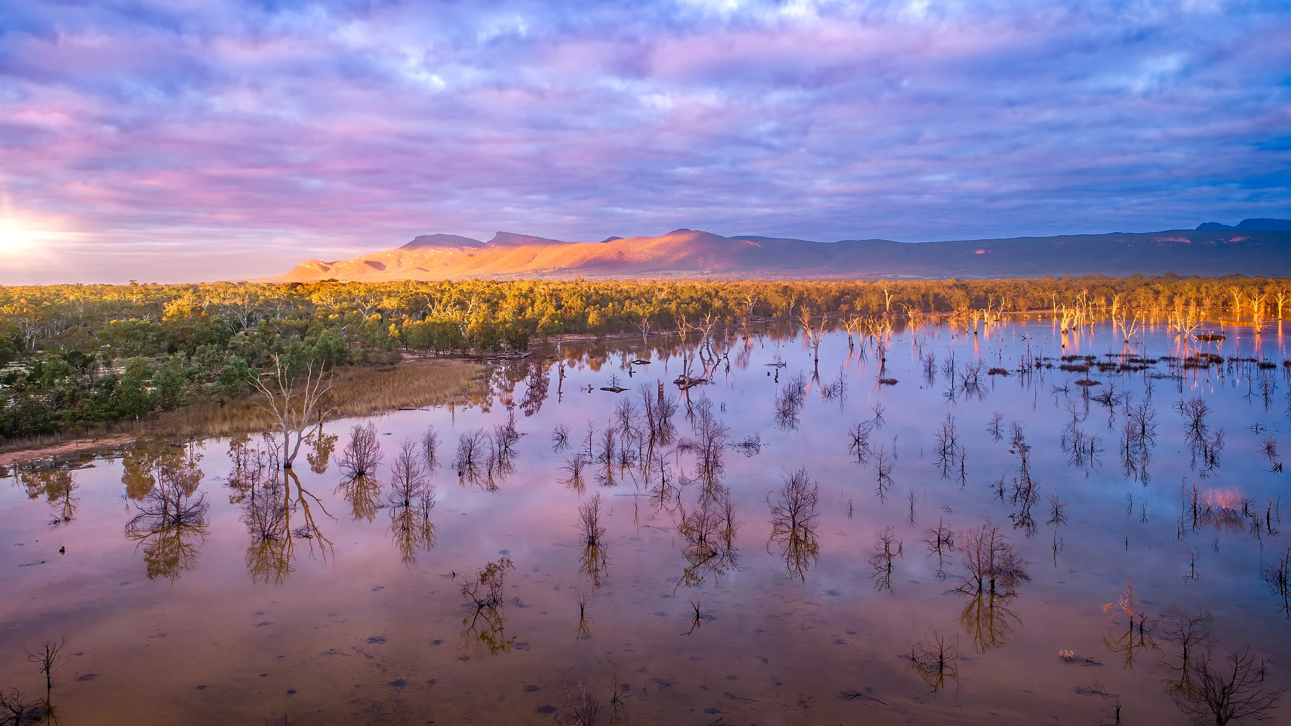
Image: Bing Daily Wallpaper | Lake Fyans, Grampians National Park, Victoria, Australia (© tracielouise/Getty Images) | Official image

Bing's Chinese title for today's image is admirably direct: A Reservoir Filled With Reflections. Six Chinese characters contain the whole scene - a body of water holding everything on its shore.
There is no need to describe the composition. The interesting question fits in a single sentence: what gives water the right to behave like a mirror?
The answer is more interesting than "because the surface is flat." In truth, water is a very poor mirror. Viewed straight on, it returns only 2% of the light. Today's lake-wide reflection depends on two things the photograph cannot show: the wind stopped that morning, and the photographer got low.
A Lake, and the Year 1916
First, one detail Bing does not get quite right.
Its caption places Lake Fyans in Grampians National Park, but the lake is outside the park boundary. Fisheries Victoria says it is "located at the foot of the Grampians National Park between the townships of Stawell and Halls Gap." GWMWater, which manages it, says the lake's land belongs to GWMWater, not the national park.
Another word in the caption, however - "reservoir" - is entirely correct, and more honest than "lake."
According to GWMWater's official Lake Fyans Management Plan, this body of water was created in 1916 by building an earth embankment. At its maximum operating capacity of about 18,500 megalitres, it covers roughly 493 hectares and has a maximum depth of only about 6.2 metres. Its own catchment is small; most water arrives by channel from Stoney Creek or Lake Bellfield, at up to 200 megalitres a day. Its first purpose is not scenery but supplying Stawell, Ararat, Great Western and nearby farms.
The number to remember is 6.2 metres. A sheet of water scarcely six metres deep and nearly 500 hectares wide can readily raise waves when the wind arrives. It is not naturally quiet like a well. Becoming a mirror takes conditions.
The reservoir is also one of the area's most important recreation lakes. A roughly 9.6-kilometre trail circles the shoreline, and Fisheries Victoria describes the lake as renowned for "large brown trout, feisty rainbow trout and abundant redfin."
Water Naturally Reflects Only 2% of Light
Now for the mirror.
When light reaches water, it splits: some bounces back as reflection, while some enters as refraction. The proportions depend on the angle at which you see the surface. This is the Fresnel effect.
The standard reference Ocean Optics Web Book gives the beginning of the curve. When light strikes water perpendicularly, its reflectance is
R = ((n-1)/(n+1))^2
Water's refractive index in visible light is about 1.34. Substitution gives 0.021, or 2.1%.
Look straight down into a pond and the "mirror" beneath you returns only 2% of the light; nearly 98% enters the water. That is why you see stones and leaves on the bottom rather than the sky. Every child who has played beside water has tested Fresnel reflection without knowing its name.
The same book supplies the other half of the story:
As the angle approaches grazing incidence, reflectance approaches 100%.
At grazing incidence, your line of sight lies almost along the water. Only then does the surface become a convincing mirror and return nearly all the light.
So the familiar photographic advice to crouch for a reflection is not merely aesthetic. It is a precise instruction from physics. Photograph the same puddle while standing and you get concrete; lower the phone to within centimetres of the surface and you get an entire building. The water has not changed. Your position on the Fresnel curve has.
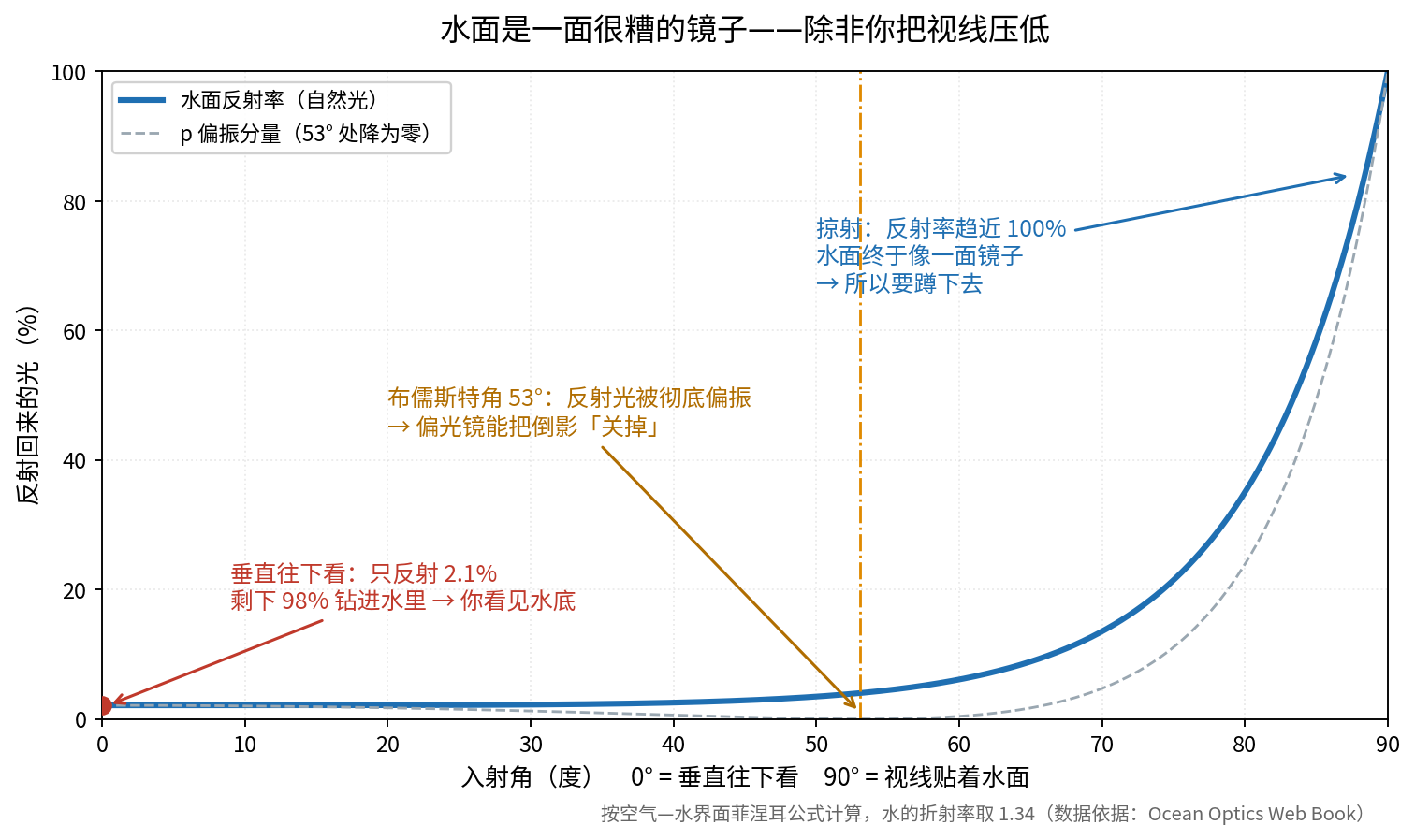
One often-misrepresented angle also deserves attention. Water has a special Brewster's angle, arctan(1.33), or about 53 degrees. At that angle reflected light becomes completely polarized. It is not the angle of maximum reflection; reflections are brightest toward grazing incidence. Fifty-three degrees is useful for the opposite reason: turn a pair of polarized sunglasses by ninety degrees and you can almost switch the reflection off, looking directly into the water. That one property explains why anglers and landscape photographers buy polarizing lenses.
One Knot of Wind Separates a Mirror From Shattered Glass
Reflectance explains why the photographer must crouch. It does not yet explain why that particular morning worked.
The answer appears in a nineteenth-century table. Force 0 on the Beaufort scale means wind below 1 knot, with 1 knot equal to about 0.5 metre per second. Its sea-state description is exact:
Sea like a mirror.
At Force 1, just 1 to 3 knots, the description immediately becomes "ripples with the appearance of scales, without foam crests."
That tiny breath of wind - slower than a walking pace - is all that separates a mirror from shattered glass.
The small wrinkles raised by wind are called capillary waves. According to Roger Williams University's open oceanography text, their wavelengths are less than 1.7 centimetres; beyond 1.7 centimetres they become wind waves. A layer of ripples scarcely more than a centimetre long can destroy the reflection of an entire lake.
The U.S. National Oceanic and Atmospheric Administration puts it neatly. A perfectly smooth surface produces just one glint. Once even the lightest wind ripples it, the reflected image wrinkles and blurs because the light source is reflected from multiple points at once. NOAA also gives a measurable relationship: the angular width of a glitter path is four times the water's maximum slope angle. The width of that trembling band of light therefore tells you how uneven the surface is.
Why does wind often stop around dawn? Penn State's atmospheric-boundary-layer course gives a clean chain of cause and effect. After sunset, the ground loses heat through infrared radiation, cooling the air beside it and making it thermally stable. Surface friction still creates turbulence, but the atmosphere's stability suppresses vertical mixing; as the ground continues to cool, the boundary layer grows more stable through the night. Stable air resists overturning, so winds aloft do not reach the ground. Soon after sunrise, solar heating restarts convection and mixing, and the wind returns.
The useful window is therefore around sunrise through roughly the following hour, and again after the evening atmosphere stabilizes. Reflection photographers go out at these times believing they are chasing light. They are also chasing the interval without wind.
A Reflection Is Not a Flipped Photograph
There is one more thing nearly everyone imagines incorrectly.
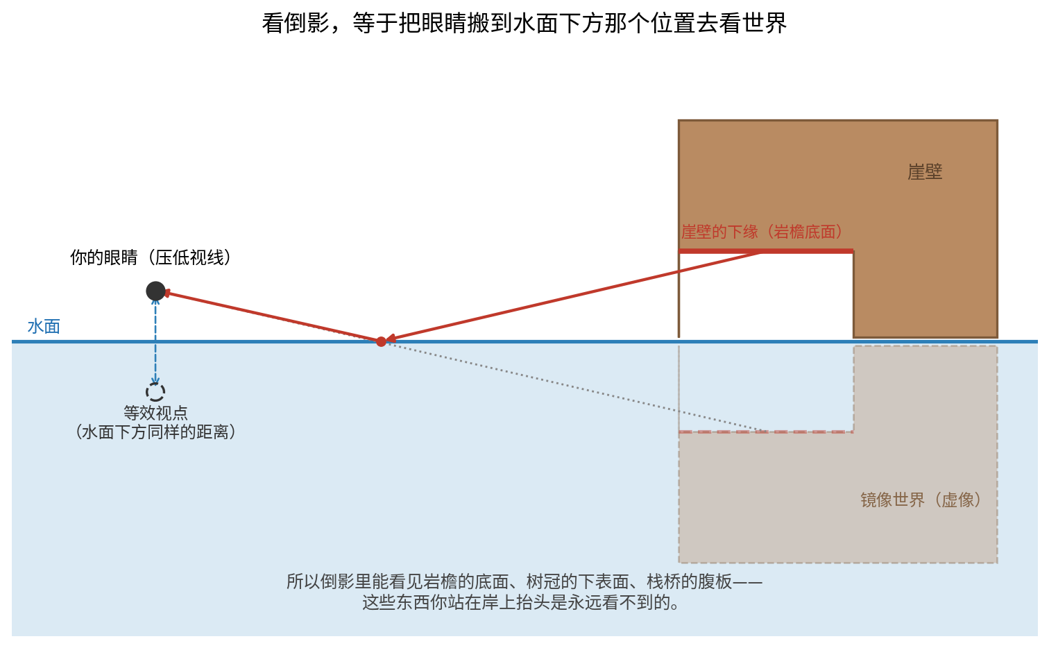
A reflection is not the upper half of a picture copied and turned upside down. OpenStax's University Physics, Volume 3 explains that a plane mirror forms a virtual image: reflected rays extended behind the mirror appear to originate from a point there; the object's distance in front equals the image's distance behind; and the image cannot be projected onto a screen because the rays only appear to come from that common point.
Apply that geometry to a lake and the result is illuminating: to see the reflection is effectively to move your eyes to their mirrored position below the water and look out at the real world from there.
The viewpoint changes, so the visible surfaces change. A reflection may reveal the underside of a cliff, the bottoms of tree crowns or the belly of a pier - surfaces you cannot see by looking up from the shore. Conversely, from the bank you cannot see in the reflection anything hidden behind the summit.
A reflection is not a duplicate. It is a view upward from below the water. The next time you see a reflection photograph, look for an underside. Once you find it, you have really understood the mirror.
The Escarpment Beyond the Frame, and 2,000 Symbols
With the mirror understood, consider what it contains.
The mountains behind Lake Fyans have two names. Grampians came from a Scottish range. Their older name is Gariwerd. Victoria's First Peoples-State Relations office says this has been the home, hunting ground, gathering place, farm, ceremonial site and "dreaming place" of the Jadawadjali and Djab Wurrung peoples for more than 22,000 years.
The rock matters too. VicFlora, the Royal Botanic Gardens Victoria's official flora, says the Grampians' distinctive landscape resulted as Upper Silurian to Lower Devonian quartz-rich sandstone was folded, faulted and eroded. Its roughly parallel ridges characteristically present steep scarps to the east and gentle dips to the west.
That sentence describes a classic landform: a cuesta. One side is a cliff; the other follows the tilted rock beds down a mild slope. The sand began as quartz carried by rivers. English Wikipedia gives a total accumulated thickness of 7 kilometres before the layers were uplifted and tilted into their present form. The highest point is Duwul, or Mount William, at about 1,167 metres.
Sandstone also helped preserve the range's most precious records: rock art.
Parks Victoria says that about 140 recorded rock-art sites lie within Grampians National Park, five open to the public. They account for 90% of Victoria's known rock-art sites, and some are more than 20,000 years old. Most occupy rock shelters, which provide both protection and a broad view.
The most remarkable single site is Billimina. The Victorian government calls it the state's richest single rock-art site, with more than 2,000 motifs.
Two thousand symbols beneath one sandstone overhang, looking out over the valley for a very long time.
A Fire Burned Nearly Four-Fifths of the Park
One fact about Billimina must be stated: it is closed today.
Dry lightning ignited several fires in the park's south on December 17, 2024. Forest Fire Management Victoria reported that by the time the fire was contained on January 7, 2025, it had burned more than 76,000 hectares of national park and farmland across a 422-kilometre perimeter. It destroyed four homes and 40 outbuildings around Moyston and Mafeking, as well as 775 sheep, one horse, one beef cow and 1,285 beehives.
But 76,000 hectares covered only the first fire. A second began on January 27, 2025. Parks Victoria's recovery page gives the final total:
The two fires burned 135,000 hectares - nearly 80% of the park.
The park covers 167,219 hectares. The arithmetic really does approach four-fifths.
Affected species included the critically endangered brush-tailed rock-wallaby and endemic plants found nowhere else on Earth. The Victorian government committed A$1.88 million to an initial round of biodiversity and habitat recovery, including control of introduced predators and temporary shelters for animals that had lost cover.
By 2026, much of the park had returned. The Mount Rosea Walk, Borough Huts Campground, Tunnel Walk and sections of the Grampians Peaks Trail had reopened, along with most roads. Yet the official page still lists closures, including this one:
Billimina Track and Rock Art Shelter remain closed to visitors.
An overhang bearing 2,000 symbols and looking over the valley for 20,000 years is temporarily invisible to people because lightning began a fire. This is not sentimentality. It gives the abstraction of climate and wildfire a scale small enough to remember.
(Fortress Track and Campground, Chimney Pots Walk and Red Gum Walk are also closed. Current official notices should be checked before any visit.)
One-Third, and the Wildflowers of Early September
One number turns the story back toward recovery.
Parks Victoria's Grampians National Park (Gariwerd) Flora Guide lists nearly 970 native plant species, about 49 endemic to the area and found nowhere else in the world. Most strikingly, the park protects about one-third of Victoria's plant species.
Victoria covers 227,000 square kilometres. Grampians National Park covers just 1,672 - less than 1% of the state - yet protects one-third of its plant diversity.
(Two official pages disagree. The flora guide says the region has more than 1,300 plant species, including 130 orchids and 49 endemics; a Parks Victoria news page says more than 1,130 species, 130 orchids and more than 40 endemics. Both are official, so the fair range for endemic species is about 40 to 50.)
Why did Bing publish this photograph on September 6?
It marks no anniversary; the caption link points only to a general search for Grampians National Park. But the season is exact. Spring begins in the Southern Hemisphere on September 1, and Parks Victoria says the best wildflower viewing runs from early September through October.
The week this image reached the homepage was therefore among the first days when a park burned across nearly four-fifths of its area was flowering again. A recently burned landscape, one-third of a state's botanical diversity and early September make a better reason than an anniversary.
(The credited photographer, tracielouise, supplies Getty Images and iStock. No public biography, nationality or interview could be found - common for stock photographers whose work may be seen by hundreds of millions while the credit remains a lowercase name.)
China Has a Mirror Made by Another Route
China has a mirror formed by a different mechanism: Chaka Salt Lake in Qinghai.
According to a July 2022 report in the overseas edition of People's Daily, Chaka covers 105 square kilometres at an average elevation of 3,059 metres. Its crucial feature is that the water is shallow enough to reach only the ankles; beneath the clear brine lies a well-mineralized salt bed several metres thick. The lake therefore reflects strongly, like a mirror.
Lake Fyans is more than six metres deep. It becomes a mirror when the wind stops. Deep water lets wind build waves, so the lake must wait for the stillness of morning.
Chaka relies on being shallow. Ankle-deep water cannot develop substantial waves - gravity waves need depth, and centimetres of water cannot support centimetre-scale waves. The flat white salt bed below is itself highly reflective. Chaka can remain a mirror under a high sun.
Windless deep water and extremely shallow brine are two routes to the same mirror. One depends on weather; the other, on geology.
Sources: GWMWater's Lake Fyans Management Plan and reservoir page; Fisheries Victoria's Grampians fishing page; Parks Victoria's pages on Grampians National Park, Aboriginal heritage, fire recovery and wildflowers, and its Grampians National Park Flora Guide; Victoria's First Peoples-State Relations page on Gariwerd; Forest Fire Management Victoria's media release; Royal Botanic Gardens Victoria's VicFlora entry on the Grampians; Ocean Optics Web Book, "The Level Sea Surface"; NOAA Physical Sciences Laboratory, "Glittering Light on Water"; OpenStax, University Physics Vol. 3; Penn State METEO 300 course notes; Roger Williams University, Introduction to Oceanography; the Beaufort scale; and the July 11, 2022 overseas edition of People's Daily, "Chaka Salt Lake: Lake Water Melts Into the Blue Sky."