
A wave photographed from above, and a secret the shore can never reveal.
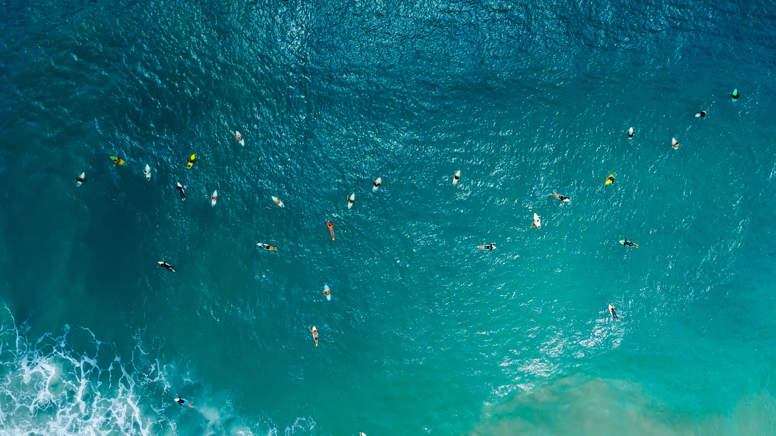
Image: Bing Daily Wallpaper | Aerial view of surfers, Santa Catarina, Brazil (© Wonderful Nature/Shutterstock) | View on the Bing homepage
Open Bing today and the screen fills with ocean seen from above. A wave advances from deep in the frame, white water spreading along a curve, while several tiny figures ride across it. Bing calls the wallpaper Reading the Message Between the Waves.
There is a neat connection to yesterday's image of Mont-Saint-Michel at high tide. Two days, two kinds of moving water. But they are different phenomena, and separating them is the first step toward reading today's photograph.
First Ask What Is Doing the Pushing
We often talk about tides and waves as though they were the same thing. They are not.
The US National Oceanic and Atmospheric Administration gives tides an interesting definition: they are extremely long-period waves that move through the oceans, driven by the gravitational pull of the Moon and Sun. Wind waves, the same agency says, are generated by friction between wind and surface water.
So the precise distinction is not that a tide is not a wave. Both are waves; what differs is the force driving them and their scale. A tide is an immensely long wave pulled by the Moon and Sun, with a cycle lasting more than 12 hours. A wind wave is rubbed into being by the wind, with a cycle of only a few seconds.
Everything in today's photograph is the work of wind.
Where Did That Wave Come From?
Here is a fact that may be surprising: these waves did not drift north from some distant Antarctic storm.
A 2026 study is clear that the chief drivers of high-energy waves on Brazil's southern coast are extratropical cyclones, storm systems that form over the South Atlantic and then travel east. Another study describes the ordinary wave climate here: an average significant wave height of 1.76 meters, an average period of 8.07 seconds, and a prevailing wave direction from 126 degrees southeast. The researchers also recorded a rhythm of roughly six cold-front systems reaching South America each month.
The chain of cause and effect is short: a storm forms not far offshore, wind rubs across the surface, energy travels onward, and a few days later it reaches a beach in Santa Catarina.
Wind needs three things at once to build large waves. NOAA's educational material lists wind speed, duration, and fetch - the length of water across which the wind blows in one direction. One qualification is especially worth remembering: if the wind is too slow, the waves will not grow large no matter how long it blows or how broad the fetch. All three conditions must be present.
The Counterintuitive Part
From shore, a wave looks like a wall of water marching toward land.
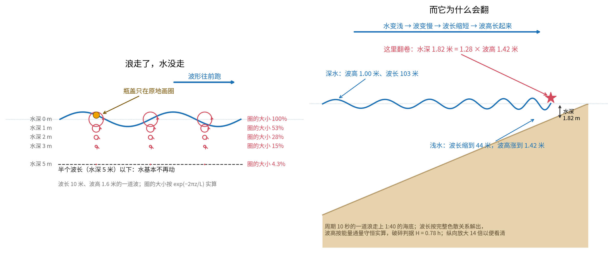
But NOAA puts it this way: "Waves transmit energy, not water." The same page is blunter still: water does not actually travel with a wave.
What does it do instead? It traces circles in place. As energy passes through the water, each water particle begins an orbital motion - up, forward, down and back, returning to almost where it began. The wave has moved dozens of meters; the molecule has merely completed a loop.
A marine meteorology course at the University of British Columbia offers a particularly clear image: a gull on the sea rises and falls with a wave, but the gull does not move along with it. It is lifted and lowered in place.
Those circles have another revealing property. The University of Hawaii's ocean-science course states that below a depth of half the wavelength, water is essentially no longer affected by the wave. How deep a wave reaches beneath the surface therefore depends on how long it is.
A Number That Can Be Calculated
In deep water, a wave's speed depends only on its period. Coastal engineers use a strikingly simple approximation: phase speed in meters per second is about 1.56 times the period in seconds.
For a long-period swell with a 14-second period:
Its shape advances at 21.8 meters per second, or about 79 kilometers per hour - highway speed. Its wavelength is 306 meters, almost three regulation soccer fields placed end to end. Its effective depth is 153 meters: water more than 150 meters below the surface is still tracing small circles for this wave.
But that is not the speed that determines when the swell reaches shore. In deep water, a group of waves travels at only half the phase speed, about 39 kilometers per hour - faster than a bicycle, slower than a car.
This also explains a rule surfers use every day. The US Army Corps of Engineers' Coastal Engineering Manual says that when several wave trains coexist, longer-period waves travel faster. The Scripps Institution of Oceanography states it more directly: long-period waves arrive first. After a storm, the first waves to reach a distant coast are therefore the longest and fastest - and precisely the waves surfers want most.
Why Waves Break
A wave can cross thousands of kilometers of deep ocean with almost no change in shape. The transformation happens in the final few dozen meters.
As the water grows shallower, the wave slows. The waves behind catch those ahead, crowding together as their wavelength shortens and their height rises. As the University of Hawaii course explains, when waves slow they bunch up and grow taller.
Then they break.
Where? An approximation more than a century old supplies an answer. In 1891, John McCowan calculated that a wave breaks when its height reaches about 0.78 times the water depth. Inverted into a more memorable form, a one-meter wave begins to break in water roughly 1.28 meters deep.
But 0.78 is not an iron law, and that caveat matters more than the number. Delft University of Technology teaching material notes that the ratio changes with the slope of the seabed: about 0.6 to 0.8 for spilling breakers and 0.8 to 1.2 for plunging breakers. The European Union's Coastal Wiki reports an observed difference of about 20 percent, with the breaker index higher for plunging than spilling waves.
The same "law" yields different numbers over different seabeds. That is not scientific sloppiness. It is science taking the real world seriously.
The bottom slope shapes not only the number but the character of the wave. Over a gentle slope, the crest crumbles gradually into white water, producing a spilling breaker. Over a moderately steep bottom, the crest curls forward and crashes into its own base, creating the hollow plunging breaker familiar from photographs and films. Over an even steeper bottom, the crest may not break at all; the wall of water surges directly onto the beach as a surging breaker.
The reason some waves can be surfed and others cannot lies not in the water, but in the arrangement of sand beneath it.
Engineers classify these breakers with a parameter called the Iribarren number. Yet the US Army Corps of Engineers, the EU's Coastal Wiki, and Delft teaching material give three slightly different numerical boundaries. Their definitions differ: deep-water or local quantities, regular or irregular waves. A number never stands alone; its definition travels with it.
What Exactly Is a Surfer Riding?
A 2017 paper in the Journal of Fluid Mechanics gave surfing a physical criterion: for an object to remain accelerated by a wave, it must travel near the wave's phase speed and stay within a narrow region on the forward face of the crest.
In plain language, a surfer is not simply pushed along by a wave. The surfer stands on a moving slope made of water and slides down it under gravity. To remain on that slope, the rider must descend as quickly as the slope advances - like walking down an escalator that is forever moving upward.
Seen this way, the photograph changes. Those tiny figures are not being shoved by the sea. They are using gravity to chase a fast-moving hill.
The Coast and the People It Shaped
The photograph was taken in Santa Catarina, Brazil's smallest southern state, with an area of roughly 95,400 square kilometers. A study in the volume Brazilian Beach Systems gives the scale of its coast: 922 kilometers including bays, with 246 sandy beaches accounting for 60 percent of the shoreline.
Along that coast lies Guarda do Embaú, Brazil's only World Surfing Reserve.
Two dates correctly describe that status: it was approved in December 2016 and formally dedicated in October 2019 as the ninth reserve worldwide. South America's first was Huanchaco, Peru, in 2013; the second was Punta de Lobos, Chile, in 2017.
The reserve protects more than waves. Its official page lists three assets: the Madre River, a complete estuary system, and a mature dune system. It protects three breaks, borders the state's largest nature reserve, and overlaps an environmental protection area for southern right whales.
It also prompted Brazil's first serious attempt to calculate what a wave is worth. In 2018, the conservation organization and a research group at the Federal University of Santa Catarina conducted a full year of research, interviewing 368 surf tourists and 20 local hotel operators. They found that surfing generated $4.2 million in annual spending. Surfers made up only 44 percent of visitors but contributed about 77 percent of tourism's local economic impact - on average, a surfer spent twice as much as another visitor.
A wave, it turns out, can appear on a balance sheet.
This coast also produced a champion. The 2025 world surfing champion, Yago Dora, was born in Florianópolis, Santa Catarina. The Brazilian Olympic Committee describes his birthplace that way, and the World Surf League athlete profile lists the same city as his hometown.
In other words, the sea in today's wallpaper has just produced a reigning world champion.
The Chinese Girl
Surfing formally joined the Olympic program in 2016 and made its Games debut in Tokyo in 2021. China's General Administration of Sport has described the country's starting point candidly: surfing was relatively underdeveloped, and before its Olympic inclusion China held only one competition a year and had a small base of participants.
China formed a national surfing training squad in 2018. Six years later, on March 1, 2024, a 15-year-old girl from Sichuan named Yang Siqi completed four main rounds and one repechage round in Puerto Rico to qualify for Paris - the first Chinese surfer ever to qualify for an Olympic Games.
At the Paris Games, with the actual competition held in Tahiti in the South Pacific, the official Chinese report says she faced extremely challenging swells without fear, advanced through two rounds to the final 16, then lost in the third round to American Caroline Marks and finished tied for ninth.
Marks won the gold medal. Brazil's Tatiana Weston-Webb took silver.
China's first Olympic surfer competed beside an athlete from the country shown in today's wallpaper.
China currently has one location documented by a primary official source for formal training: Riyue Bay in Wanning, Hainan. A national surfing team training base was established there in 2017, and in June 2020 it received the designation "National Sports Training Southern Base - Hainan Wanning Surfing." National and provincial teams train there year-round.
What the Aerial View Reveals
Now return to the photograph itself. It was taken from the air.
From above, the entire shape of a wave and the tracks of the surfers become visible. So does something that cannot be seen nearly as clearly from shore - and that kills about 100 people each year in the United States.
It is a rip current.
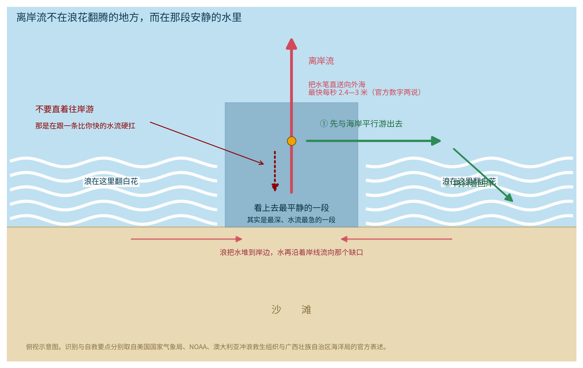
The US National Weather Service explains how one forms. Where waves break unevenly along a shore, stronger breakers pile water higher. That water runs toward a lower area, collects at a weak point in the line of breaking waves, and funnels seaward.
How fast can it move? The National Weather Service gives a typical speed of 0.3 to 0.6 meters per second and a maximum of 2.4. The Oceanic Administration of China's Guangxi Zhuang Autonomous Region gives 0.3 to 1 meter per second and a maximum of 3. The official figures differ, but the conclusion is the same: a rip current can move much faster than an ordinary person can sustain in the water. NOAA says directly that one can outrun an Olympic swimmer.
From shore, Guangxi's guidance describes the signs clearly: a calm gap interrupting a band of white breakers parallel to the shore, or an area where foam or sediment can be seen moving seaward. Surf Life Saving Australia lists five features: deeper or darker water, fewer breaking waves, sandy-colored water extending beyond the surf zone, floating debris or seaweed, and visibly moving water.
The counterintuitive point is crucial: the dangerous channel is not where the surf churns, but the stretch that looks calmest. People enter because it appears easiest to swim.
Official advice comes in two forms, and both matter. NOAA says not to fight the current, but to swim parallel to the shore and then angle back toward land. Surf Life Saving Australia's three steps are to relax and float to conserve energy, raise an arm to attract attention, and wait for rescue. Official Chinese-language guidance from the New South Wales government adds: float with the current, because some rips circulate back toward shallower water.
These instructions are not contradictory. The American advice emphasizes leaving the channel; the Australian advice emphasizes that panic and exhaustion are the real killers, and that a meaningful share of rips recirculate toward shallow water. They share one premise: do not swim directly against the current toward shore.
Guangxi's two prohibitions are equally direct: do not immediately struggle shoreward, and do not attempt an unauthorized heroic rescue.
The cost is real. Official National Weather Service statistics show that between January 1 and August 19, 2026, 47 people died in US surf zones, 34 of them in rip currents. A peer-reviewed 2019 study produced an even more striking figure: at beaches with breaking waves, rip currents caused 81.9 percent of rescues.
Sources: NOAA's National Ocean Service and the US National Weather Service on waves and rip currents; the University of Hawaii at Manoa's Exploring Our Fluid Earth; the US Army Corps of Engineers' Coastal Engineering Manual; Delft University of Technology's Coastal Dynamics; Coastal Wiki; Pizzo, "Surfing surface gravity waves" (Journal of Fluid Mechanics, 2017); Brewster et al., "Estimations of rip current rescues and drowning in the United States" (NHESS, 2019); Miranda et al. (Meteorology, 2026) and the southern Brazilian wave-climate study in Energies 8(12); Klein et al., Brazilian Beach Systems; Save The Waves Coalition and the official Reservas de Surf page; the Brazilian Institute of Geography and Statistics; athlete profiles from the Brazilian Olympic Committee and World Surf League; the International Surfing Association; China's General Administration of Sport; the Oceanic Administration of the Guangxi Zhuang Autonomous Region; Surf Life Saving Australia and the New South Wales government's official Chinese-language guidance; and China's National Meteorological Center.