
Near Ankola, Karnataka, India: a beach named for a fishing community, on a coast whose climate was rewritten by a mountain range.
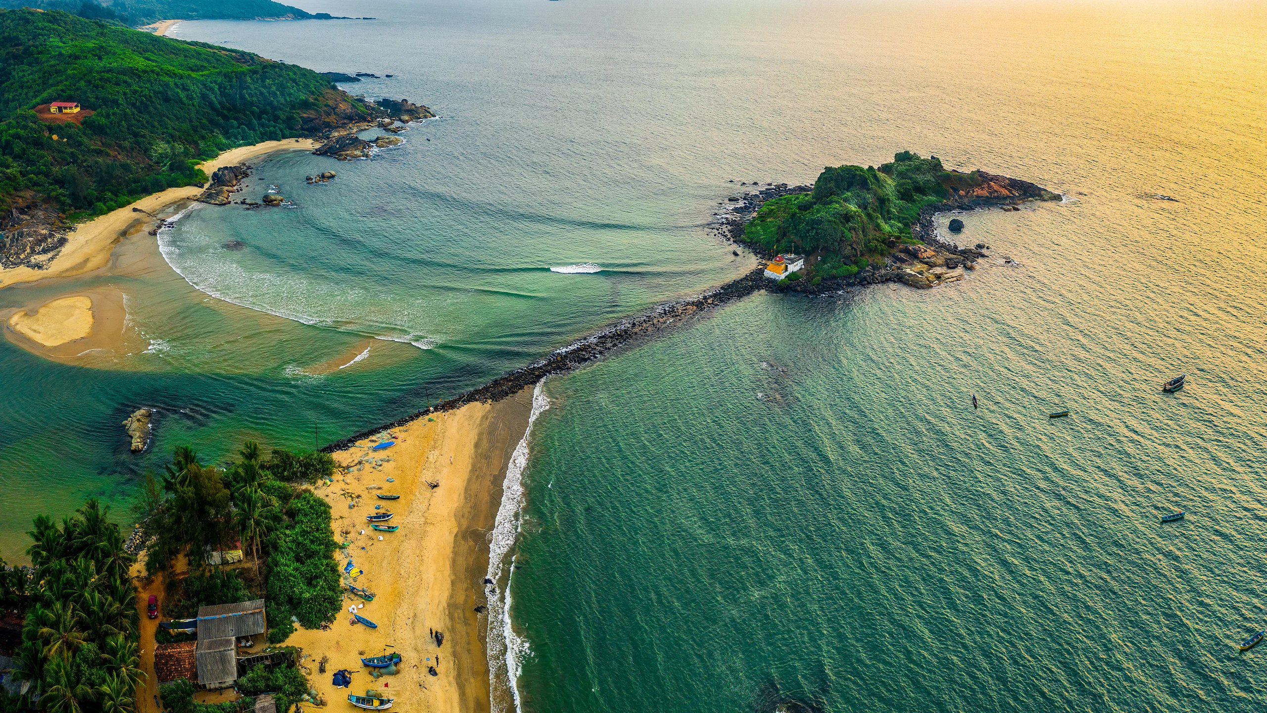
Image: Bing Daily Wallpaper | Gabit Keni Beach near Ankola, Karnataka, India (© Amith Nag Photography/Getty Images)
Open Bing today and the homepage is all sea. Its title is simply "Life on India's West Coast."
The location is precise: Gabit Keni Beach, near Ankola in the Indian state of Karnataka. This is the Arabian Sea side of India's west coast, south of Mumbai, past Goa, then another two hours by road. Locally, it is part of the Konkan coast. Ankola itself is small, with a population just over 20,000 in 2011. A national highway runs through town; the district capital, Karwar, is 33 kilometers away.
Curiously, Bing has attached no observance to today's image. Its copyright link contains only a search term: Ankola, Karnataka, India. In other words, the picture has no occasion. It is simply beautiful. But behind this beach are three stories, each more interesting than an anniversary.
A Wall That Splits the Rain in Two
India's west coast has a feature that few other places can reproduce: a wall rises behind it.
That wall is the Western Ghats, known locally as the Sahyadri. The range runs north from India's southwestern tip for nearly 1,600 kilometers, almost hugging the coast. UNESCO's World Heritage description offers two details worth remembering: the range is "older than the Himalayan mountains," and it "influences the Indian monsoon weather patterns," presenting one of the best examples of a tropical monsoon system on Earth.
The wall works like this. Each June, winds cross the Indian Ocean laden with moisture and strike the mountains. There is nowhere to go but up. Rising air cools, and cooling air releases its water.
That may sound like a geography textbook, but its consequences can be measured. An official Central Ground Water Board handbook for Uttara Kannada district, where Ankola lies, lists the normal annual rainfall for each taluk. Within one district, coastal Bhatkal receives 4,145.6 millimeters; Mundgod, beyond the mountains inland, receives only 1,176.8 millimeters.
More than four meters of rain on one side, 1.2 meters on the other. The wall stands between them.
The Soil Here Is the Color of Rust
Stand on this coast and another feature becomes obvious: the soil is red. Not reddish, but brick red and rust red.
This is laterite, the classic product of tropical weathering. An official Geological Survey of India report puts it plainly: most of Karnataka's rock sequences have undergone lateritization because they were exposed for long periods under suitable climatic conditions. The laterite layer ranges from a few centimeters to as much as 60 meters thick and dates from the Pliocene to the Pleistocene.
How did it form? One geochemical field study happened to examine a site in this very district: the Swarnagadde plateau, where the parent rock is granite and granite gneiss and the sampled profile was about 13.5 meters deep. The results showed that alkaline ions and silica had been extensively leached, while iron and aluminum had become strongly enriched. The Chemical Index of Alteration reached 98.92%, meaning that almost all the sodium, calcium, magnesium and potassium that water could carry away was already gone.
The red in laterite is not pigment. It is rust. Year after year, tropical rain washes away the soluble parts of the rock, leaving behind the iron and aluminum that will not move. The soil is red because what remains was red all along.
One distinction matters here. Laterite is this landscape's skin, not its skeleton. An Indian Institute of Science study of landslides along this coast notes that laterite hills characterize its southern stretch. From Ankola north to Karwar, however, granite dominates: hills more than 200 meters high plunge steeply toward the sea. The district's official geological record identifies Archean Peninsular Gneiss and metamorphic rocks of the Dharwar Group.
In other words, the red around Ankola is a coat of rust that rain has raised on rocks more than a billion years old.
The Rain Calendar: Two Months for the Great Nets
On a coast that receives four meters of rain a year, fishing life follows a calendar written by the monsoon.
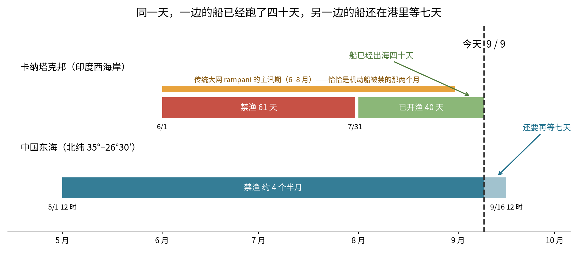
India's west coast has a statutory monsoon fishing ban. Karnataka's 2026 closure ran from June 1 through July 31, a total of 61 days - inclusive, that is exactly 61 - under the Karnataka Marine Fishing (Regulation) Act, 1986. It applies to mechanized vessels and motorized boats with engines above 10 horsepower. Traditional nonmotorized boats and vessels with engines of 10 horsepower or less are exempt. Violators face legal action and lose their tax-exempt diesel subsidy for one year.
Then came an unexpected reversal.
This coast has a traditional fishing method called rampani: an immense shore seine hauled in by an entire village. Indian Institute of Science records describe four or five types, the largest more than a kilometer long and worked by roughly 50 to 150 fishers. A smaller version, the kairampani, takes its name from the Tulu word kai, meaning "hand," because people pull it by hand rather than rope. A 20-foot boat with eight or nine people sets a net 135 meters long and 12.5 meters wide; another 50 or 60 people haul it from shore for about two and a half hours.
According to the Central Marine Fisheries Research Institute, the main season for kairampani is precisely the June-to-August monsoon, because mechanized boats are banned for two of those months.
So this coast's most spectacular traditional fishing method depends not on good weather, but on everyone else's rest. During the wettest months, with the mechanized trawlers idle, dozens of people stand in the surf and pull. When motorboats return in September, the great nets recede.
That balance has collapsed. In 1976-77, about 150 rampani still operated along the coast, supplying 80.4% of the traditional catch and 47.7% of the total marine catch. By 1986-87, after more than 3,000 mechanized boats had entered the fishery, rampani's share had fallen to 5.6% of the total marine catch. There were 114 small kairampani units in 1972-73; fewer than 60 remain. The researchers' phrase is "on the verge of extinction."
One Correction: The Monsoon Has Not Left
At this point we planned to write, "In September the monsoon retreats and the fishers return to sea." The research forced us to delete it. That sentence is wrong.
The India Meteorological Department's official criteria say that withdrawal of the southwest monsoon from the southern peninsula, and therefore from the country as a whole, can occur only after October 1. We also checked each IMD release available today, September 9. No withdrawal has been announced. The western end of the monsoon trough lies north of normal, its eastern end near normal, and the forecast calls for widespread rain in Konkan and Goa from September 9 to 15, with isolated heavy rain in coastal Karnataka from September 12 to 14.
The real sequence is this: the fishing ban began June 1; June through August was the traditional great-net season; the ban ended July 31; mechanized boats sailed on August 1; fishers offered coconuts to the sea god at the coconut festival on August 27; and today, September 9, the coastal fishing season has been in full operation for exactly 40 days, but the rain has not stopped.
The rain does not depart on the same day the boats return.
The People in the Name, and the Port Beneath the Beach
The name Gabit Keni contains two things.
Keni is an actual village, administered under Ankola. Gabit is the name of a fishing community found across the Konkan regions of Goa, Karnataka and Maharashtra. Its members speak Malvani, not Konkani as is often assumed, and in Goa they are one of two distinct fishing communities alongside the Kharvi. A University of Mumbai paper says their range runs mainly from Ratnagiri to Honnavar - and Honnavar is only 45 kilometers south of Ankola, in the same district. The paper offers two possible origins for the name: one derives it from Gabhit, people who enter reef crevices to fish; the other from the Maratha warship Gurab, through Gurabit to Gabit. Cited evidence places the word in use by 1580.
Bing's own English description says the beach is named for the local Gabit fishing community. We tried to verify that independently through government community lists and anthropological literature but found no second source. The claim therefore remains Bing's: that is what it says, and we could not corroborate it - though the Gabit range certainly reaches to within 45 kilometers of the beach.
There is one thing Bing does not mention that belongs in any record of this place today.
A port is planned for the middle of this beach. In November 2023, a JSW Infrastructure subsidiary signed an agreement with the Karnataka Maritime Board to build a greenfield, deep-water commercial port at Keni, costing 4,119 crore rupees. It would chiefly handle coal and steel cargo and involve about 200 hectares of foreshore reclamation. In February 2025, hundreds of fishers, most of them women, entered the sea in protest; 24 were arrested. A public hearing on August 22, 2025, received more than 4,000 objections.
(Those specific figures come from Land Conflict Watch's compilation of local reporting and are a single secondary source. The agreement itself is supported by official and mainstream reports.)
Today's photograph therefore has a less comfortable reading: it may show what this beach looks like now, rather than what it will look like later.
No Occasion Today, but One in Five Days
We checked honestly: September 9 marks no observance related to India, Karnataka, the ocean or fishing.
But five days from now, on Monday, September 14, 2026, is Ganesh Chaturthi. It is the biggest festival of the year along the whole Konkan coast, from Mumbai through Goa to Ankola. Families welcome Ganesha into their homes and worship him for about ten days. Then, on Friday, September 25, Anant Chaturdashi, they carry the images out and immerse them in water.
The water is this sea.
(We found both dates only on multiple Indian calendar sites, not in a government holiday notice. Two independent sources agreed on them.)
So the picture marks no anniversary. It is the eve of one: the boats have been working again for 40 days, the rain has not quite ended, and the god has not yet arrived.
China's Fishing Boats Must Wait Another Seven Days
Bring this story back to China and an interesting contrast appears.
China has a summer fishing moratorium. Ministry of Agriculture and Rural Affairs Notice No. 1 of 2021 divides it precisely by sea area: in the Bohai Sea and Yellow Sea north of 35 degrees north, from noon May 1 to noon September 1; in the Yellow Sea and East China Sea from 35 degrees north to 26 degrees 30 minutes north, from noon May 1 to noon September 16; and in the East China Sea and South China Sea from 26 degrees 30 minutes north to 12 degrees north, from noon May 1 to noon August 16. The 2026 enforcement campaign runs from May 1 through September 16.
That creates this scene today:
Ankola's fishing boats have been at sea for 40 days. In China's East China Sea, boats must wait another seven.
Across the connected Indian and Pacific oceans, the two countries give fish very different holidays: 61 days in one, four and a half months in the other.
One more point runs opposite to what many people expect. An expert explanation on the China Meteorological Administration's website gives this chain of causation: the onset of the Bay of Bengal summer monsoon creates conditions for convection in the South China Sea summer monsoon; then "the onset of the South China Sea summer monsoon changes atmospheric circulation over southern Asia and ultimately triggers the Indian summer monsoon."
We tend to imagine India's rains arriving first and then moving toward China. The official account runs the other way: the South China Sea moves first; India follows.
Sources: Bing Daily Wallpaper metadata and official description; the India Meteorological Department (monsoon onset and withdrawal criteria and releases dated September 7 and 9, 2026); the Central Ground Water Board, Uttara Kannada District Brochure; the Geological Survey of India, Geology and Mineral Resources of Karnataka and Goa; UNESCO World Heritage, "Western Ghats"; the Indian Institute of Science Centre for Ecological Sciences (coastal landslides and the national biodiversity strategy chapter); the Central Marine Fisheries Research Institute (kairampani research); the Karnataka Department of Fisheries fishing-ban notice; the University of Mumbai, Gabit: The Maritime Community of Southern Konkan; Land Conflict Watch and Mongabay India on the Keni port project; Ramsar Sites Information Service form for Site 2534; Ministry of Agriculture and Rural Affairs of the People's Republic of China Notice No. 1 of 2021 and the 2026 summer fishing moratorium enforcement plan; the China Meteorological Administration's expert explanation; the Institute of Geographic Sciences and Natural Resources Research, Chinese Academy of Sciences; the National Marine Data and Information Service; and photographer Amith Nag's own account.