
Anak Krakatau in Indonesia's Sunda Strait, photographed by Landsat 8 on September 5, 2026
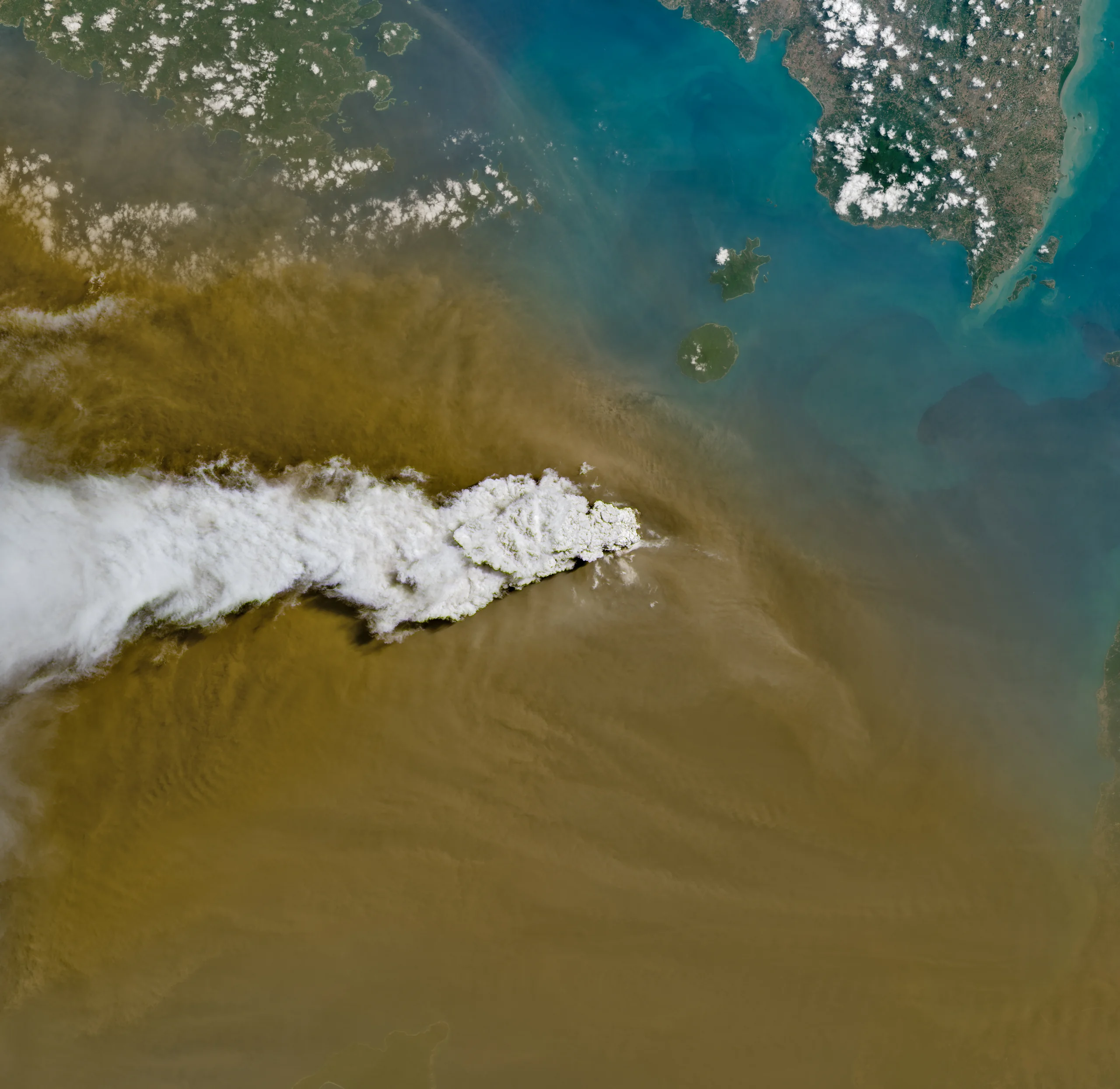
Image: NASA Image of the Day | Image credit: NASA/Michala Garrison | Image page
This photograph was taken from more than 400 kilometers above Earth. The white is volcanic gas; the brown is ash. The black speck beneath them is an island less than 200 meters tall.
Its name is Anak Krakatau, Indonesian for the Child of Krakatau.
The name contains an entire history. The volcano really did have a parent, and in 1883 that parent blew itself apart.
First, What Happened This September
The timing is unexpectedly precise.
A bulletin from Indonesia's Center for Volcanology and Geological Hazard Mitigation records a continuous eruption that began at 11:07 p.m. Western Indonesian Time on September 4, 2026 and ended at 12:04 a.m. on September 6, lasting 25 hours. Counted by the minute, that is 24 hours and 57 minutes, so the official "25 hours" is a reasonable rounding.
During those 25 hours, lava fountains rose 100 to 400 meters above the crater. Indonesia's meteorological agency reported that by September 6, ash had reached altitudes of 6,000 meters east of the volcano and 15,000 meters west of it. Eight airports on Java and Sumatra closed temporarily, affecting nearly 3,000 flights, and ash fell across Jakarta and parts of West Java.
NASA Earth Observatory published an article by Lindsey Doermann on September 9, using the photograph above. One detail deserves particular attention. Indonesia's humanitarian coordination platform specifically clarified that volcanic ash is not the same as the haze from peatland fires common in Indonesia. Their particles differ, they disperse differently, and they require different protective measures. Local agencies made the distinction explicit because the public can easily confuse the two.
The continuous eruption ended after September 6, and the volcano returned to its more usual Strombolian pattern, ejecting material intermittently. All airports reopened by September 8. The alert level, however, did not fall. Since July 2, 2026, Anak Krakatau has remained at Level III, "Standby," on a four-level scale, with a three-kilometer exclusion zone.
The explanation Indonesian authorities gave on September 15 was direct. The volcano has an open conduit, allowing hot, low-viscosity magma to rise almost unobstructed, so it grows quickly. They also offered a safety judgment: the cone is now about 150 meters high, with gentle slopes, and even a small collapse would not be sufficient to generate a tsunami.
Why did that point need to be made? Because eight years ago, the same mountain demonstrated the opposite.
1883: A Sound Carried 4,800 Kilometers
The parent's story must come first if the child is to make sense.
On the afternoon of August 26, 1883, Krakatau entered the climactic phase of its eruption, sending a black ash column 27 kilometers into the sky. On Monday, August 27, a series of 11 tremendous explosions followed, the largest at 10:02 a.m.
The sound reached Rodrigues Island, 4,800 kilometers away, near Mauritius. People there heard it, but thought a ship nearby was firing its guns.
That distance is 12% of Earth's equatorial circumference. At the speed of sound in ordinary air, the noise would have taken nearly four hours to arrive. In the other direction, it was also heard at Perth, Australia, more than 3,100 kilometers away.
One widely repeated claim needs correcting. You may have heard that the explosion's pressure wave circled Earth seven times. It did not. The Royal Society's famous 1888 report says that barometers recorded seven passages of the wave over five days: four traveling outward from the volcano toward its antipode, and three returning. Seven passages amount to three and a half circuits.
Seven and three and a half have been confused for more than a century. More interesting still is the report itself.
In the year of the eruption, the Royal Society's council formed a special committee with a straightforward mission: gather records of the eruption and its accompanying phenomena, preserve them properly and make them useful. It solicited observations from around the world - falling pumice and ash, anomalous air pressure and sea levels, the smell of sulfur, the distance at which the explosions were heard, and strange light and color in the sky.
This was global crowdsourced science in 1883. After one eruption, the world's barometers, tide gauges and sunset watchers all submitted their work.
The human cost was appalling. The Dutch East Indies authorities recorded 21,565 deaths in Banten, 12,466 in Lampung, 2,350 in Batavia, 34 in Bengkulu and two in West Java, a total of 36,417. It is not a rounded estimate but the sum of provincial counts. Most victims died in the tsunamis; about one in ten were killed by pyroclastic flows that crossed the strait toward Sumatra.
That Winter, Sunsets Went Wrong Around the World
In the year after the eruption, average Northern Hemisphere summer temperatures fell by 0.4 degrees Celsius.
The changes in the sky were more immediate. Sunsets around the world remained abnormally red for months. How abnormal? Fire departments in New York City, Poughkeepsie and New Haven were called out because the horizon looked as though it were on fire. There were other strange sights: blue Moons, lavender Suns and the first recorded noctilucent clouds in human history.
That led to a dispute that continues today: did Krakatau paint the blood-red sky in Edvard Munch's The Scream?
The case for: In 2004, a team from Texas State University published an investigation in Sky & Telescope. They found Norwegian newspaper reports of blood-red skies in November and December 1883 and concluded that the painting showed twilight colored by volcanic aerosols.
The case against: A 2018 paper in the Bulletin of the American Meteorological Society proposed another explanation: nacreous clouds, or polar stratospheric clouds, a familiar winter phenomenon in southern Norway. Its key evidence is the timing. Krakatau's optical effects were visible in southern Norway from late November 1883 through February 1884, while Munch's diary dates the red sky to January 22, 1892, nine years later.
The finest detail is that Robock, one of the coauthors of the paper arguing against the volcanic explanation, was one of the first people to propose that explanation in the first place. He publicly overturned his own idea, and not only once.
One side sees the afterglow of a nine-year-old eruption; the other sees a cloud native to a Norwegian winter night. Both brought evidence, and neither has won. It may be one of the best science lessons to give a child: science is not a list of answers, but an argument still in progress.
The Essential Point: It Grew Beside Its Ancestor's Wound
Now the island's ancestry can be told properly, beginning with a common misconception.
Before 1883, Krakatau Island consisted of three joined volcanic cones: Rakata, Danan and Perbuwatan. Danan and Perbuwatan were destroyed in 1883; only the southern half of Rakata remained, as a cliff more than 800 meters high.
The two other islands on the map, Sertung and Panjang, were not created in 1883. They are fragments of the rim left by a much older caldera collapse, possibly in 416 or 535 CE, making them more than a thousand years older than the 1883 eruption.
After 1883, then, a ring of island fragments remained at the surface. The middle was empty: a steep submarine pit blasted into the seafloor.
The child emerged inside that pit.
Submarine eruptions began in late 1927, and a new island rose above the water within days. Waves flattened it. A second island rose and was flattened. So was a third. Only in August 1930 did the fourth island finally endure, because the eruptive material had changed from soft pumice and ash to more erosion-resistant lava.
It continued growing, reaching more than 300 meters by 2018.
Then, at 13:55 UTC on December 22, 2018, its entire southwestern flank collapsed into the sea.
The mountain fell from more than 300 meters to just over 100. In a single night, it lost about two-thirds of its height. The exact figures vary by source: a peer-reviewed paper gives a fall from 320 to 120 meters, while Indonesian authorities give 338 to 110 meters.
The chilling part is that the reason had been written down six years earlier.
In 2012, Giachetti and colleagues noted that Anak Krakatau was "mainly constructed upon the steep northeastern wall of the 1883 caldera, while its active side faces southwest" - toward the 1883 pit - "making the whole structure quite unstable." They even modeled a southwestward flank collapse, calculating an initial wave height of 43 meters and an arrival at Java's west coast 35 to 45 minutes later.
It grew beside the wound of its ancestor, and the shape of that wound determined which way it would fall.
In 2019, another paper described the cycle as a mechanism: the rate of regrowth is the main factor controlling the time between collapses. The faster it grows, the sooner it falls again.
The island does not simply "grow" through eruptions. It lives through a cycle of growth, collapse and regrowth. Its present height, about 150 to 160 meters, is not a number that rises steadily. It fluctuates as later eruptions remove the summit and rebuild the flanks.
There Was No Warning Because the System Awaited an Earthquake That Never Came
The official toll from December 22, 2018 was 437 dead, 31,942 injured and 10 missing. The maximum run-up, 14.9 meters, occurred at Sumur in Banten Province.
That evening, a company was holding an end-of-year performance on the beach at Tanjung Lesung in Banten. When the wave arrived, there had been no warning.
Why not? Indonesia's tsunami warning system then worked by detecting an earthquake first and calculating the waves from it. But the wave that night had been pushed outward by a landslide, not a tectonic earthquake. No earthquake meant no trigger, and no trigger meant no warning.
There is another fact worth remembering. Later research found that the collapse was not entirely without signs. It had been preceded by a thermal anomaly, growth in the island's area, and the slow seaward movement of the southwest flank. The paper's conclusion is understated but heavy: "This hazard was not systematically monitored."
The signal existed. No one was watching that signal.
Indonesia's response was not to make its seismometers more sensitive. Its meteorological agency began developing InaTNT, a non-tectonic tsunami system using tide gauges, buoys, high-frequency radar and automatic water-level stations to measure the sea itself directly. The Sunda Strait is its pilot area.
Before 2018, the system asked, "Was there an earthquake?" After 2018, it began asking, "Did the sea move?"
Sometimes the thing that saves lives is not a better answer, but a different question.
One comparison restores the scale. The 2018 collapse displaced about 0.1 cubic kilometers, only one two-hundredth of the roughly 20 cubic kilometers erupted in 1883. An event one two-hundredth the size still killed 437 people. The researchers' conclusion is the same: even a seemingly modest flank collapse during a small eruption can have catastrophic consequences.
A Spider, and an Experiment Still in Progress
Now for something happier.
The 1883 eruption destroyed all plant and animal life on Rakata. The word researchers use is "sterilized."
In May 1884, the first researchers landed. The only living thing they found on the entire island was a spider in a crevice on Rakata's southern side.
Not a tree, not grass, not moss. One spider, carried there by the wind.
Life then returned species by species. The number of land-bird species rose as follows:
1908: 13. From 1919 to 1924: 28. From 1951 to 1952: 33. From 1984 to 1986: 36.
Twenty-five years after zero, there were 13 species; after a century, 36. The curve rises quickly, then gradually flattens, a pattern a child can recognize at a glance.
The significance extends much further. MacArthur and Wilson used the rates at which birds and vascular plants recolonized the Krakatau islands to test their equilibrium model of island biogeography. The islands were not merely related to the theory; they were the laboratory on which it rested.
The final word belongs to patience. After 143 years, researchers still say that no component of the flora or vegetation here is approaching a stable state.
The experiment is not finished.
The Satellite Has 11 Eyes
Landsat 8 took this photograph. Launched on February 11, 2013, it orbits at an altitude of 705 kilometers, images a swath 185 kilometers wide and returns over the same place every 16 days.
Its Operational Land Imager has nine spectral bands, while its Thermal Infrared Sensor has two more. Human eyes have three kinds of color receptor - red, green and blue. Landsat 8 has 11 bands, two devoted to temperature. It can see not only that the volcano is smoking, but how hot it is.
One further point: this is a true-color image. The white and brown are the white and brown an eye would really see from that altitude. No one added the colors.
Why monitor a volcano by satellite? Because the island lies in the middle of the sea and no one is allowed within three kilometers; because people cannot approach it during an eruption; because shortwave infrared can penetrate some smoke and ash; and because a pass every 16 days, year after year, creates a comparable time series. There is no more reliable way to measure how much the mountain has grown in a year.
There is another, usually invisible chain. Australia's Darwin Volcanic Ash Advisory Centre uses satellite data like these to issue ash advisories, which airlines use when deciding whether to reroute flights. That chain was operating behind the closure of eight airports and the disruption of nearly 3,000 flights in early September.
In China, a Burned Tree Named the Year That Killed It
China has a volcano that did something larger than Krakatau 1,080 years ago.
The Millennium Eruption of Changbaishan's Tianchi volcano was one of the largest eruptions of the Common Era. But scholars argued for years about when it happened, with estimates scattered across the 10th century.
In 2017, an international team pinned it down to a year, using a method as elegant as a detective story.
They first found a larch swept up and killed by a pyroclastic flow, then immediately buried. In its rings they located the radiocarbon spike from the global cosmic-ray event of 775 CE, a year-precise marker shared by trees around the world. From that marker they counted outward, ring by ring, to the year in which the tree burned. Finally, they aligned the result with the chemical signal in Greenland ice cores.
The answer: late autumn or winter of 946 CE.
A burned tree used its own rings to report the year that killed it.
Across the sea, a chronicle kept at Kōfuku-ji in Nara contains one line for the night of the seventh day of the tenth month in the ninth year of Tengyō: "White ash fell like snow that night." In the Gregorian calendar, it was November 3, 946. One common error is worth correcting: the line comes from the Kōfuku-ji Nendaiki, not the Nihon Kiryaku. A volcano on the China-Korea border scattered ash over Japan. A thousand years later, scientists recovered it from lake mud and matched it to Greenland ice and the rings of a larch.
The eruption's scale remains disputed. It was traditionally classified as VEI 7, but a 2021 paper recalculated the volume and argued that it was VEI 6, not 7, and "smaller in magnitude than previously thought." Another argument without an ending, paired neatly with the debate over The Scream.
Today, Changbaishan is an active volcano, but it is sleeping. The Changbaishan Volcano Observatory, under the Institute of Geology at the China Earthquake Administration, now operates 15 monitoring substations using 14 kinds of measurement. It is China's largest and most comprehensively equipped volcano monitoring station. An InSAR study published in 2023 offered a checkup: from 2015 to 2022, the crater and its surroundings were slowly subsiding overall. A shallow magma chamber about six kilometers deep was contracting by roughly 330,000 cubic meters a year. The volcano had inflated conspicuously from 2002 to 2005, after which its activity gradually weakened.
In Indonesia, people measure Anak Krakatau's height and earthquakes every day. In China, 15 substations watch a sleeping mountain. Two volcanoes, and the same work in two places.
Even a sleeping volcano needs someone listening to its pulse through the night.
Sources: NASA Image of the Day for September 16, 2026; NASA Earth Observatory, Anak Krakatau Rumbles Again (September 9, 2026), by Lindsey Doermann; July 2 and September 7, 2026 bulletins from Indonesia's Geological Agency and Center for Volcanology and Geological Hazard Mitigation; the Smithsonian Institution Global Volcanism Program file for volcano 262000 and its Weekly Volcanic Activity Report; G. J. Symons, ed., The Eruption of Krakatoa and Subsequent Phenomena (Royal Society Krakatoa Committee report, 1888); the Royal Society, Crowdsourcing Krakatoa; Olson, Doescher and Olson, When the Sky Ran Red, Sky & Telescope (2004); Prata, Robock and Hamblyn, The Sky in Edvard Munch's The Scream, BAMS 99:1377-1389 (2018); Giachetti et al., Geological Society, London, Special Publications 361:79-90 (2012); Walter et al., Nature Communications 10:4339 (2019); Williams et al., Geology 47:973-976 (2019); Syamsidik et al., NHESS 20:549-565 (2020); the Indonesian meteorological agency's description of InaTNT; Thornton et al., PNAS 85:515-518 (1988); research by Whittaker and colleagues on vegetation succession at Krakatau; the U.S. Geological Survey Landsat 8 mission page; NASA Worldview; Oppenheimer et al., Multi-proxy Dating the "Millennium Eruption" of Changbaishan to Late 946 CE, Quaternary Science Reviews 158:164-171 (2017); Yang et al., The Millennium Eruption of Changbaishan Tianchi Volcano Is VEI 6, Not 7, Bulletin of Volcanology 83 (2021); Xinhua, Watching Over Changbaishan Volcano; and Xiong Guohua et al., InSAR Deformation and Activity Analysis of Changbaishan Tianchi Volcano, 2015-2022, Seismology and Geology 45(6) (2023).