
From orbit, the geography of human settlement becomes a pattern of light.
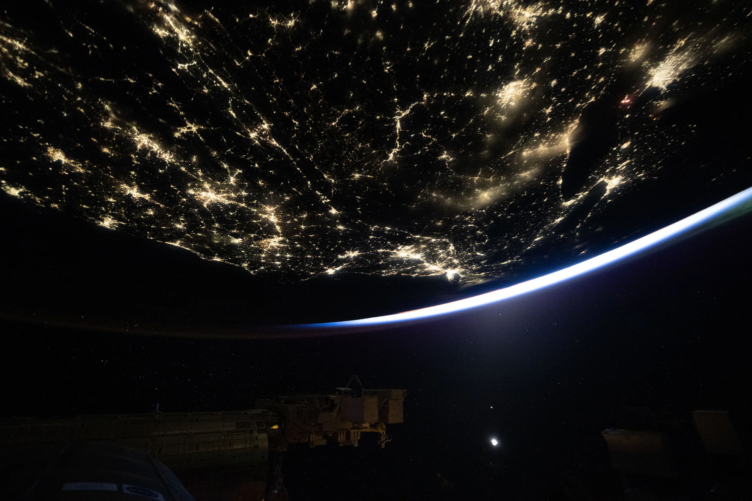
Image: NASA Image of the Day | Image credit: NASA/Jessica Meir | Original page
NASA published this image on September 28, but the photograph was taken on September 8, 2026, at approximately 3:40 a.m. local time. The International Space Station was orbiting 259 miles, about 417 kilometers, above Earth. The view looks toward New York City near the center.
Cities do not spread evenly across a landscape. Their lights gather along coasts, trace roads and cluster into bright knots. From this height, settlement patterns become visible before individual buildings do.
The station circles Earth in a little over 90 minutes, giving its occupants roughly 16 sunrises and sunsets each day. This is one of the views between them.
What the Photograph Can Tell Us
The hour invites an obvious question: how much of this lighting is needed?
The photograph alone cannot answer it. Cities still need some illumination overnight, and light reaching an orbital camera can come both directly from fixtures and indirectly from illuminated roads and buildings. Reflected light may already have served a useful purpose on the ground. Every bright point is not automatically wasted energy.
Unnecessary upward light, excessive brightness and poorly chosen operating hours are more specific problems. Shielding can direct more of a lamp's output toward the area that needs it, though some light will still reflect upward from the ground.
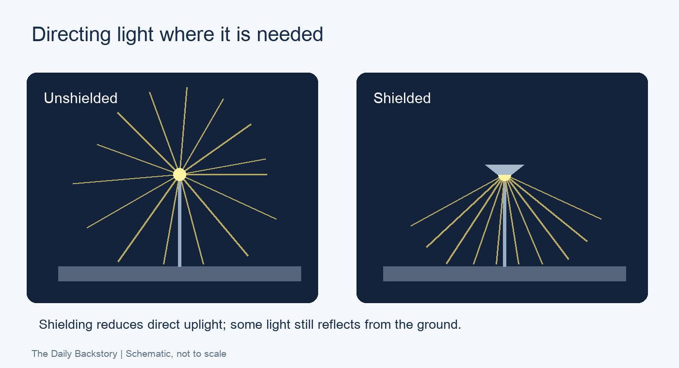
Diagram: The Daily Backstory; schematic, not to scale.
The image maps light. Evaluating that light requires additional information about where it comes from, where it goes and who needs it at that hour.
A Night Sky Measured by Human Eyes
A study published in Science in 2023 approached the issue from the ground. Researchers analyzed more than 50,000 Globe at Night observations collected between 2011 and 2022. Participants compared the stars they could see with reference charts, providing estimates of the faintest stars visible to the unaided eye.
The results implied an average increase in sky brightness of about 9.6% per year across the observations analyzed. Coverage was strongest in Europe and North America; this is not a claim that every place on Earth brightens at the same rate.
Satellite estimates of nighttime surface brightness had suggested a smaller increase, around 2% annually. The quantities and observing methods differ: an instrument looking down at Earth's surface does not measure exactly what a person sees looking up through the atmosphere.
Lead author Christopher Kyba illustrated the consequence with a childhood-scale comparison. At the inferred rate, a place where 250 stars were visible when a child was born could show only about 100 by the time that child turned 18.
The stars have not vanished. The brighter background makes the fainter ones harder to distinguish.
Studying Earth After Dark
Nighttime imagery also provides useful information about human activity. China's Luojia-1 01 satellite, developed under Wuhan University's leadership with Chang Guang Satellite Technology, launched on June 2, 2018. Its experiments included nighttime remote sensing and low-orbit navigation enhancement; its night-light imagery has a spatial resolution of about 130 meters.
Such observations can support studies of settlement, economic activity, major disruptions and fishing operations that use bright lights. They offer an independent source of evidence, although brightness is not a simple one-to-one measure of economic output.
Night-light satellites can also support light-pollution research. The distinction remains essential: the illuminated ground seen from space and the glowing sky seen from the ground are related, but they are not the same measurement.
Sources
NASA Image of the Day: Original page; NOIRLab: Globe at Night findings; Kyba and colleagues, Science (2023); Journal of Remote Sensing: Luojia-1 01 design and processing; Wuhan University: satellite launch report. Further context: NASA Expedition 75 and Phys.org's account of the sky-brightness study.