
A line repeated for more than 160 years, and two bays governed by entirely different physics.
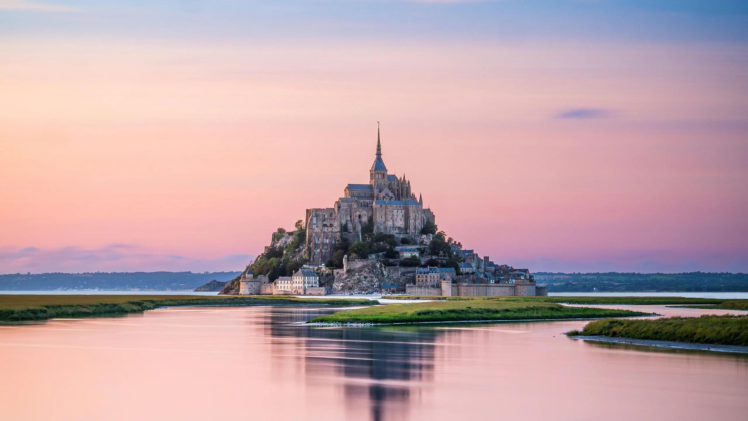
Image: Bing Daily Wallpaper | Mont-Saint-Michel at high tide, Manche, Normandy, France (© Clement LEONARD/Getty Images) | View on the Bing homepage
Open Bing today and a mountain appears to float on the water.
Its stone spires narrow tier by tier into one fine point. Beneath the spire stands an abbey, beneath the abbey a wall, and beneath the wall - where there should be a beach firm enough to cross on foot - there is now only water. The setting sun presses down from the west, burning the surface gold while the mountain's reflection trembles below. Bing calls the photograph A Legend Shaped by the Tides.
This is Mont-Saint-Michel in Normandy's Manche department. It is famous for many reasons. A bishop built the first sanctuary here in 708. Over the next eight centuries, it grew into an abbey suspended in the air, then spent another four centuries as a prison. But what draws people from around the world is the thing in this photograph: the water.
A Line Repeated for More Than 160 Years
The most familiar claim about the tide here is that it comes in as fast as a galloping horse.
The line is irresistible. It has imagery, speed and danger, which is why nearly every account of Mont-Saint-Michel repeats it. But it is false.
Begin with the speed. French scholar Fernand Verger gives the measured order of magnitude in Tides and the Human Geography of Coasts: the tide advances at about one meter per second, or 3.6 kilometers per hour, rising to roughly six kilometers per hour at most. Across the tidal flats it is slower still, only around 0.6 meters per second. French popular-science media give a somewhat higher figure of eight to ten kilometers per hour. The sources disagree, but their conclusion is the same: the speed ranges from a brisk walk to a jog. A horse averages around 21 kilometers per hour at a gallop and can reach 60 on a racetrack.
Then there is the attribution. The line is usually credited to Victor Hugo, but it was more likely written by another French author, Théophile Gautier. French-language sources say he coined the metaphor after witnessing an exceptional tide in 1859, describing "a charge of white cavalry."
Does that mean the bay is safe?
Not at all. But speed is not the danger. Mont-Saint-Michel's official tourism site says plainly that venturing into the bay alone is extremely dangerous, including in the immediate vicinity of the Mount, and that a licensed guide is required. Three things pose the real risk. The water can surround you: at low tide the sea retreats as far as six kilometers offshore, then returns from three directions at once. You are not overtaken so much as left with no dry ground around you. There are also strong currents and quicksand.
One exaggerated metaphor has obscured three real hazards. That is the first point of this story: a widely repeated claim can be both vivid and wrong.
Why the Tide Is So Large Here
The astonishing feature is not its speed but its range.
Two terms that are easily confused must first be separated. Tidal range is the difference between high- and low-water levels at the same place. Water level is an absolute height measured against a reference datum. Mont-Saint-Michel's official tide calendar lists 12.79 meters. That is a water level, not a tidal range. Quoting it as the range is the most common error in this subject.
As for the range itself, official sources disagree, and that disagreement deserves to be made explicit. The French Geological Survey says in its 1:50,000 geological map notes that the range is 14 meters, exceptionally reaching 15, and ranks Mont-Saint-Michel Bay fifth in the world. The Mont-Saint-Michel tourism office says "up to 15 meters." A joint case study from the Ramsar Convention on Wetlands and UNESCO calls it an "exceptional tidal range of over 13 meters" and "the second highest tidal range in Europe," reaching 16 meters at the largest tides and averaging 10 to 11 meters. Within the same convention system, one source says fifth in the world and another second in Europe. Britain disputes the latter claim: the Severn Estuary Partnership, an official UK body, calls its estuary's range the highest in Europe, at more than 12 meters on spring tides.
The more honest description, then, is that this is one of the world's largest tidal-range bays; its exact rank depends on the measuring station, the definition, and whether average or extreme values are being compared. The official figures differ not because anyone is lying, but because the phrase "tidal range" requires a precise account of what is being measured.
Why does it happen here?
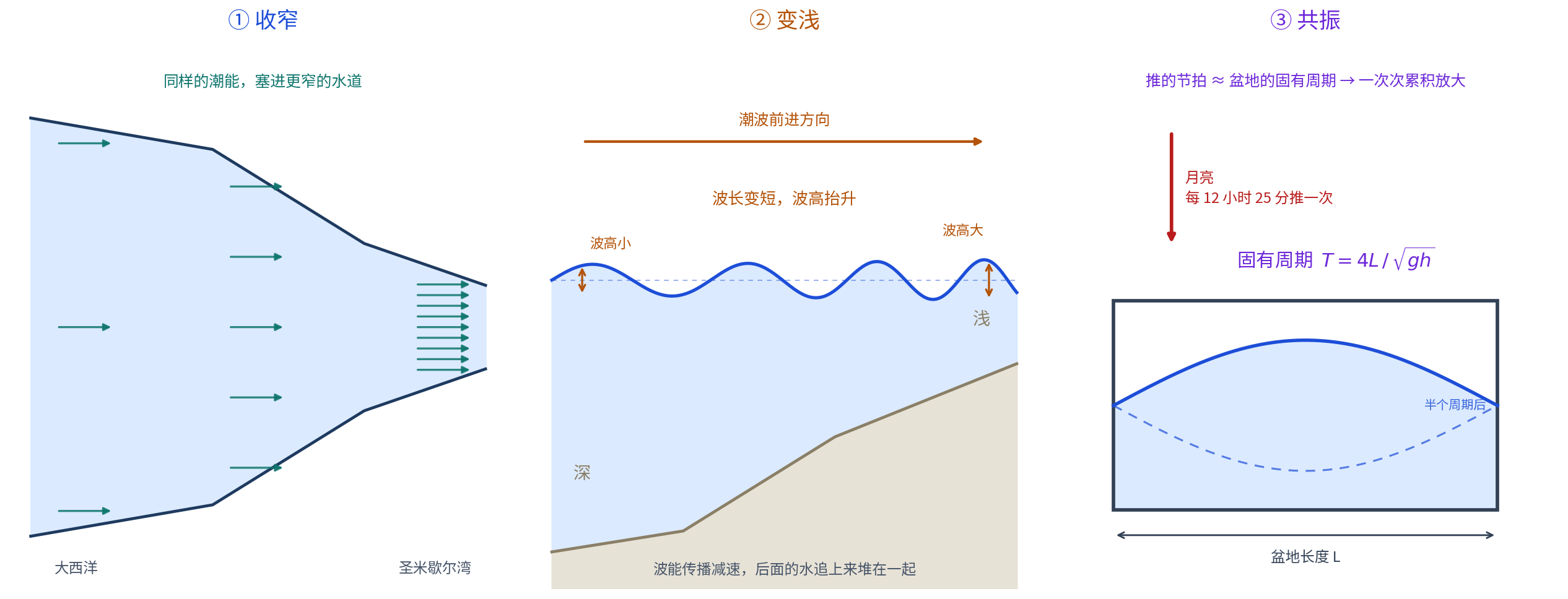
It is tempting to imagine that the Moon pulls harder here. It does not; the Moon's tide-generating force is nearly the same everywhere on Earth. The real reason is that water is squeezed into a funnel that grows narrower and shallower while moving in step with its own natural rhythm.
The coastal engineering reference Coastal Wiki separates tidal amplification into three mechanisms, each more interesting than the last:
Funneling: "tidal energy flux is concentrated in regions of decreasing width." Force the same energy into a channel half as wide and the water level must rise higher.
Shoaling: wave energy propagates more slowly in shallow water. As the tide wave slows, the water behind it catches up and energy accumulates.
Resonance: the most elegant mechanism. Every basin has a natural oscillation period determined by its length and depth. When the rhythm pushing it approaches that natural period, the motion accumulates and grows. The hand supplying the rhythm is the Moon; the principal semidiurnal tide has a period of about 12 hours 25 minutes.
Coastal Wiki's worldwide list puts it this way: maximum spring tidal ranges can exceed 14 meters in funnel-shaped bays such as Canada's Bay of Fundy, Britain's Bristol Channel and France's Mont-Saint-Michel Bay. All three are funnels.
The official French explanation emphasizes the funnel and shallow water. Granville Terre et Mer's tourism site says that a great mass of Atlantic water surges into the English Channel over a few hours. Because the Channel is much shallower and holds less water, its level rises much higher; the bay itself acts like a funnel receiving many currents. Curiously, the French official page never uses the word "resonance" and gives no figures. Resonance is the scholarly explanation, while the funnel is the official one. The two do not conflict, but resonance should not be placed in the French authority's mouth.
All of France Uses One Port to Rate Its Tides
France has a particularly revealing system for describing the size of a tide.
It uses the tidal coefficient, or coefficient de marée. The French Naval Hydrographic and Oceanographic Service defines it by the formula C = (H - N₀) / U × 100, on a scale from 20 to 120. A coefficient of 100 means the average tidal range of spring tides following an equinoctial new or full moon.
Here is the key: the coefficient for all of metropolitan France is calculated from one reference port, Brest, then applied to the entire mainland coast with local time differences taken into account.
The coefficient is not a local tidal range. It is a nationwide scale for the strength of the Moon's pull that day. That resolves an apparently strange combination: Mont-Saint-Michel can have a coefficient of 102 while its water level is only 12.79 meters. The coefficient describes how hard the Moon is pulling; the meter figure describes how high the water rises at this location. One is cause, the other effect.
When Does a Mountain Count as an Island?
"How many days a year does Mont-Saint-Michel become an island?" is a common question with an unusual answer: the question is framed incorrectly.
France's official 2026 tide calendar for Mont-Saint-Michel marks a series of thresholds, each corresponding to a different meaning of "surrounded by water."
At 12.20 meters, the route between the rocks can still be used. At 12.70 meters, the entire platform is placed on flooding alert. At 12.80 meters, the square becomes inaccessible. At 13.00 meters, the calendar prints "ISLAND" in capital letters: the high-tide protocol takes effect and access is prohibited.
The highest water level anywhere in 2026 is 12.79 meters. By the official 13-meter threshold, the Mount does not qualify on a single day this year. It misses even the inaccessible-square threshold by one centimeter.
Yet the tourism office's English page says that the Mount becomes an island only 4 hours 30 minutes after the tide begins to rise, and that this occurs about once every two weeks.
Both official statements are correct because "becoming an island" has two definitions. Water can flow around the rock and cut the Mount off from the landward side, which happens commonly, around every two weeks during spring tides. Or the official island protocol can be triggered, with the causeway and parking area submerged and vehicles barred, which is rare and requires a 13-meter water level.
The lesson is not to memorize "X days per year." It is that the answer can differ by dozens of times when the same event is measured with different rulers.
People Corrected Their Own Mistake
In 1879, France built a causeway to make Mont-Saint-Michel easier to reach.
The price was that it began to stop being an island. The causeway blocked tidal currents, sediment accumulated around the base, and the sea found it increasingly difficult to pass around the other side. The "legend shaped by the tides" was slowly being buried in the mainland.
Then came an engineering project, documented in full on its official French website.
The Couesnon River dam has eight curved gates, each nine meters wide and 7.4 meters high, with five piers and two fish passages. Construction began in 2006. The gates first moved experimentally in January 2008, the first sediment-flushing release took place in May 2009, and construction ended in June 2009.
The gates, in the official description, work in both directions, whether water flows upstream or downstream, according to tidal conditions. In plainer terms, they open during the rising tide to store seawater upstream in the Couesnon, then release it all at once on the ebb, flushing sediment back to sea. Official documents say the sediment is driven seaward from the Mount, one tide after another.
The principle is as simple as a toilet flush. One release cannot clear everything, but two a day over years make a difference.
The companion structure is a 760-meter stilt bridge designed by architect Dietmar Feichtinger and opened to pedestrians in the summer of 2014. Its critical feature, in the official documentation, is a light structure that is "transparent" to the tide and does not block the water. Demolition of the old 1879 causeway began that autumn.
The project's finances are public. Its website gives a total budget of EUR 200 million, including EUR 184 million in public investment, with EUR 21.15 million from the European Union and EUR 24 million from a private company. As an aside, 184 million plus 24 million does not equal 200 million. The official figures themselves are inconsistent, so they are reproduced here without adding them together. The project ran from 2005 to 2015 and serves, according to official statistics, 2.5 million visitors a year.
UNESCO later offered this verdict: following the major restoration project completed in 2015, Mont-Saint-Michel's maritime character had been restored.
More than 130 years, one causeway and EUR 200 million. People damaged it, then repaired what they had done.
From the Moon to the Dinner Table
The bay contains another causal chain, perhaps the best in this story, because it runs from astronomy all the way to dinner.
The official certification register of France's National Institute of Origin and Quality includes a product called Prés-salés du Mont-Saint-Michel, with AOP protected designation of origin status. Registered in the European Union on November 12, 2013, it covers 98 cantons and roughly 370 communes across Manche, Ille-et-Vilaine, Calvados, Cotentin-Marshes and Mayenne. The product is lamb.
Its essential rule is simple: the lamb must graze on salt marsh for at least half its rearing period.
Why can that determine flavor? The certification document itself names three plants: alkali grass, sea arrowgrass and sea purslane, all salt-tolerant. The official description calls the meat juicy and deeply rose-colored, with marbling and an intense, persistent aroma.
Follow the chain from end to end: the Moon's rhythm -> the funnel and resonance of channel and bay -> seawater carried onto the flats twice daily -> salty ground where only a few plants survive -> sheep eating those plants -> naturally savory meat -> an EU-protected product in 2013.
From a satellite 380,000 kilometers away to a plate of lamb. Every link in the chain can be checked.
The China Connection: On the Qiantang River, the Saying Is True
Now return to "as fast as a galloping horse."
At Mont-Saint-Michel, the phrase is false. On the Qiantang River, it is true, and even an understatement.
A 2023 Xinhua report quotes engineer Ye Xiaojie on how the Qiantang River's cross tide forms. The lower river is wide and shallow, with many sandbars. When the tide front reaches the central bar, it splits into eastern and southern tides. The two fronts pass around the bar, collide and embrace, forming a spectacular, ever-changing cross tide. The same report supplies two figures: the Qiantang River's current can reach 10 meters per second, and the surge can exert seven metric tons of pressure per square meter.
Ten meters per second is 36 kilometers per hour. A galloping horse averages about 21.
The same proverb is false on one continent and true on another. A qualification is necessary: Xinhua's original uses the term "current speed" without saying whether it means the propagation speed of the tide front or the water's flow velocity, and it names no measuring station. It is therefore quoted here only as a maximum value.
More interestingly, the mechanisms differ.
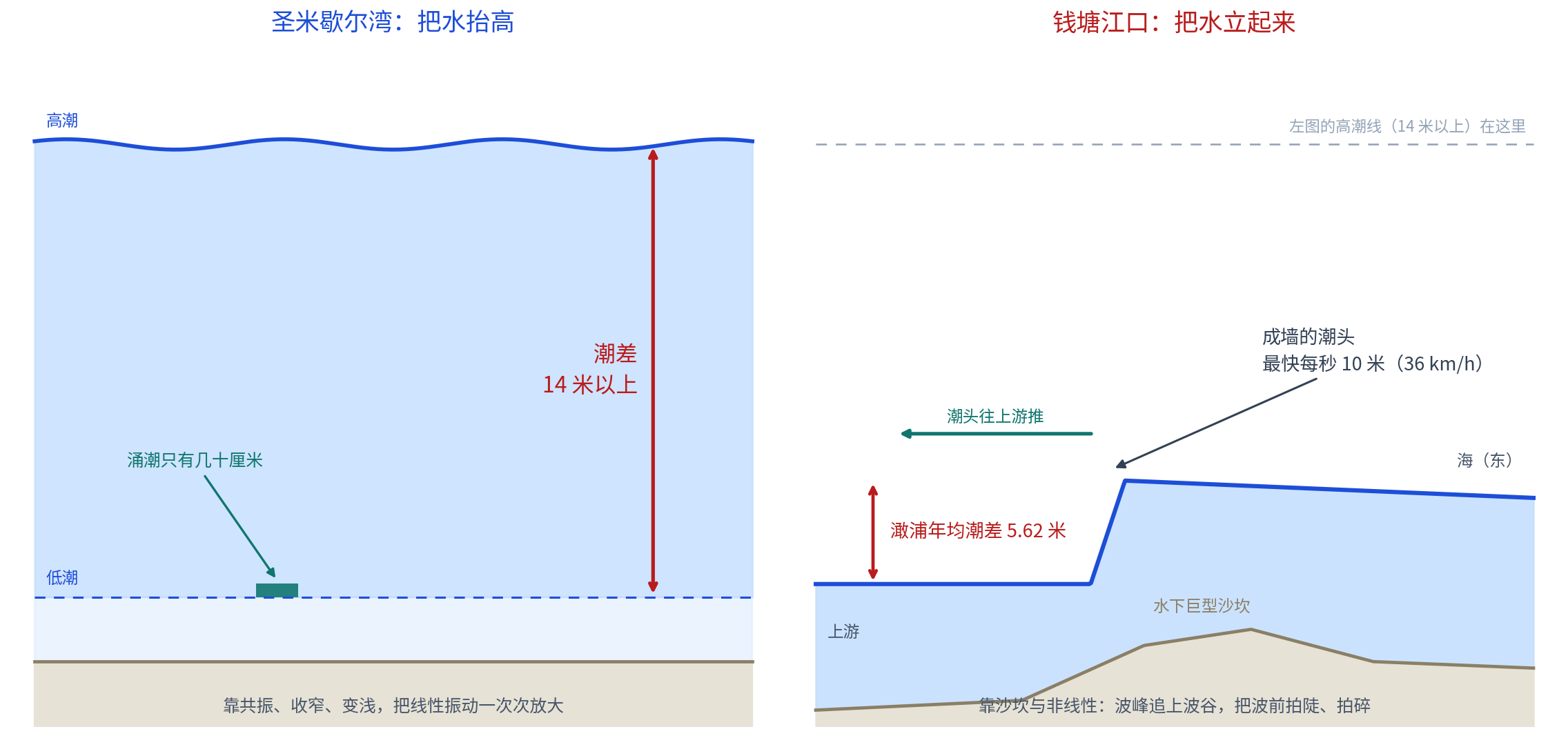
A peer-reviewed 2025 paper in Sustainability, "Hydrodynamics of the Qiantang River Tidal Bore and Its Response to Seawalls, Topography, and River Discharge," supplies the crucial parameters. Hangzhou Bay is 85 kilometers long. The annual mean tidal range at Ganpu is 5.62 meters, with a maximum of nine meters. The bore travels more than 120 kilometers upstream. The paper says the funnel-shaped shoreline concentrates tidal energy, while a giant underwater sandbank upstream of Zhapu promotes tidal-wave deformation and probably helps the bore form. The dominant physics are nonlinear advection and bed friction. It also reports a counterintuitive result: extremely high river discharge suppresses the bore.
The distinction between the two places is this:
Mont-Saint-Michel Bay lifts water exceptionally high. Resonance, funneling and shoaling repeatedly amplify a linear oscillation. Its tidal range exceeds 14 meters, but the tidal bore is only tens of centimeters high.
The Qiantang River stands water up into a wall. Ganpu's mean range is only 5.62 meters, far less than France's. But an underwater sandbank trips the front while the water behind catches up. The crest overtakes the trough as nonlinearity steepens and breaks the wave, creating the straight-line bore, the cross tide and speeds of ten meters per second.
One wins in height; the other in steepness.
The next fact emerged while the dates were being checked. It is this story's finest coincidence, or rather, not a coincidence at all.
In China, the traditional day for watching the tide is the eighteenth day of the eighth lunar month. In 2026, the Mid-Autumn Festival falls on Friday, September 25. Three days later, the eighteenth day of the eighth lunar month is Monday, September 28. Multiple almanacs agree on the Mid-Autumn date.
September 28 is also marked as a spring-tide day on the official French calendar cited above: coefficient 99, with high tides at 08:54 and 21:12.
China uses the lunar calendar to fix its tide-watching day. France uses a coefficient calculated from a single reference port at Brest to identify a grande marée. Two calendar systems and two engineering traditions, invented independently, point to the same astronomical fact: a new or full moon, compounded by the proximity of the equinox.
On the same day, people at opposite ends of Earth look up at the same Moon, then go to watch their own great tide.
One point must be explicit: at the time of publication, the official 2026 Qiantang River tide schedule for Haining had not been released. In previous years, including the 2023 Yanguan schedule published through the Haining municipal government portal, the official timetable usually appeared in mid-September. Schedules already circulating online came from commercial aggregation sites, not official data. The authoritative timetable would be the one eventually published at haining.gov.cn.
Sources: the French national public institution for Mont-Saint-Michel's official 2026 tide calendar and spring-tide notice at montsaintmichel.gouv.fr; the Mont-Saint-Michel tourism office; technical tide-prediction notes from the French Naval Hydrographic and Oceanographic Service's REFMAR network; the French Geological Survey's 1:50,000 geological map notes; the official Mont-Saint-Michel restoration project website and the Prefecture of Normandy; France's official EU funds portal; UNESCO World Heritage Site No. 80; Ramsar Site Information Sheet No. 709 and a joint Ramsar-UNESCO case study; AOP certification information from France's National Institute of Origin and Quality; Granville Terre et Mer; the UK's Severn Estuary Partnership; Coastal Wiki, "Ocean and shelf tides" and "Harbor resonance"; Xinhua; Chen et al., Sustainability 17(16):7363 (2025); China's National Marine Data and Information Service; and the Haining municipal government portal.